Zea (Grèce) : The Art of Harbour Archaeology
The Art of Harbour Archaeology
ZEA
Source - http://www.zeaharbourproject.dk/2011/12/the-art-of-harbour-archaeology/
Modern harbours pose a complicated challenge to the underwater archaeologist. Not only is there a lot of marine traffic and anchored ships, but many harbours are also very polluted. In the case of the Piraean harbours, Zea and Mounichia, the pollutants range from oil spills over city sewage to toxic elements from boat paints and heavy metals, to name a few. The seabed in Zea and Mounichia is covered with mud and garbage, some of it hazardous when handled in low visibility. The underwater archaeologist must know how to work within all these parameters to document the very important traces of our past hidden in the murky waters of the Piraeus.
Our three main objectives in 2011 were: 1) a geophysical survey of the Piraean submerged coastal area (see newspoint of October 27, 2011); 2) the investigation of the sunken harbour fortifications; 3) the excavation of the Group 1 shipsheds (M-G1) at Mounichia Harbour (modern Mikrolimano). In addition, we targeted a number of secondary objectives at both Zea and Mounichia.
Outside the modern harbour of Mikrolimano our restless digital survey team shot thousands of ‘points’ on hundreds of architectural features in and around the area of Tower M-T3, which guarded part of the southern fortified mole (Fig. 1). The remains are submerged in a few centimeters of water, down to a depth of more than 3 m, thus necessitating amphibious archaeological methods. The investigations were conducted both ‘wading’ in drysuits and crash helmets (safety first is always our motto) and diving. A very well preserved section of the fortified mole was discovered to the north of Tower M-T3 underneath the concrete blocks of the modern breakwater. In Figure 2 Mads Møller Nielsen is documenting for the first time the total width of the southern fortified mole. In Tower M-T3 we recorded digitally the deepest submerged man made feature in the Piraeus. The feature in question was constructed on land in Antiquity and the depth measurement which is all important for understanding the sea-level change since Antiquity, will be announced at the Annual Meeting of the Danish Institute at Athens on April 20, 2012.
In 2010 the M-G1 shipsheds were discovered in the northern side of the Mounichia Harbour, and this year we opened trenches in two shipsheds to obtain more information about the architecture and relative chronology of these structures. Many ceramic and organic finds were uncovered in closed contexts, which are very rare in the surf zone of the Piraeus. Once the finds are properly desalinated and conserved, they will offer us the unique opportunity to study the building phases of the M-G1 shipsheds and their chronology.
In most of the secondary target areas at Mounichia and Zea we did not have access to electricity necessary to use our standard electric water pumps to power the water dredges used for excavating under water. To cope with this logistical obstacle we constructed a floating platform carrying a diesel water pump, thus creating a mobile unit which could be launched in any part of the harbour basins and beyond. In the northwestern side of Mounichia we used the platform set-up to surface clean four column drums reused in the ramp of a shipshed (Fig. 3).
The 2011 season was very productive as we found most of the information that we were searching for. Now it’s time to clean, service and store our extensive machine park, excavation and diving equipment.

Fig. 1 Planning the digital survey of Tower M-T3
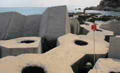
Fig. 2 Well preserved parts of the southern fortified mole are reachable between the blocks of the modern breakwater
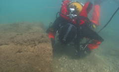
Fig. 3 Field director Ioannis Sapountzis examining two of these column drums