
Watson Brake, Sapelo Island, Poverty Point (USA) : Were mounds originally built to protect Native Americans from floods? Part.1
Were mounds originally built to protect Native Americans from floods?
Richard Thornton
Source - Were mounds originally built to protect Native Americans from floods? - National Architecture & Design | Examiner.com http://www.examiner.com/architecture-design-in-national/were-mounds-originally-built-to-protect-native-americans-from-floods#ixzz1NO4dh8fn
The oldest public architecture in the Western Hemisphere can be found in northeastern Louisiana. Is it a coincidence that prior to the construction of dams, levees and drainage canals, much of northeastern Louisiana was under water during the annual spring floods?
Drive west on Interstate 40 from Memphis, Tennessee. After crossing over the Mississippi River, you will enter Arkansas’s primary rice growing region. It stretches for over a 100 miles west of Memphis. As you drive along I-40 you will notice modern houses perched atop, what appears to be Indian mounds. Many farmers have also constructed their barns and tractor sheds atop earthen mounds. These small hills are not ancient Native American structures, but piles of dirt primarily erected during the 20th century.
Eastern Arkansas experiences the same floods by the Mississippi River as eastern Louisiana. During the spring, and sometimes after winter storms, these “American” mounds become man-made islands. The apparent inconvenience of placing one’s home 30 feet above one’s farm then becomes perfect clear. Arkansas’s rice farmers benefit from the annual flooding of the Mississippi that prepares the landscape for planting rice seedlings. A natural disaster for these farmers would be a year when the Mississippi does not flood!
The mounds of the Southeastern Indians were generally associated with major rivers. All of these rivers at least occasionally flooded. Could it be that mounds were originally built to provide a safe haven for villages during a flood, and later were constructed to keep the temples and elite’s houses above water during floods? Over time the association between mounds and the elite would have become an architectural tradition within itself, regardless of the potential threat of flooding.
Watson Brake, Louisiana – 3500 BC
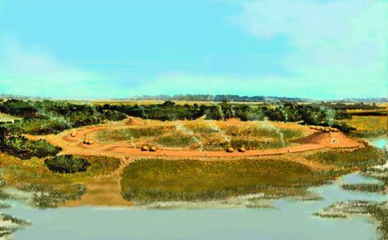
Watson Brake is the oldest known public architecture in the Western Hemisphere. It was discovered by Reca Bambourg Jones in 1981 in the flood plain of the Ouachita River near Monroe, Louisiana. The archaeological zone consists of 11 mounds arranged in an oval, varying in height today between 3 feet and 25 feet. (See the site plan in the attached slide show.) The oval has a major axis of about 900 feet and a minor axis of about 834 feet. The site is still owned by the Gentry family, and not open to the public.
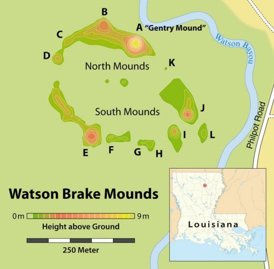
Some sections of the oval shaped earth berm probably have been eroded during the past 5,000 years by rains and floods. Credit: Wikipedia from Northeastern State University
Between around 3500 BC and 2800 BC earthworks were constructed at Watson Brake, Louisiana Credit: VR Image by Richard Thornton
Joe W. Saunders, a professional archaeologist associated with nearby Northeastern State University, studied Watson Brake. He use radiocarbon dating methods on some residual charcoal at the site to date its occupation from 4000 BC to around 2800 BC! Construction was begun on the mounds around 3500 BC. Because the dates he obtained seemed too old, he brought in forensic geologists from the University of Texas at Austin and the University of Washington to obtain probable occupation dates from analyzing sands and organic acids in the mounds. The alternative measurements matched his own.
Although 5,000 years of erosion and flooding may have washed away evidence, Saunders found few artifacts or evidence of long term habitation of Watson Brake. This situation influenced him to theorize that the site was not a village inhabited year round, but rather a location where hunter-gatherer bands would temporarily camp during certain seasons. He speculated that a cycle of heavy rainfalls during the period of the mounds’ use. The mounds would have elevated its builders above the flooding Ouachita River.
There is probably much more to Watson Brake than just being a safe haven during floods. There is no known functional reason for such a large cluster of mounds to be arranged in an oval. The site is contemporary with the oldest stone sun circles of Alberta. Dr. Gordon Freeman, a physicist at the University of Alberta, has determined that these rings were sophisticated observatories, which predated the construction of Stonehenge. (See link below on the Alberta stone circles.) A thorough analysis of the geometric relationships at Watson Brake will be required before any further interpretation is possible.
Other early mounds in the Southeast
The next flurry of mound-building in the Southeastern United States began about 400 years after Watson Brake was abandoned. Rings of seashells and the detritus of day-to-day living were constructed on the barrier islands of the South Atlantic Coast. The largest concentration of shell rings are on Sapelo Inland near Darien, GA. At the same time, hunter-gatherer villagers living on the Savannah River near Augusta, GA created the Western Hemisphere’s oldest known pottery. These early pottery makers built oval shaped mounds out of fresh water mussel shells along river banks.
The coastal shell rings vary greatly in diameter, from 15 feet to 255 feet. The three largest rings rise about 20 feet today above the marshlands of Sapelo Island. There are several theories concerning how and why the rings were built. However, there is no doubt that having a crushed shell mound in one’s neighborhood, would be a distinct advantage during high tides or storm surges.
Sapelo Islands Shell rings were near a channel in the tidal marshes. The tidal creek has eroded away part of one of the rings. Credit: VR image - Richard Thornton
Occupation of the three large shell rings on Sapelo Island ended around 1000 BC. However, indigenous peoples throughout the eastern side of North America continued to build mounds and middens (garbage dumps) out of both saltwater and fresh water shells until shortly after European Contact.