The Southern Silk Road: Bangladesh, the missing link
Promotion of such an ancient trading route must, inevitably, include Bangladesh as the only realistic port of exit and entry
Tim Steel
Source - http://www.dhakatribune.com/heritage/2015/apr/11/missing-link
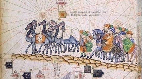
The Southern Silk Road, probably the earliest of all those ancient trading routes and modern tourism icons, like the rest of them across the vast lands of Central Asia, appears to have had many diversions, both major and minor.
The links between the emerging civilisations of the known world, east, west and south, have, especially along that which runs through Central Asia, left many conspicuous landmarks of the wealth that travelled that way. In China, as in Bangladesh and India, too, such traces are not hard to find.
However, water has always been regarded, logically, as the highway of the ancient world, and it is the great rivers of South Asia that have left clues to their early, and extensive use for trade between those emerging civilisations of Europe, Asia, and Africa.
It can be no accident that the earliest maps of the world, such as the Babylonian Imago Mundi of about 600 BCE, indicates three continental parcels of land; or that the map, credited to the Milesian, Anaximander, from about 560BCE, much more clearly reveals this tripartite view of the world. By the time of the map credited to another Milesian, Hecataeus, about 500BCE, he even marks a range of mountains across Asia which it seems reasonable to credit as the Caucasian range, running into the Himalayas, in which a river rises, and runs along the front of the range to the sea, which it seems also reasonable to identify as the Ganges. The facility of mapping such features indicates the long-term age-old, and substantial experience of them.
By the time of Ptolemy’s map of the mid 2nd century CE, which clearly marks a river branching off the Ganges, and passing, northeastwards, through the Himalayan range, we are, with certainty, able to identify the Brahmaputra.
Although the Brahmaputra is, reasonably, supposed to be the main thread of what the Chinese have called the Southern Silk Road, there has always been speculation about how ancient traders have, with ease, made the link from that river, and the subcontinent, to the nascent Yellow River as the main, riverine, route to the great urban centres of prehistoric China.
The Teesta route into Sikkim, and thence to Tibet, was, almost certainly, one such connection; as was the ancient Ledo Road from Assam through Upper Myanmar, to Yunnan. The fact that Ptolemy clearly marked Ramcu, at a location identifiable with today’s Ramu, suggests that, in addition to valley routes towards Mandalay from Sylhet and Chittagong, there were even more easterly routes, including, no doubt, such rivers as the Naf, and the great rivers of modern Burma.
However, it may well be that the missing link in speculation about such key linkages, all of which seem to involve substantial, and necessarily hazardous mountain crossing, to date, could well be the, currently, closely protected and militarised route of the Lohit River. Rising, as it does, in Tibet, and passing through the Himalayas without, apparently, according to the distinguished French archaeologist, Jean-Francois Salles, who has done so much research in Bangladesh in recent decades, ever rising more than 1,000 metres above sea level.
This is one of the two great passes by which, in 1962, China entered Indian territory at the beginning of the Sino-Indian War. It is, however, perhaps the most navigable, by water and by waterside, through the Himalayas.
The Lohit River rises in eastern Tibet, in the Zayal Chu range of mountains, passes through Sichuan Province, and crosses into India at Kibithu. The pass through which the river enters India is in the very north of Arunachal Pradesh, not so far from the northern Myanmar border, flowing on for two hundred kilometres, through into Assam.

In this northern state of India, an ancient part of which is now in Bangladesh, it flows into the waters of the Tsangpo River, also with its origins in Tibet. The joint waters of these two rivers become the famous, holy, “son of Brahma,” the Brahmaputra. Thence, it flows to the lands around the Ganges Delta where its waters meet those of the Ganges and Meghna, forming the world’s largest delta. At the heart of modern Bangladesh.
Here, since ancient times, this diversity of trading routes to the seas around the Delta, have formed one of the world’s earliest and greatest centres of trade. From the delta, water borne trade reached lands, certainly west, by road and river through the Ganges basin, and, by sea, beyond, to East Asia, Arabia, Africa, and Europe. And also, the emerging nations of Southeast Asia.
There was a time when Europe regarded the lands of the eastern Mediterranean as the “cradle of civilisation.” Now, we are having to think again, as such as the Harappan Civilisation, and that of the Ganges Basin, emerge under the archaeologist’s trowel.
The lands where the waters of the Lohit enter India are still populated by a wide diversity of Tibetan Burmese tribal peoples -- ancient peoples with ancient traditions. And this concentration may well have derived, historically, in this remote terrain, from the trade that would have flowed through it, from very ancient times; as early, even, as 10,000 years before the Common Era, considering such possible linkages as the domestication of rice, that appears to have occurred in the fertile valleys of Yunnan and Sichuan, over twelve millennia ago, to be followed by such development in the Ganges Basin within a millennium or so.
Exploration of the terrain, today, is difficult, if not impossible, in view of the military sensitivity of it as a navigable passage between the two great neighbouring, but rival, nations.
Someday, perhaps, archaeological exploration may well reveal more substantial evidence of the vital linkage between emerging empires; thus far, however, it is only the self evident accessibility as a link between the archaeology of prehistoric China with its documentary and archaeological evidence of ancient, transnational trade, and the legendary, documentary and archaeological evidence of the links with the subcontinent, that provide, largely, circumstantial evidence of them.
We may well wonder why India itself is so discrete about the identity, and the history, of this, hitherto, missing link in the consideration of the Southern Silk Road.
However, it seems reasonable to suppose that, since promotion of such an ancient trading route must, inevitably, include Bangladesh as the only realistic port of exit and entry, India has preferred not to mention it.
Perhaps, more charitably, we may also suppose that, militarily, the frontier link is so sensitive that India is reluctant to encourage tourism in the area. Especially, given some of the politically rampant independence movements in the region.
Whatever the reason, it appears that this river, known as “the river of blood,” not only, it seems, for the colour of the laterite, or rust-red from the iron oxide content in its soil, but also, we may assume, from its regular site as a field of conflict, has been, for millennia, the key link between sprawling empires, and rich centres of trade.