Teotihuacan (Mexique): Proyecto Arqueológico Tlajinga Teotihuacan
Boston University
Source - http://sites.bu.edu/patt/
The archaeology of early urbanism provides deep historical context for an increasingly urbanized world. Its study through the Proyecto Arqueológico Tlajinga Teotihuacan (PATT) involves collaborative investigations by an international team of interdisciplinary researchers at the ancient city of Teotihuacan, Mexico. During its height in the early first millennium CE, Teotihuacan was the largest city in the Americas and one of the largest in the world. Today it is a UNESCO World Heritage Site and welcomes millions of visitors every year. Although Teotihuacan has been studied by generations of archaeologists, there is still much we do not know about the city, its rise and fall, and what daily life was like for its many inhabitants. Teotihuacan is famed for its high level of civic planning, cosmopolitan populace, and broad economic reach, but better understanding such issues requires more intensive investigations within understudied portions of the city.
Investigations of the PATT focus on the Tlajinga district, a cluster of neighborhoods in the southern part of the city (map below) that was inhabited by a lower socioeconomic stratum, was the locus of intensive utilitarian craft production, and is bisected by the city’s central artery—named the Street of the Dead by the later Aztecs, who viewed Teotihuacan as a mythical place of origins and an archetypal city. Research goals of the PATT scale from the level of the household to the level of the urbanization of the city as a whole. They include understanding the tempo and processes of urban growth; the dynamics between central civic planning and neighborhoods; and the domestic economy and daily life of the common-status families who resided in the district and represent the urban experience for a majority of the city’s inhabitants.
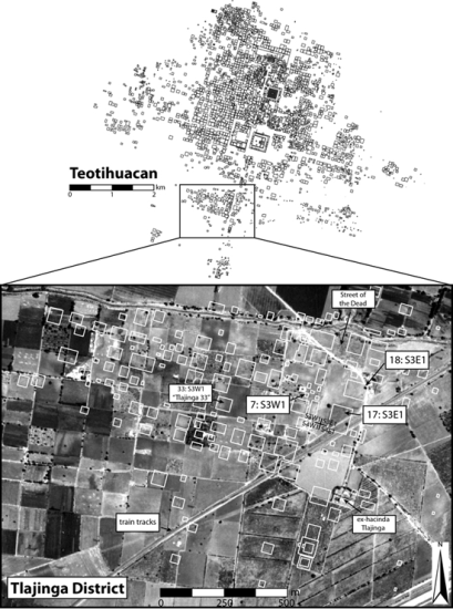 Location of the Tlajinga district at Teotihuacan
Geospatial Research
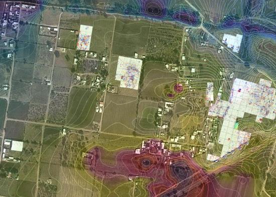 In progress geospatial mapping projects at the Tlajinga district
Archaeologists classify Tlajinga as a district of Teotihuacan because of its presumed administrative functions within the civic hierarchy of the city. Covering approximately a square kilometer with some ninety multi-family apartment compounds, Tlajinga likely housed a population in the low thousands, organized into neighborhoods of frequently interacting residents. Several methods of geospatial research are aimed at understanding district and neighborhood-level organization. The research is being overseen by Luis Barba and the team from the Archaeological Prospection Laboratory at the Universidad Nacional Autónoma de México (UNAM).
A view from above is provided by high-resolution satellite imagery, which we are using principally in two ways: one is to look for linear features in areas south of the city that may correspond to buried canals used in floodwater irrigation; a second is to detect areas of the modern ground surface with white patches that could correspond to concentrations of calcium carbonate as decay product of the lime plaster used to cover more formal floors and structures, and seen more rarely at Tlajinga than at higher-status parts of the city.
On the ground we are using terrestrial methods of remote sensing, including magnetometry, ground-penetrating radar (GPR), and electrical resistivity. Since most of the construction at Teotihuacan used igneous rock, we have found magnetic gradient to be effective in covering large areas in outlining the plans and major interior partitions of compounds. GPR and resistivity, in turn, provide complementary lines of evidence for identifying cultural features and verifying the depths of deposits. Together, these methods provide an understanding of what lies beneath the surface prior to excavation and allows us to gauge variability in the size, spacing, and general organization of apartment compounds.
Household Archaeology
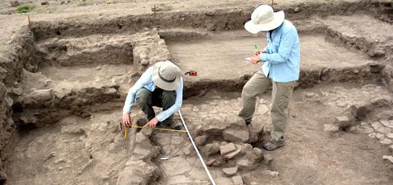 Field illustration at Compound 18:S3E1.
The study of households in the Tlajinga district began in the 1970s, when a team of researchers from Penn State excavated much of a compound designated 33:S3W1 in the Teotihuacan map and known in the literature as Tlajinga 33 (see bibliography for publications from this project). This compound was occupied by families of potters, who specialized in the production of a utilitarian ware called San Martin Orange. Other than a few salvage operations, no other excavations had been undertaken in the district until the PATT.
We have now excavated parts of two other compounds: 17:S3E1 and 18:S3E1. Compound 17 was occupied by individuals who specialized in the production of obsidian blades, the most common cutting tool for Teotihuacan and Classic period Mesoamerica. Compound 18 appears to have been occupied by masons and lapidary specialists. House construction is variable within both compounds. Walls were primarily made from stone, but some were nicely cut blocks while others were made of small stones and rubble. In a few cases walls were made from adobe. A gravel concrete typical at Teotihuacan was frequently used for floors and to dress walls, yet lime plaster is uncommon and was likely reserved for higher-status residences and civic-ceremonial structures. These craft activities and construction techniques help us to place the occupants of the compounds within the mid to lower-status of the city’s socioeconomic spectrum.
Although they were of lower status and living at a distance from the urban epicenter, Tlajinga’s inhabitants were closely integrated into the urban fabric of Teotihuacan. Apartment compounds were oriented to the orthogonal plan of the city and were relatively nicely made. Compounds 17 and 18 featured drains emptying to the Street of the Dead and central courtyards for domestic ritual and other gatherings. The occupants also enjoyed a degree of access to long-distance trade goods—such as greenstone, shell, and mica—and limited quantities of fancy, decorated pottery. Nevertheless, Rebecca Storey documented high rates of infant mortality at Tlajinga 33, similar to those estimated for imperial Rome. Her bioarchaeological study underscores increased disease tolls as one of the detractions of ancient urbanization.
 Aerial photography at Compound 17:S3E1