Stonehenge G-B) was built on a solstice axis but only because of an Ice Age fluke
- Excavations confirm that Stonehenge was built on an Ice Age landform
- Ridges found to point at the mid-winter sunset and mid-summer sunrise
- Experts claim that ancient people believed the geological scars signified the 'union of heaven and earth' at the longest and shortest day of the year
- Evidence has also been found that the now broken circle was once complete
Dalya Alberge
The ancient people who built Stonehenge chose the site in modern-day Wiltshire because of its solar significance, archaeologists claim.
In what is described as a ‘missing piece in the jigsaw’ in our understanding of England’s greatest prehistoric site, excavations confirm the theory that its ancient processional route was built along an ice-age landform which was naturally on the solstice axis, according to Professor Mike Parker Pearson, a leading expert on Stonehenge.
The monument’s original purpose still remains shrouded in mystery, but this is a dramatic clue, he said.

The ancient people who built Stonehenge chose the site in modern-day Wiltshire because of its solar significance, archaeologists claim. In what is described as a 'missing piece in the jigsaw', excavations confirm the theory that its ancient processional route was built along an ice-age landform
The route, known as the Avenue (1), extended 1.5 miles from the standing stones’ north-eastern entrance to West Amesbury. It has been likened to The Mall leading to Buckingham Palace.
After the closure of the A344 road, which bisected the route, archaeologists have been able to excavate there for the first time.
The excavations were conducted by Wessex Archaeology for English Heritage.
Just below the modern road’s surface, they unearthed ditches dug by prehistoric builders.
Professor Parker Pearson identified naturally-occurring fissures that once lay between ridges which follow the route of the Avenue.
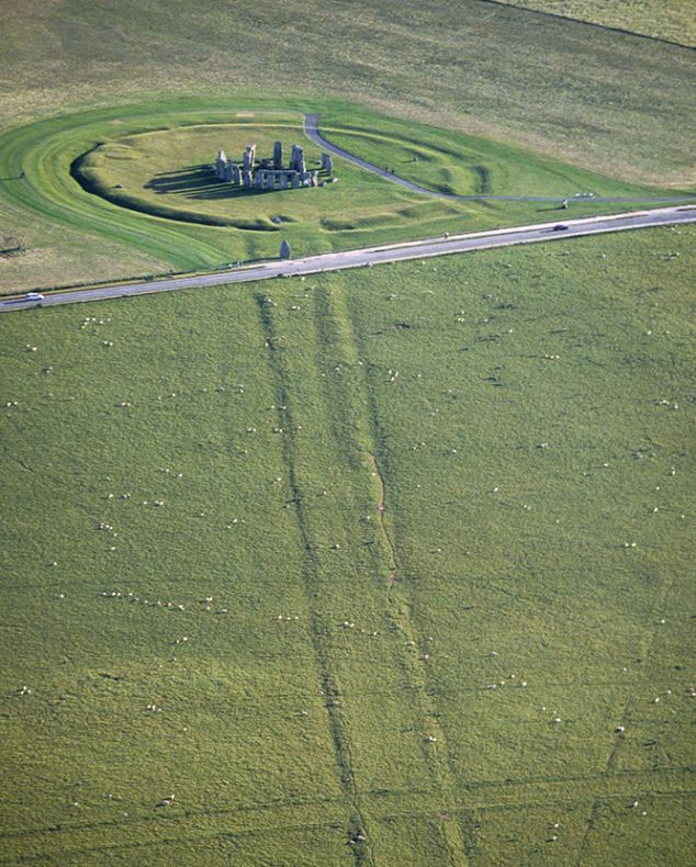
The route, known as the Avenue, extended 1.5 miles from the standing stones north-eastern entrance. After the closure of the A344 (pictured), archaeologists have been able to excavate there for the first time. Professor Parker Pearson identified naturally-occurring fissures that once lay between ridges which follow the route
The ridges were created by Ice Age meltwater and naturally point directly at the mid-winter sunset in one direction and the mid-summer sunrise in the other.
Professer Parker Pearson is excited by the evidence, which he describes as ‘hugely significant’.
‘It tells us a lot about why Stonehenge was located where it is and why they were so interested in the solstices,’ he said.
‘It’s not to do with worshipping the sun, some kind of calendar or astronomical observatory.
‘It’s about how this place was special to prehistoric people. This natural landform happens to be on the solstice axis, which brings heaven and earth into one.’
He explained that Stonehenge is ‘all about the solstices’ and our ancestors could see this in the land.
The excavations support theories that first emerged in 2008 with an exploration of a narrow trench across the Avenue.

The ridges were created by Ice Age meltwater and naturally point directly at the mid-winter sunset in one direction and the mid-summer sunrise in the other
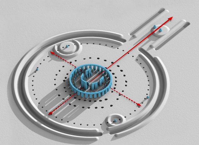
On the central area of the site there are the stone settings (in blue), with the inner circle consisting of a 'sarsen horseshoe'. The outermost element of the site is the Avenue which consists of twin banks about 12m apart with internal ditches. The red lines signify how sunrise aligns with the Avenue
Professor Parker Pearson said: ‘It’s being able to see the big picture.’
Dr Heather Sebire, English Heritage’s Stonehenge curator, said: ‘The part of the Avenue that was cut through by the road has obviously been destroyed forever, but we were hopeful that archaeology below the road would survive.
‘And here we have it – the missing piece in the jigsaw. It is very exciting to find a piece of physical evidence that officially makes the connection which we were hoping for.’
She expects the latest findings to spark vigorous academic debate, and English Heritage has not expressed an opinion on the naturally-formed ridges, their interpretation being confined to the ditches.
The original A344 road is to be grassed over next year as part of English Heritage’s £27m transformation of the World Heritage Site, which draws more than one million annual visitors.
A new visitor centre will be opened, 1.5 miles away out of sight, to allow Stonehenge to reconnect with the surrounding landscape.

Stonehenge's original purpose still remains shrouded in mystery, but the findings of the natural land formation is a dramatic clue behind why it was located in this area
The latest study has also identified three holes where missing stones would have stood on the outer sarsen circle – evidence, it is believed, that the circle was indeed once complete.
Astonishingly, at least to the layman, even the most sophisticated surveys failed to spot them.
Two eagle-eyed members of staff happened to notice dry surface areas of grass, or parchmarks.
Professor Parker Pearson said: ‘The problem is we’ve not had a decent dry summer in many years.
‘Stonehenge is always regularly watered - and the only reason these have shown up is because - for some reason this year - their hose was too short… So we’re very lucky.’
Susan Greaney, an English Heritage historian, added: ‘The discovery… has certainly strengthened the case for [the monument] being a full circle.’
-:-:-:-:-:-:-:
1) Stonehenge Avenue is an ancient avenue marked as a UNESCO World Heritage Site built between 2600 to 1700 BCE.
It has been likened to The Mall leading to Buckingham Palace.
Discovered in the 18th century, it measures nearly 3 kilometres and connects Stonehenge with the River Avon.
The avenue is aligned with the sunrise of the summer solstice, suggesting a time of most frequent use.
At the end of the Avenue, a similar ring of bluestones, Bluestonehenge, was discovered in 2009.
Mike Parker Pearson of the Stonehenge Riverside Project believes the Avenue was inspired by and built over top of a natural glacial formation with an existing astronomical alignment.