South Atlantic Coast (USA): Satellite imagery shows evidence of massive tsunami
Richard Thornton
Source - http://www.examiner.com/article/evidence-of-a-massive-tsunami-on-south-atlantic-coast
Richard Thornton - enhancement of NASA/ERSI satellite imagery
These geological formations suggest that a wall of water, at least 100 feet high, swept into the interior of Georgia. It was at least 70 feet high in northeast Florida. The catastrophic wave could have been much higher.
Residents of the South Atlantic Coastal Plain are accustomed to seeing ridges, terraces and hills, composed of sand and fossilized marine life, deep within the interior of the region. The Trail Ridge is the best known of these sand formations. It runs parallel to and about 40 miles from the Atlantic Coast. The Sand Hills Region runs from near Columbus, GA several hundred miles northward to near Richmond, VA. It can be as far as 180 miles from the coast. Near the Atlantic Coast sandy dunes and terraces that are parallel to the coastline can be as closely spaced as a few hundred yards.
Geologists have traditionally explained these numerous sand formations as the remnants of ancient beaches and islands when ocean levels were much higher. Many actually look like islands within the flat landscape of the Coastal Plain.
Geologists are not as certain about the Trail Ridge. This geological formation appeared long after the ocean had receded to the east. In 2010, Dr. Peter Adams, a geology professor at the University of Florida, postulated that the Trail Ridge was created by an uplift in the bedrocks far beneath the surface, when the weight of water was removed from the now dry land. His computer model estimated that the Trail Ridge was about 1.4 million years old.
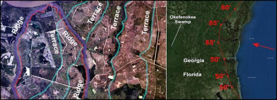
There is another type of geological formation on the South Atlantic Coast that has scarcely been noticed by geologists, or else been lumped into the category of “ancient coastal islands,” without much serious thought. Beginning around Port Royal Sound, SC and continuing southward to St. Augustine, FL are a chain of tall ridges and hills that become increasingly tall and farther from the coast until they it reach the center point of the chain on the Satilla River in southeastern Georgia. Unlike all the other sand formations, these ridges vary from being almost perpendicular to the coastline to diagonal to forming U-shaped enclosures. The highest ones, near Woodbine, Brunswick and Darien, GA are 80-85 feet (+/- 25 m) tall.
A French captain’s observation in 1564
In 1564 French Captain René de Laudonnière became entranced with a hill or ridge that he called “his modest mountain,” while exploring the South Atlantic Coast for a location to establish a colony. The hill was apparently about 10-11 miles inland, since he selected a spot for a fort nearby that was that distance from the ocean. De Laudonnière stated that from the top of the hill, he could see across the broad bay created by the May River to the edge of the ocean. That means that the hill was at least 40 feet high.
Over the past seven years, researchers in the People of One Fire comprehensively studied the South Atlantic Coast in search of the real location of that French colony. The colony was called Fort Caroline. Using infrared and LIDAR imagery provided by the Georgia Coastal Commission in Darien, GA, and also, satellite imagery from the US Geological Survey in Reston, VA, the researchers created a map that showed all hills and ridges along the coast between Jacksonville, FL and Midway, GA that were at least 40 feet high . . . the taller , the better.
A surprising pattern emerged. The tallest hills and bluffs formed an arc that was the shape of part of an ellipse. The tallest hills and ridges were at the head of this ellipse. What was even more surprising was that these highest ridges had no relation to the onion peel patter of marine terraces that parallel the shoreline. In most cases, they crossed over the terraces. They were clearly created after the shoreline retreated eastward.
These high points became centers of Native American and European colonial activities. Those adjoining rivers were sites for forts during the 1700s and 1800s. St. Johns Bluff at Jacksonville, FL is 50 feet high and about six miles from the Atlantic. Rose’s Bluff in Nassau County, FL is 50 feet high and 8.8 miles from the Atlantic. St. Marys (GA) Ridge is 60 feet high and 9 miles from the Atlantic. Satilla Bluff is 85 feet high and 15-16.6 miles from the Atlantic. Little Satilla Bluff is 85 feet high and 14-15.5 miles from the Atlantic. “The Ridge” near Darien, GA is 80 feet high and 10.5 -13 miles from the Atlantic.
As can be seen in the infrared image above, many of the ridge patterns are very different than the vestiges of high ocean levels. Individual sections of these relatively high bluffs and ridges are identical to that of the impact of the 2005 tsunami on the coastal region of northwestern Sumatra and the 2011 Tōhoku tsunami on the coastal region of northeastern Japan. Both of these tsunamis were caused by earthquakes under the ocean. The debris pile left by retreating waters left ridges of sand, muck, vehicles, houses and trees.
On the other hand, there was something very different about the overall pattern of these ridges on the South Atlantic Coast. Some massive force had pushed sediments from the bottom of the ocean over 10 miles farther inland near Woodbine, GA than at Jacksonville. The alluvial pile was also 90% higher near Woodbine and 10.5 miles farther inland. Woodbine, GA is 50 miles north of Jacksonville. This suggests a “point source” for the tsunami rather than the linear source that is typical of under ocean landslides and earthquakes.
The curvilinear pattern of the high ridges on the South Atlantic Coast most closely resembled the impact of an artillery shell on mud. The impact crater forms an ellipse, with the highest walls of mud kicked up on the side of the ellipse that marks the direction of the artillery shell’s flight. A massive “artillery shell” from space had struck the Atlantic Ocean at an acute angle.
Catastrophes dispatched from outer space
The best known impact event in the Atlantic Region is the asteroid or comet that struck the Gulf of Mexico near the Yucatan Peninsula around 65 million years ago. The Chicxulub meteor would have created a mega-tsunami that was perhaps several hundred feet high when it struck Florida. However, the ocean covered much of southeastern Georgia and northeastern Florida at that time. This monster probably did not create the South Atlantic ridges.
In recent years, geologists have been studying two documented impact events in the North Atlantic Ocean. A comet or a cluster of comet fragments struck the North Atlantic on September 28, 1014 AD. Although at least 30,000 people were killed by the resulting tsunami in northwestern Europe, evidence suggests that it struck much closer to New England in North America. Comet debris was splattered inland in New York State.
In 2009, Dallas Abbot of Columbia University found nodules associated with a major asteroid or comet strike at the “500s AD level” of the Greenland Ice Shelf. She insisted that either a comet or asteroid played a role in the climatic catastrophe. In 2010 a Greek archaeologist, Dr. Amand Laoupi, reinforced Abbot’s theories by revealing a second ammonia spike in the Arctic ice shelf in 539 AD. Both researchers think that this comet struck somewhere in the northern Caribbean Sea, perhaps near the Bahama or Puerto Rico. .
Extend a line from the centroid of the ellipse-shaped pattern created by the high ridges on the South Atlantic Coast, and one goes across the eastern Bahamas and Puerto Rico. However, the two scientists were speculating somewhat on the impact site of the 539 AD comet. It may have struck much closer to the South Atlantic Coast. It certainly was headed toward the South Atlantic Coast. Secondary “splatters” of ocean sediment would have created lower hills, both farther inland and closer to the coast. It is also possible that an earlier comet or meteor strike caused the debris rim on the South Atlantic Coast.
For a tsunami to create a debris rim that is up to 85 feet high today suggests that the wall of water was at least 100 feet high. It is quite possible that the wall of water could have been 200 to 300 feet high, maybe even 500 feet. It would have temporarily flooded most of the Coastal Plain in southeastern Georgia and northeastern Florida, killing most humans and terrestrial animals in its path.
A violent tsunami would explain why what were once two long islands off the coast of northeast Florida are now attached to land near St. Augustine. The St. Johns River and St. Augustine Bay are the vestiges of an ocean channel that once separated these islands from the Florida Peninsula.
Early European explorers encountered large lakes within the interior of South Carolina and Georgia along major rivers. The best known of these are Lake Ashley in South Carolina and Lake Tama in Georgia. Most of these lakes are now smaller swamps that are no longer labeled as lakes on maps. If the comet impact occurred as recently as 539 AD, these enigmatic lakes could have been created by debris dams on the rivers. Over time the lakes would have drained out.
Aside from her little temper fits with tornadoes and hurricanes, Mother Nature seems rather calm and benign in Eastern North America. However, such little hints as the 85 feet high sand ridges on the South Atlantic Coast are reminders that she is quite capable of playing “gotcha” without any notice.