Perry Mesa (USA): A lost civilization may shed light on coping with climate change
A LOST CIVILIZATION MAY SHED LIGHT ON COPING WITH CLIMATE CHANGE
AN INNOVATIVE COLLABORATION BETWEEN SCIENTISTS IS DISCOVERING HOW, 700 YEARS AGO, A MYSTERIOUS, PREHISTORIC CULTURE OVERCAME ITS LANDSCAPE’S HARSH CONSTRAINTS. THE FINDINGS MAY TELL A CAUTIONARY TALE FOR TODAY’S SOUTHWEST.
KEITH KLOOR / PHOTOGRAPHY MARK KLETT

Imagine a science in which discoveries are made after a bulldozer digs up the ground for a new highway, oil pipeline, or strip mall. That’s the way most archaeological sites are unearthed today, particularly in the booming Southwest. “The vast majority of information about prehistoric people is learned this way,” says Rick Moore, an associate director with the Grand Canyon Trust, an Arizona-based conservation group that has incorporated archaeology into its mission. For example, in Phoenix, which is sprawling ever faster across the Sonoran Desert, 700-year-old remnants of the ancient Hohokam settlement—everything from farming tools to subterranean pit houses—are still routinely found.
Similar evidence of other lost cultures turns up frequently all over the Southwest. The ruins—sometimes whole villages—are remarkably well preserved by the region’s dry climate and often still largely intact, at least until the latest highway widening. Scientists have grown accustomed to working one step ahead of the bulldozer. “Where there is destruction of the landscape, you’ll find archaeologists,” says Steve Simms, an archaeologist at Utah State University. “We’re like morticians of the environment.”
Ecologists, who also are called to action when a species is at death’s door, have the Endangered Species Act (ESA) to help them ward off extinction. The federal law can be invoked to prevent the last remaining habitat of an imperiled animal or plant from being converted into a casino or condominium development. Archaeologists have the National Historic Preservation Act to at least help them slow the backhoes. To mitigate potential damages, they get a short reprieve to document or excavate the ruins before they’re lost forever.
For both wildlife and archaeology, one of the best refuges has long been public lands, as President Bill Clinton decreed when he began establishing national monuments in the mid-1990s specifically for their ecological and archaeological value. He distinguished these monuments as scientific havens and eventually grouped them into a special classification within the Bureau of Land Management (BLM) called the National Landscape Conservation System. (There are more than 100 national monuments, most of them managed by the National Park Service.) This novel breed of BLM monuments soon prompted a number of ecologists and archaeologists to step out of their separate universes and join forces.
Today that newfound familiarity has bloomed into a pioneering, collaborative venture at Agua Fria National Monument, a mosaic of canyons, mesa tops, and grasslands located in a sparsely populated, mountainous region of central Arizona. President Clinton created the monument in 2000, based largely on its 450 known prehistoric sites, which include an unusual assortment of multi-room houses made of mud and stone (known as pueblos) perched on a rocky mesa. There archaeologists and ecologists from Arizona State University (ASU) are studying the age-old ruins and the ecosystem surrounding them. The project, started in 2003 and called Legacies on the Landscape, is now yielding surprising insights about the people who lived there 700 years ago, as well as about the long-term ecological changes they wrought on the land.
Additionally, the research sheds new light on a volatile period in the Southwest, when prehistoric cultures were forced to adapt to unpredictable climate changes. Some scientists believe that the stage is being set for similar environmental conditions today, as the region contends with explosive development, cyclical droughts, and rapid water depletion. In some circles there’s even a school of thought, argued recently in Jared Diamond’s best-selling Collapse: How Societies Choose to Fail or Succeed, that the current rate of population growth and environmental exploitation in the Southwest is about to collide with harsher climatic conditions in ways that may soon mirror what occurred across the region in the 13th century, which archaeologists consider a period of tremendous societal upheaval. This also happens to be the time when people started moving into the forbidding, isolated moonscape that now comprises Agua Fria National Monument.
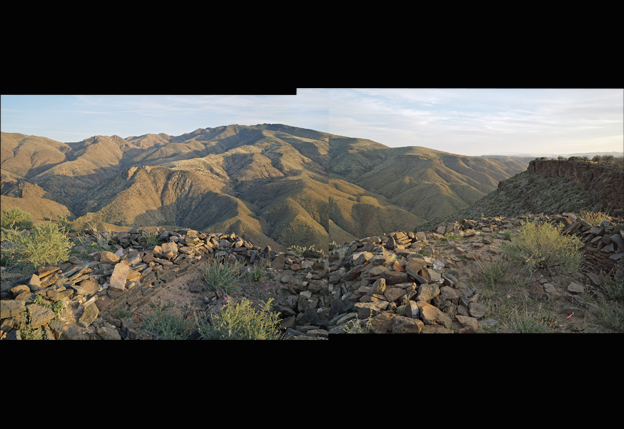
Perry Mesa, a rolling, high-desert landscape within the 71,000-acre monument, is only 40 miles north of Phoenix, but it is so remote and stretches so far toward the horizon that it might as well be the end of the earth. The monument’s entrance lies just off a lonely stretch of Interstate 17. There, a winding gravel road descends three miles to the Agua Fria River before climbing through narrow valleys and grassy hills to the top of Perry Mesa, 3,500 feet above sea level.
Steep, 1,000-foot canyons cut the mesa. Right here, along several edges, sit a number of hollowed-out pueblos, some with 50 to 70 rooms. The people of Perry Mesa started constructing this settlement around 1275, stayed for most of the 1300s, and then suddenly vanished into history. The only remaining tangible clues, it would seem, are crumbling masonry walls, pottery and other artifacts excavated from the ruins, and the many rock-art images pecked onto cliff faces, including those of bighorn sheep, deer, and bizarre geometric designs.
Until recently, scientists familiar with the archaeological sites had speculated that the former inhabitants moved to Perry Mesa out of desperation. A drought lasting decades rocked much of the Southwest in the 1200s, setting off a fierce scramble for dwindling food resources. During this dark period, many populations moved away from valleys to upland areas, where larger groups clustered together in defensive-oriented settings. The most famous example—still widely debated—is that of the Anasazi, a sophisticated culture in the Four Corners area that had built an impressive network of farming villages over hundreds of years before abandoning them, beginning in the mid-1200s, for precarious cliff-top dwellings.
The case of Perry Mesa is no less befuddling, if not nearly as well known. When I visited there last spring, I had a hard time imagining how anyone could survive the harsh conditions for a month, much less decades. The 75-square-mile tract has a post-apocalyptic, Planet of the Apes aura. Wind whips constantly. Walking is arduous; the terrain, uplifted atop a bed of volcanic rock, is strewn with broken boulders. Thick masses of thorny mesquite and prickly pear cactus hug the brownish ground, which also sprouts patches of frail tobosa grass.
When Hoski Schaafsma starts describing the ancient gardens that once blanketed the landscape, I stare at the dirt in disbelief. All I can make out is a gray, rocky jumble. But Schaafsma, a pony-tailed ASU plant biologist, has in the past few years decoded an astonishing pattern of land use atop Perry Mesa. “This whole hillside is terraced,” he says, sweeping his arm across a lumpy area of the mesa. “What we’re standing on here, this sort of linear clump of rocks, is drainage, where they were catching the water and soils for agricultural purposes.” What appears, at first blush, to be a random assortment of large stones are actually the remnants of an intricate network of irrigation and cultivated farm fields.
Seven centuries ago rocks were moved and positioned in a way to create walls perpendicular to a given slope so that they caught water and soil after monsoonal rains. Some of the surface soil at Perry Mesa is sandy, which is not the best for farming. But the manipulation of rocks into a series of walls that form terraces engineered a loam for maximum agricultural productivity.
The people of Perry Mesa thus teased corn, beans, and agave from a marginal environment—relying only on rainwater. The technique, known as dry farming, was perfected by prehistoric Indians in the hot, arid Southwest. But the extent to which it was practiced seven centuries ago on this bleak terrain has proven revelatory.
Even seasoned archaeologists who have spent years studying Perry Mesa admit to being surprised by the vast agricultural footprint. “If you walk across the landscape and all you’re looking for is stone houses, then that’s all you’ll find,” says Schaafsma, who had an archaeology background before expanding his portfolio with academic training in ecology. To date, he and his colleagues have documented about 1,000 terraces, with many more expected. As Rem Hawes, manager of Agua Fria National Monument, puts it, Perry Mesa’s “entire landscape was intensively managed to control and collect water, grow crops, and support a thriving society.”
In doing so the indigenous inhabitants—whose descendants are thought by some to be the Hopi, a tribe that still practices dry farming in northern Arizona—totally changed the composition of the soil and altered the plant community, a legacy that continues today. “These people [on Perry Mesa] essentially created their own unique ecosystem,” marvels Connie Stone, a BLM archaeologist who advises on the management of the monument.
How a prehistoric culture transformed this inhospitable environment is just becoming clear, but the most obvious questions still mystify scientists. “Why did they move up there, and why did they leave?” asks Jeffery Clark, an archaeologist with the Tucson-based Center for Desert Archaeology.