Paphos (Chypre): Archaeologists know more about the ancient capital
PAP - Science and Scholarship in Poland
 This year's excavations. Photo by Robert Słaboński
Hellenistic and Roman Agora and economic infrastructure of the ancient capital of Cyprus – Paphos are the subjects of a comprehensive research project of Polish scientists. Researchers are also on the trail of a lost, ancient port.
"This year, a record number of 70 people were involved in our research, due to an arsenal of research methods and massive scale of our activities" - explained Prof. Ewdoksia Papuci-Władyka, Head of the Department of Classical Archaeology at the Jagiellonian University Institute of Archaeology, leader of the Paphos Agora Project.
Excavations concentrated within the ancient agora, which used to be the central square of the city. Archaeologists unveiled further parts the remains of buildings discovered last year, interpreted as a temple and a storage building. Both were built probably in the late fourth century BC. In the case of the former, so far they discovered a wall whose length exceeds 16 meters - the building is therefore larger than previously thought.
"In the southern part of the Agora, in turn, we came across the beautiful marble Corinthian capital of a column, which was probably at the entrance to the square" - added Prof. Papuci-Władyka.
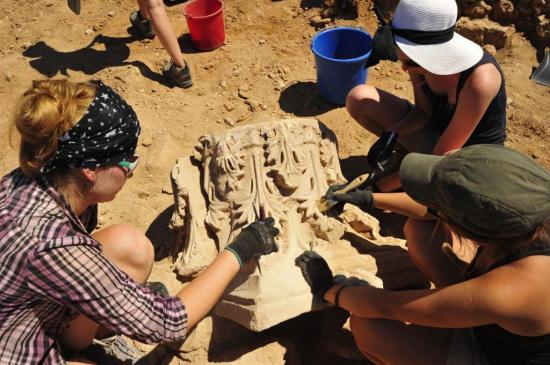 Cleaning the discovered Corinthian capital. Photo by Robert Słaboński
The discovery was made in the excavation studied last year. However, in the archaeological excavation newly opened this year, located at the corner of the Agora, in addition to architectural elements there were also many fragments of pottery, and even an amphora for wine preserved in its entirety. "We have also found many other items, but the most important are the remains of horse harness made of bronze. This find is very rare in Cyprus" - said the expedition leader.
The ancient capital of Cyprus research project entered a new phase with obtaining the NCN Maestro grant, which includes not only further work in the agora, but also beyond it. Scientists plan to survey the ancient city’s economic infrastructure, which is located within the Archaeological Park; Nea Paphos is one of the main attractions of Cyprus. For this purpose, they will use a number of non-invasive methods. The challenge is a very large area of research - approx. 75 hectares, which is roughly 70 percent area of the ancient city.
"Our goal is to understand how the public space of the agora functioned. We'll also look at Paphos economic system in the Hellenistic-Roman period, in the broad context of the Eastern Mediterranean basin" - explained Prof. Papuci-Władyka.
To achieve the goal, in addition to archaeologists, architects, surveyors, geophysicists, geographers and conservators are also involved in the project. The leader of the expedition particularly praises and expects good results of the application of geophysical methods, used by invited specialists from the University of Hamburg. Using a magnetometer, they have located an interesting structure adjacent to the excavated alleged temple. Next year, in addition to the magnetometer, scientists will use a ground penetrating radar - all on a broader scale in comparison to this, preliminary season. The results will be verified with small archaeological excavations.
 Scanning one of the excavations. Photo by Robert Słaboński
Three other groups of specialists also worked at the site this season. Surveyors prepared an extended geodetic control network for the non-invasive geophysical surveys, covering the entire Archaeological Park. Moreover they assisted the archaeologists with the documentation of discoveries during excavations. A group of specialists from Kraków's AGH made 3D scanning of layers and relics excavated this year using Faro-Focus. They also tested the possibility of using the scanner to document the various stages of exploration of archaeological layers. The researchers compared this method of documentation with close-range photogrammetry done with a camera suspended on a drone.
"Ultimately we decided that photogrammetry allows to achieve a sufficiently good image in significantly less time compared to scanning" - reported Prof. Papuci-Władyka.
Unsolved problem when using close range photogrammetry remains ... the uneven fight with the sun. Unfortunately, in the area of the Mediterranean the sun is exceptionally strong during the day - light conditions for documenting the findings - archaeological layers are unfavourable and cause that the colour layer are not documented properly. And colour differences between layers allow archaeologists to understand what processes occurred in the study area - what structures existed there, what was happening in them and how they were destroyed.
"Solving this problem will be one of the main tasks for the next year" - said the archaeologist.
Modern technologies are used in Paphos for specific scientific purposes, and not for creating "pretty pictures". Specialists from the Jagiellonian University and Warsaw University of Technology have processed the images taken by the drone to prepare a Digital Terrain Model (DTM), three-dimensional model of the whole area of the Park. The most interesting observations were made in the north-western part of the city.
"We want to test the hypothesis of the existence of another port in Paphos. The main port was the one located in the southern part of the city. Preliminary analysis of the acquired material revealed the existence of outlines of ancient buildings next to the coastline - it could be docks or warehouses of the lost port" - the scientist speculated.
Geoarchaeological research should also contribute to clarifying the issue of the possible existence of the second port and many other issues associated with environmental changes in Paphos. It was conducted by another group of specialists, this time from the University of Kielce. The analyses showed, among other things, that the sediments carried by two rivers (Koskinos and Ezousas), the valleys of which have an outlet in the area, mudded the area and caused changes in the coastline.
"This could be the reason why earlier underwater research carried out in search of traces of the port did not yield results. We want to verify this and already have the first results" - concluded Prof. Papuci-Władyka.
This year's research was conducted in August and September. The project is under the patronage of the Polish Embassy in Nicosia.