ARCHEOLOG-HOME / INDIana-UNIversitas
Contact


Nieszawa (Pologne): second season of research
PAP - Science and Scholarship in Poland
3D reconstruction of the medieval Nieszawa, based on non-invasive studies 2012-13, view of the town square. Authors: Zakrzewski, Wroniecki, Jaworski, Pisz, Rzeźnik
As a result of one of the largest non-invasive studies conducted in Poland to date, including magnetic tests, archaeologists have learned a number of previously unknown details about medieval city existing for just a few decades, relics of which are now located in the Kojawsko-Pomorskie province.
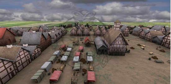
According to the archaeologists, the central point of the medieval Nieszawa was a large square measuring 140 to 140 m and surrounding buildings. These probably included the town hall, stalls and the town scales. In the western side of the city, at a distance of one building quarter, there is a space characterized by a lack of development - perhaps a market square was located there. From the town square, to the south, east and west led parallel road coming out of the corners of the square, forming transport axes of the city. Among them were plots where archaeologists found traces of buildings. Plots had rectangular outlines, and the system was probably dense due to the need for maximum utilization of available space. Furthermore, on the basis of previous excavations archaeologists established that the buildings were half-timbered structures.

3D reconstruction of the medieval Nieszawa, based on non-invasive studies 2012-13, diagonal view. Authors: Zakrzewski, Wroniecki, Jaworski, Pisz, Rzeźnik
A surprising discovery for the scientists was capturing evidence indicating the existence of fortifications from the west and south, forming the image of a compact work of fortification, probably earth structure surrounding the city. Unfortunately we were unable to determine its reach around the perimeter. However, they preliminarily determined locations of town gates.

Artistic vision of Nieszawa square. Author: A. Mieczkowska
According to the researchers Nieszawa had a population of several thousand people. The town was densely built up, with a huge square, clearly defined boroughs, regular street layout, trade and manufacturing areas and a system of earth and water fortifications in the protective shade of the Dybów Castle.
Recreating the image of the medieval city was possible with using a variety of methods. In addition to air prospecting and photography and laser scanning using LiDAR, archaeologists also used various models of radio-controlled drones, which allowed to record and document the entire area of the site of the medieval city. The novelty was the use of a thermal imaging method, which allowed to record thermal traits overlapping with geophysical anomalies. The researchers used a method of measuring the distribution of the magnetic susceptibility of soil on a large scale. 4ha area covered by these measurements provided information on the distribution of human activity zones in the past.

Remotely controlled multicopter in the air. Author: S. Rzeźnik
All results have been integrated in a spatial information system using open source software QGIS. This allowed to build a complex, multi-level database, which was used to create a hypothetical image of medieval Nieszawa, based on both archaeological analogies and historical knowledge. After consulting with medieval city experts: Dr. Jerzy Sikora from the Institute of Archaeology of the University of Łódź and Dr. Michał Starski from the Institute of Archaeology, University of Warsaw, another 3D visualization of the old Nieszawa was prepared (http://www.youtube.com/watch?v=CdAh74ItuA4), based on the latest research. According to the researchers, the model and reconstruction are theoretical and while they are based on sources and analogies, they constitute a field for discussion on the final shape of the medieval city.
History of the city of Nieszawa, founded on the bank of the Vistula opposite to Toruń, is connected with the Dybów Castle built in the fifteenth century by Władysław Jagiello (1424-1428). Settlements quickly began to emerge around the fortress. In 1425, one of these settlements obtained city rights and was named Nowa Nieszawa. In a short time, it became a competitor to the neighboring Toruń, which was lying in the state of Teutonic Knights.
After Toruń townspeople rebellion against the authority of the Teutonic Knights and for their merits in the Thirteen Years' War, King Casimir IV granted privileges ordering the destruction of the competitive economic centre. The king decided to translocate Nieszawa about 32 km up the Vistula, where Nieszawa is today. The site of the second Nieszawa has never been rebuilt, and the last remaining structure (St . Nicholas church) survived until the 18th century. This allows scientists to analyse the medieval city and its layout without major obstacles, as its relics are located in cultivated fields. Until 2012, the precise location of Nieszawa remained unclear, and the approximate location of the city based on long-term air prospection of the left bank of the Vistula made by Wiesław Stepien in the years 2001-2011. Then, in the two-year project funded by the Ministry of Culture and National Heritage ( Cultural Heritage - Protection of archaeological sites) researchers were able to dot the i.
Research in 2013 was performed by the team composed of Wiesław Stępień, Piotr Wroniecki, Marcin Jaworski, Michał Pisz and Stanisław Rzeźnik. The results are available on the official website of the project: http://staranieszawa.pl/