ARCHEOLOG-HOME / INDIana-UNIversitas
Contact


Nasca (Pérou): NASA Airborne Radar ‘Sees’ Nasca Lines
Source - http://www.sci-news.com/archaeology/nasa-airborne-radar-nasca-lines-03600.html
NASA’s Uninhabited Aerial Vehicle Synthetic Aperture Radar (UAVSAR), an airborne radar developed by the Jet Propulsion Laboratory in Pasadena, proved it could pinpoint areas of disturbance in the famed and enigmaticNasca lines, Peru.
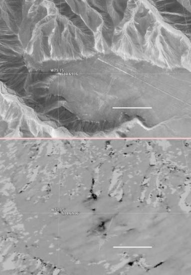 The hummingbird glyph and its surroundings in the Nasca site as seen by standard photography, top, and by NASA’s UAVSAR radar. Dark areas in the UAVSAR image are where the site has been disturbed. Image credit: Google, Digital Globe / NASA / JPL-Caltech.
According to NASA, “UAVSAR is an airborne radar used to study earthquakes, volcanoes, vegetation, hydrology, ice, and other Earth features.”
The instrument currently ‘flies on a NASA C-20A piloted aircraft. When flown over the same area multiple times, UAVSAR is uniquely designed to see how the area changes.”
“The Precision Autopilot controls the airplane so that it can fly the same path within 33 feet (10 m). Using the technique of radar interferometry, two UAVSAR images of the same area can be differenced to show the changes between the images.”
Bruce Chapman of the Jet Propulsion Laboratory said: “UAVSAR is ideally suited for observing the Nasca site because the region has virtually no vegetation and receives no rainfall whatsoever in most years, meaning that natural disturbances are minimal.”
The data collected by UAVSAR in Peru will help authorities fully catalog the thousand-year-old designs drawn on the ground in and around the Nasca site for the first time, as well as giving them a new tool for protecting the fragile constructions from both careless humans and natural disturbances such as floods.
The top frame shows a portion of the mesa-top site in a Google Earth image. Drainage gullies circle the mesa where the Nasca people constructed lines several miles long, enormous polygons, and animal figures simply by moving rocks.
A shape called the Hummingbird is faintly visible above and to the left of the scale line, its long beak ending below a road that cuts diagonally from the right edge of the image to the center.
In the synthetic aperture radar image of the same site, below, areas of disturbance appear dark.
There are extensive areas of disturbance around the Hummingbird as well as a pathway down the gully directly above the glyph.
Other small disturbances may have been caused by erosion in the dry creekbeds.
This and other UAVSAR images of the Nasca site will be published in the journal Conservation and Management of Archaeological Sites.