ARCHEOLOG-HOME / INDIana-UNIversitas
Contact


Mynydd Y Betws (G-B): The first 8 vital questions (of 18)
The first 8 vital questions (of 18) about Mynydd Y Betws
Sandy Gerrard
Source - http://heritageaction.wordpress.com/
18 vital questions regarding the construction of a windfarm on the Mynydd Y Betws archaeological landscape are yet to be answered. Here are the first eight:
Background:
On the slopes of Bancbryn (forming part of Mynydd Y Betws) there is an incredibly rich multi-period archaeological landscape the importance of which has in part been recognised by Cadw’s designation regime. To all intents and purposes this looks like an important ceremonial/ritual landscape with a stone row forming its focus. The hillside is further enhanced by the survival of a range of historic features highlighting the importance of the area in more recent years. This impressive landscape now has a large road cutting right through its heart and shortly will have two substantial wind turbines towering 110m above it. The setting of this significant landscape will be compromised for years to come and even after the turbines have been The first 8 vital questions (of 18)dismantled the archaeology lost in their construction will be gone for ever. It is just not possible to replace archaeology once it has been destroyed and for this reason and quite rightly so there are legal constraints in place to ensure that archaeology is recorded before it is destroyed. This has not happened at Mynydd Y Betws and it is therefore surely appropriate that an explanation of this lamentable situation is forthcoming. To provide a focus I would suggest that answers to the following questions are needed:
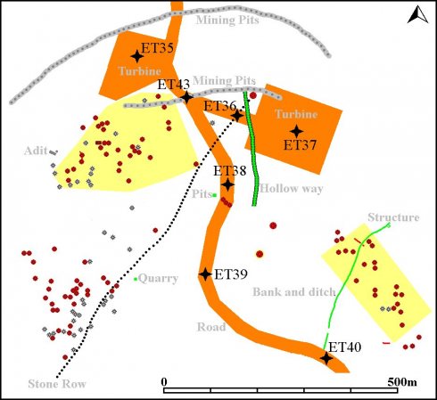
Question 1. Why was no earthwork survey ever conducted?
If this work had been carried out the archaeological remains of many periods would not have been destroyed before they could be recorded. The Planning Inspector observed that there was unrecorded archaeology within the development area and despite this no measures were taken to remedy the situation. The plan below is an unofficial survey of the archaeology and evaluation trenches. It took 2 days to produce and on many levels is more informative than the evaluation work carried out as part of the planning conditions. A survey of this type would have provided a context for the archaeology within the development area and allowed a properly targeted and effective mitigation exercise.
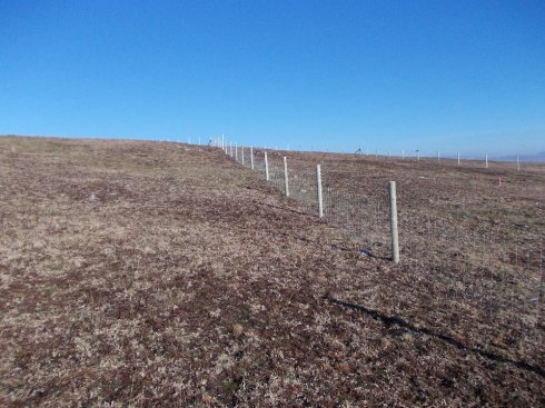
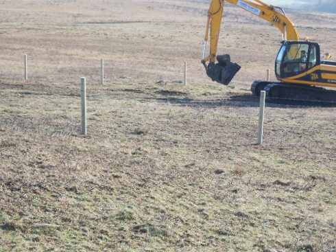
Question 2. Why was no watching brief carried out when a fence was erected on the very edge of a scheduled monument (see image below)?
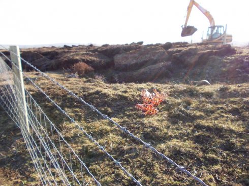
Question 3. Why was no archaeological watching brief being conducted on 16 th January 2012 when a large digging machine was removing topsoil adjacent to a scheduled monument (see image below)?
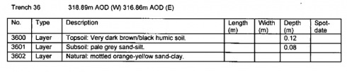
Question 4. Why despite the fact that Evaluation Trench 36 (see below) was cut straight across the stone row was the stone row not identified?
 Question 5. Was the possibility of protecting the row below the new road even considered?
At Rotherwas, near Hereford, English Heritage insisted that the Rotherwas Ribbon, a linear feature (see below) of unknown significance be protected in this manner when a road was built, thus preserving it in situ…..
Question 6. Why was no evaluation trench placed across the obvious linear hollow labelled on the map as a hollow way (see below)?
Given that a length of this earthwork was going to be destroyed by the new access road why was no trench actually placed across this very obvious earthwork and instead positioned on apparently level ground next to it? Why was this very obvious archaeological feature within the permitted development area ignored by the evaluation report? Does not this oversight confirms that the evaluation was not carried out to adequate standards, as graphically illustrated by the fact that most of the feature within this photograph was subsequently destroyed?

Question 7. Why was no evaluation trench placed across the three cairn-like features between Evaluation Trenches 38 and 39?
The photograph below shows a probable cairn partly within the permitted development area below the bucket of the digger. This feature was not located during the archaeological mitigation works.
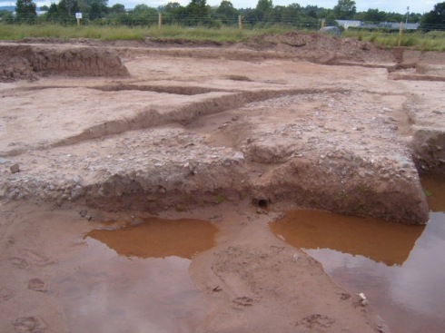
Question 8. Why was the bank with associated ditch near to Evaluation Trench 40 not examined and why was the trench not excavated on the site of the earthworks? The feature has now been cut through by the road and is clearly visible in the section formed by the newly constructed road ditch – see below.

…… whereas the surviving ditch and associated bank can still be seen beyond the permitted development area (see below):

The remaining 10 questions will be published shortly but the following comments are relevant to them all:
Three main agencies are involved in this matter and some of the questions are more pertinent to Carmarthenshire County Council than others. However, as the authority responsible for firstly approving the scheme of works and more importantly for discharging the planning condition it is clearly justifiable for the public on whose part they are acting to ask why so much of the archaeology has been ignored in the process. Nowhere does it say that most of the archaeology should be disregarded or ignored, but sadly this is clearly what has happened and an explanation would in the circumstances seem appropriate.