ARCHEOLOG-HOME / INDIana-UNIversitas
Contact


"Lost" New England Revealed by High-Tech Archaeology
Dan Vergano / Katharine M.Johnson and William B.Ouimet, University of Connecticut
USDA Natural Resources ConservationService, Connecticut Environmental Conditions Online
Source - http://news.nationalgeographic.com/news/2014/01/140103-new-england-archaeology-lidar-science/
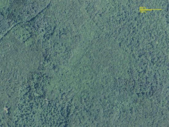
Photo
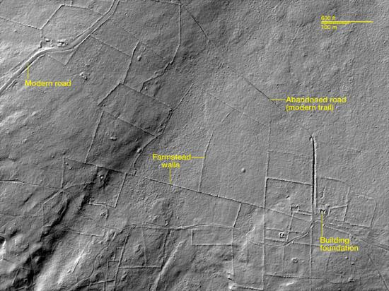
LiDAR
New England's woody hills and dales hide a secret—they weren't always forested. Instead, many were once covered with colonial roads and farmsteads.
This "lost" New England of the colonial era has started to emerge, thanks to archaeologists piercing the forests with the latest in high-tech scanners, called light detection and ranging (LiDAR). In the images above, LiDAR reveals farm walls, roads and homesteads hidden within Connecticut's Pachaug State Forest. Dating to the 18th Century, the farmsteads were abandoned in the 1950's.
The airborne technology bounces laser light pulses off the ground to generate precise pictures of surface features. A quiet revolution in archaeology has resulted from LiDAR's advent, with scholars making new discoveries by using the technology to look at Maya cities,Stonehenge's plains, and Renaissance palaces, among other places.
To find out more, National Geographic spoke with Katharine Johnson of the University of Connecticut, co-author of a Journal of Archaeological Science study, about her research, which used LiDAR to reveal "numerous archaeological sites" in three areas of Connecticut and Massachusetts—the landscape made famous by some of North America's earliest European settlers.
What made you want to look for a "lost" New England?
I grew up in Rhode Island, and as a kid playing in the woods we all knew there were these stone walls and building foundations that were abandoned. They had a mystical, historical quality to them.
I've done a lot of applied archaeology in the region and knew there were a lot of sites that don't appear in historical records. With LiDAR becoming available through a [U.S. Department of Agriculture] survey in New England, it seemed worth looking.
How did parts of New England become "lost" anyway?
A great deal of New England is now forested, and a lot of people don't know it wasn't always that way. There was a lot of subsistence farming across New England, but with industrialization and people heading west to farm, people abandoned these homesteads and the forests started covering everything.
What's so great about LiDAR?
Similar to seeing Maya pyramids emerging from the forest, we can see sites that we couldn't any other way. I literally walk into the woods with GPS coordinates from LiDAR and find a foundation I would never have imagined was there.
Before, we only had ten-foot [three-meter] resolution with LiDAR, but we are able to show now with 1-meter [3.2-foot] resolution that we can detect walls, roads, and other features. We can actually see them under the trees.
What are the limitations?
Native Americans didn't leave behind walls and foundations in New England. LiDAR can't tell us as much directly about their era. We can look for sites where they may have left a mark on the landscape.
One other thing we are demonstrating is that this works well with historical records. You can show that boundaries we are still living with today actually date to the 1700s in some towns and places.
How much potential do you see in LiDAR?
It's amazing trying to compare the difference with the things we found. Walk out to the middle of part of a forest and you would have no idea this was once a cornfield.
With LiDAR we can actually do area surveys that show comprehensively what was once there, not just what has turned up randomly over time. A lot of people don't realize that there has been a lost cultural frontier in New England that we are only discovering now.
Can you imagine a Maya archaeologist looking at your LiDAR readings and speculating on the "collapse" of New England's civilization?
Well, it wasn't such a dramatic collapse. But it certainly would be near and dear to an honest understanding of the population change in New England from 1770 to 1930.
We certainly understand it a lot better than the Maya, but it is remarkable that in northeastern Connecticut we can see some old roads in the woods that were once whole neighborhoods [and are now] just abandoned.
This interview has been edited and condensed.