ARCHEOLOG-HOME / INDIana-UNIversitas
Contact


Liangzhu (Chine): Searching for a Lost Civilization
Liu Bin / Zhejiang Institute of Cultural Heritage and Archaeology
Source - http://www.kaogu.cn/en/detail.asp?ProductID=4384
Liangzhu Culture sites, dated to circa 3300-2300 BCE, are mainly distributed through the Lower Yangtze River Delta around Taihu Lake. Initial excavations within the vicinity of Liangzhu Town in Yuhang District, Zhejiang Province, were conducted by Shi Xingeng in 1936. Since the 1950s, other typical sites have been discovered in Zhejiang, Jiangsu and Shanghai, offering more substantial information about this culture, which was named in 1959 by Xia Nai as “Liangzhu Culture”. Research into this culture was taken to new heights when in the 1980s, many large burials with copious amounts of jade were unearthed around Caoxieshan and Sidun in Jiangsu, Fuquanshan in Shanghai and Fanshan and Yaoshan in Zhejiang.
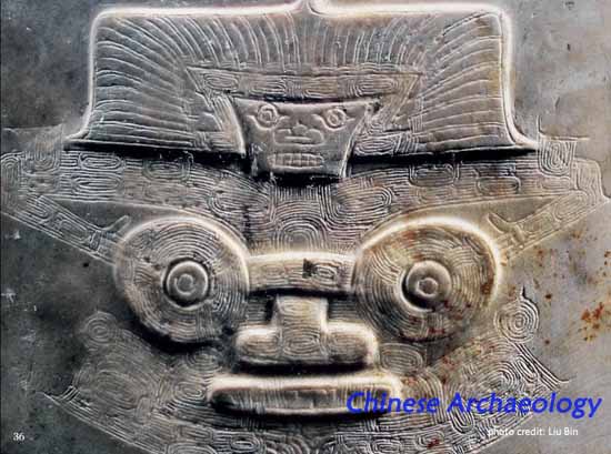
Archaeological excavations have provided evidence for intensive agriculture (primarily rice cultivation) and craft specialization (ceramic vessels, stone tools, jade objects, lacquer vessels) in the Liangzhu Culture. Fishing was another important method of obtaining food resources. Ceramic vessel assemblages often include ding tripods, dou stemmed dishes, shuangbi hu two-eared necked jars and ring-footed guan cylindrical jars. Some of the stone tools produced are ben adzes, yue axes, arrowheads, li triangular-shaped blade, dao knives and various farming tools. The main kinds of jade objects are cong tubes, bi disks, yue axes and huang half-disks, and some are in the shape of a guan cockscomb, sancha fork and zhui cone. The jade cong tube may have been an especially significant object used in ritual activities and the jade yue axe may be been a symbol of power. The shapes of jade objects are probably derived from “sacred insignia” and the dispersal of these shapes across multiple sites indicates that the Liangzhu Culture shared common sacred insignia. Social stratification is strongly apparent and, according to mortuary analysis, Liangzhu society can be divided into at least four tiers.
From the late-1980s to early-2000s, the Zhejiang Institute of Cultural Heritage and Archaeology conducted excavations in regions of Yuhang and Pingyao. Over one hundred Liangzhu sites have been discovered in an area of 50 km², among which is the Mojiaoshan palace site that is over 30 hectares in size, and to its north, between the center of the Liangzhu site complex and the mountain, are remains of a dam-like artificial feature measuring at about 5 km (north-south). These remains underscore the importance of the Liangzhu site complex in Liangzhu Culture.
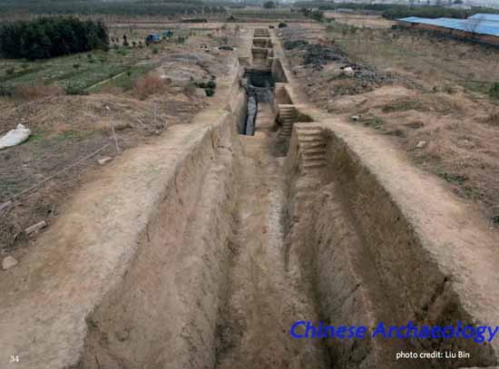
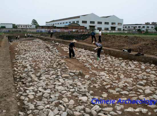
Over a two-year period in 2006 and 2007, the Zhejiang Institute of Cultural Heritage and Archaeology unveiled an ancient city (gucheng) with the Mojiaoshan site as its center. The city wall encloses an area of about 300 hectares, rectangular in shape, approximately 1900 m from north to south, 1700 m from east to west. The width of the rock base of the city wall averages at 40-60 m, with the widest part measuring at 100 m. The wall has a layer of rock at the base and the body of the wall is comprised of yellowish clay, the most well preserved section of the wall is 4 m above the current ground surface. On each of the north, east and south side of the wall are two city gates (shuichengmen). The west side remains unexcavated as it is buried beneath a village. The eastern gate in the north wall is 30 m wide, at the base are alluvial deposits and embedded within the wall are wooden plinths. More investigation is required to determine when the wall was constructed but the late Liangzhu date of the deposits on top of slopes of the wall indicates that the earliest possible time period for the usage and abandonment of the wall should not be later than late Liangzhu. The unearthing of this ancient city sheds new light on the process of social complexity of Liangzhu Culture.
Between 2009 and 2011, we surveyed an area of about 8 km2 outside the Liangzhu ancient city, searching for more information about ancient topography and settlement patterns. The long strips of elevated areas adjacent to the ancient city are Bianjiashan, Zhengcun, Lishan, Biandanshan and Heshangdi, together they form the basic configuration of the outlying areas. In 2010 and 2011, excavations east of the city at Meirendi and Lishan disclosed a habitation site situated on artificially elevated areas atop a kind of wetland, forming a housing type that is constructed above water. Biandanshan, excavated in 2012-2013, is also an artificially constructed habitation site. This layout consisting of long strips of elevated areas distributed within specific distances beyond the city wall appears to have been planned. Dated to late Liangzhu, these areas may have been intended to be external components of the ancient city.
Between 2009 and 2011, we excavated the Penggongxiang region located roughly 8 km north of the ancient city, uncovering the Ganggongling, Qiuwu, Shiqu and Laohuling sites, which may have together formed a coherent flood protection system with the Tangshan site that runs along the mountains north of the ancient city. The Tangshan site measures at 6 km in length, 50 km in width and 4 to 5 m in height. The Ganggongling section of the dam-like feature sits between two mountains and its construction is not unlike Mojiaoshan, with greenish soils at the bottom and pure yellowish clay on top. Grass-tempered clay (caoguoni) can be clearly seen in the bottom layer. The dates from the dendro-chronological calibration of the three plant fiber samples obtained from the grass-tempered clay at the Ganggongling site are between 4900-5000 BP.
In 2012-2013, we concentrated on excavating the ancient city site and revealed a complete river system within the city walls, with crisscrossing waterways, which likely served as a crucial mode of transportation at the time. Evidently, the Liangzhu harbor south of the ancient city and the channels of water around Huchitou were already in use five thousand years ago.
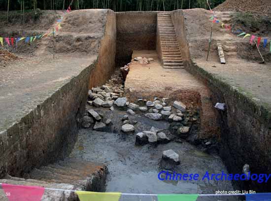
The palace sector is comprised of artificially elevated platforms occupies most of the city. The Mojiaoshan earth platform in the center is rectangular, 670 m from east to west, 450 m from north to south, measuring over 30 hectares in area and 14 m in height. The base of the platform is composed of greenish soils obtained from the wetlands and the layer above it is comprised of yellowish clay from the mountains. Sandy layers are found in the plaza at the center of the site, as well as very large postholes. There are three smaller platforms on top of the large Mojiaoshan platform, referred to as Damojiaoshan, Xiaomojiaoshan, and Wuguishan. In the northwest corner of the Mojiaoshan site is the Fanshan cemetery, which contains 11 burials and a wealth of jade objects. Having carefully investigated the eastern and western slopes of Mojiaoshan, as well as the southern and northern slopes of Damojiaoshan, we now have a better understanding of the boundaries, construction and dating of the two features. Excavations of the eastern slope of Mojiaoshan reveal that its periphery is built on a riverbank with grass-tempered clay at the base and, above it, are large quadrilateral slabs (fenkuaiban) pieced together. Abundant remains of carbonized rice grains amounting to a total weight of about 10,000 – 15,000 kg have been found on the eastern slope, suggesting that the granary at the Mojiaoshan palace complex may have caught fire, resulting in the concentration of carbonized grain remains in this area. Excavations of the Mojiaoshan western slope in early- to mid-2012 indicate that a river may have separated Mojiaoshan and Jiangjiashan. Later on that year, we excavated a late Liangzhu riverbed and alluvial banks. The lower terraces along the riverbank are composed of grass-tempered clay and traces of wooden mortise and tenon structures (sunmao jiegou) have been found. Excavations of the Damojiaoshan southern slope revealed a ditch, at the base of which is a layer of rectangular wooden planks.
In our surveys and excavations, we focused on determining the construction, distribution and dating of the Liangzhu ancient city. Scientific techniques and methods are employed in our research and analysis. We established a survey control network covering the entire Liangzhu site complex. Unmanned aerial vehicles and other technologies are used to obtain maps, orthophotographs and digital line graphs. In the outlying areas of the ancient city, Mojiaoshan, Ganggongling and other sites, we performed high accuracy magnetic measurements, high density electrical prospecting and radiometric surveys. Using GIS data, we built digital elevation models to aid our investigation of the layout inside and outside of the ancient city. Research on the rock bases of the city walls was conducted and samples of botanical remains were tested. Our knowledge of the natural environment around the ancient city has also been advanced. The many excavations and surveys conducted show that prevalent across the late Liangzhu stratigraphic layer of the site is a light tan silty clay characteristic of floodplain sediments. In recent years, at sites such as Linping Maoshan and Yujiashan, a similar kind of floodplain sedimentation has been found. These findings offer us valuable clues for identifying the reasons behind the decline and eventual abandonment of the Liangzhu ancient city.

The Liangzhu ancient city is the first city of the Liangzhu Culture excavated in the region of the Lower Yangtze River Delta, the largest of its kind in China during this time period. We have clarified the basic layout of the inside and outside of the city. The palace sector within the city walls and the flood protection system on the peripheries of the city are grand constructions, signifying a crucial moment in the development of social complexity five thousand years ago. The impactful legacy of Liangzhu Culture is seen in Longshan in Shandong, Taosi in Shanxi, Qijia in Ganqing and many other sites in northern Shaanxi, where cong tubes, bi disks and other jade objects reminiscent of Liangzhu Culture have been unearthed.
Biographical Sketch
Liu Bin obtained his BA (1985) in Archaeology at Jilin University. Since then, he has been working at the Zhejiang Institute of Cultural Heritage and Archaeology and is currently the deputy director of the institute and oversees the Liangzhu Archaeological Site. He has participated in the excavations of Fanshan and Yaoshan in Zhejiang, Zhongbaodao in Hubei and numerous other sites. He led the excavations of Heyedi, Shendunmiao, Huiguanshan, Nanhebang and other important Neolithic sites. Between 2006 and 2007, he directed the survey of the Liangzhu site complex, which resulted in the discovery of the Liangzhu ancient city. Since 2008, excavations of the ancient city have continued under his direction. Among his publications are Nanhebang: Excavation Report of a Songze Culture Site (Beijing: Wenwu, 2005), Complete Collection of Jades Excavated in China: Zhejiang (Beijing: Kexue, 2005) and The World of Spirits and Shamans: On Liangzhu Culture (Hangzhou: Zhejiang Photographic Press, 2007).