ARCHEOLOG-HOME / INDIana-UNIversitas
Contact


Lake Huron (USA):9,000-Year-Old Caribou Hunting Ground Reveals Ancient Hunting Techniques
University of Michigan
Source - http://phys.org/news/2014-04-prehistoric-caribou-beneath-lake-huron.html#ms

Diver and ROV collecting samples. Credit: University of Michigan
Underwater archaeologists have discovered evidence of prehistoric caribou hunts that provide unprecedented insight into the social and seasonal organization of early peoples in the Great Lakes region.
An article detailing the discovery of a 9,000-year-old caribou hunting drive lane under Lake Huron appears in today's issue of the Proceedings of the National Academy of Sciences.
"This site and its associated artifacts, along with environmental and simulation studies, suggest that Late Paleoindian/Early Archaic caribou hunters employed distinctly different seasonal approaches," said John O'Shea, the Emerson F. Greenman Professor of Anthropological Archaeology at the University of Michigan and lead author of the article.
"In autumn, small groups carried out the caribou hunts, and in spring, larger groups of hunters cooperated."
According to O'Shea, who is also Curator of U-M's Great Lakes Division of the Museum of Anthropological Archaeology, the site was discovered on the Alpena-Amberley Ridge, under 121 feet of water, about 35 miles southeast of Alpena, Mich., on what was once a dry land corridor connecting northeast Michigan to southern Ontario.
Drop45 Drive Lane. Credit: University of Michigan
The main feature, called Drop 45 Drive Lane, is the most complex hunting structure found to date beneath the Great Lakes. Constructed on level limestone bedrock, the stone lane is comprised of two parallel lines of stones leading toward a cul-de-sac formed by the natural cobble pavement. Three circular hunting blinds are built into the stone lines, with additional stone alignments that may have served as blinds and obstructions for corralling caribou.
Although autumn was the preferred hunting season for caribou, the orientation of Drop 45 shows that it would only have been effective if the animals were moving in a northwesterly direction, which they would have done during the spring migration from modern day Ontario.
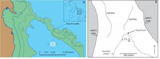
The Location of the Drop 45 Drive Lane. A. The American portion of the Alpena-Amberley Ridge during the later Lake Stanley low water phase (after ref. 14). Modern land is shown in brown, while areas of exposed dry land during Lake Stanley are green. Areas of water are presented in blue. The contour interval is 20 meters, with the modern lake shore represented as 176m amsl. Rectangular boxes locate the areas of active research. B. The topographic setting of the Drop 45 Drive Lane. Solid black lines represent 5 meter contours reported in meters amsl. The hatched area depicts areas that would have been under water at the time of use. This represents the Late Lake Stanley lake level, and reflects the last stable Lake Stanley elevation, roughly 40m amsl. The dotted lines represent low lines of stones channeling the movement of animals towards the middle of the landform. Inverted V symbols represent the location of V-shaped hunting blinds with their orientation reflected by the vertex of the ‘V’. The square symbol represents the location of a rectangular structure thought to represent a caching facility. Credit: University of Michigan
"It is noteworthy that V-shaped hunting blinds located upslope from Drop 45 are oriented to intercept animals moving to the southeast in the autumn," O'Shea said. "This concentration of differing types of hunting structures associated with alternative seasons of migration is consistent with caribou herd movement simulation data indicating that the area was a convergence point along different migration routes, where the landform tended to compress the animals in both the spring and autumn."
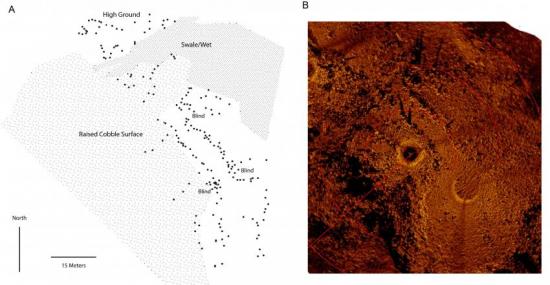
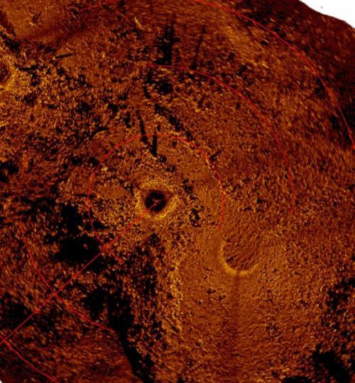
The Drop 45 Drive Lane. (A) A plan showing the major topographic and cultural features associated with the drive lane. Black dots represent the location of placed stones. The hunting blinds incorporated within the main drive lane feature are labeled. The raised cobble surface to the north and west of the drive lane varies from 1-2 meters higher than the bedrock on which the drive lane stones are located. This plan was produced as an overlay of the acoustic image. (B) An acoustic image of the drive lane produced via a mosaic of scanning sonar images. The scanning unit is the black circular area near the center of the image and the red circles surrounding have radii that increase by 15m. A trace of the second scanning sonar location is visible in the southeast of the image. Light colored objects are stones that produce a strong acoustic signature while dark areas are acoustic shadows. Credit: University of Michigan
The structures in and around Drop 45, and the chipped stone debris for repairing stone tools, provide unambiguous evidence for intentional human construction and use of the feature, O'Shea said. And they also provide important insight into the social and economic organization of the ancient hunters using this area.
"The larger size and multiple parts of the complex drive lanes would have necessitated a larger cooperating group of individuals involved in the hunt," he said. "The smaller V-shaped hunting blinds could be operated by very small family groups relying on the natural shape of the landform to channel caribou towards them."
More information: A 9,000-y-old caribou hunting structure beneath Lake Huron, PNAS, www.pnas.org/cgi/doi/10.1073/pnas.1404404111