ARCHEOLOG-HOME / INDIana-UNIversitas
Contact


Fishing for the first Americans
PART.2
Hinge-point hunt
Signs of early inhabitants are also starting to appear along the coast, particularly in spots where the swelling seas have not covered ancient shorelines since the end of the last glacial period. The western coast of Canada, for example, was pressed down by the Pleistocene ice and has been rebounding upwards since the glaciers melted. In some spots — hinge points — that post-glaciation rebound almost exactly cancels out the rising sea level2. One of those hinge points is Calvert Island, where a 13,200-year-old footprint was found late last year and another was discovered this summer. Daryl Fedje and Duncan McLaren, both archaeologists at the University of Victoria in British Columbia, plan to continue working the site to look for signs of the earliest Americans
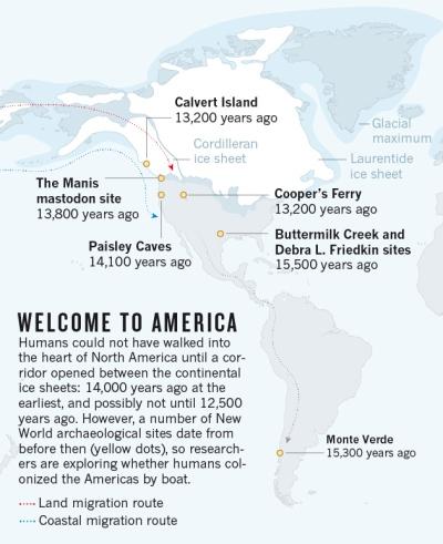 The Hakai Institute on Calvert Island, founded by Canadian entrepreneur Eric Petersen, is supporting that work. “As a fourth-generation British Columbian,” Peterson says, “I am intensely interested in the rich history of humans on our coastline, which we now realize goes way, way back. How far back? Thirteen thousand years? Fifteen thousand years? That's what we want to find out.”
Mackie thinks that Calvert Island and similar hinge points will produce results much faster than underwater work, which is technically challenging and expensive. “You might as well just stand on your boat and burn $100 bills,” he says.
But despite the enormous cost and technical challenges, he and others agree that underwater locations may hold tremendous potential and that the time has finally come for archaeologists of American prehistory to explore the Pacific Ocean. There have been a few projects over the years. In the late 1990s, Mackie and Fedje did some sea-floor mapping around Haida Gwaii, an island off the British Columbia coast3. They took samples of sea-floor sediment and hauled up a barnacle-encrusted flake tool that they suggest dates from 10,000 years ago, when the sea floor on which it was found was dry land. More recently, the duo used an autonomous underwater vehicle to explore and found what they suggest could be a fishing weir — a trap made from rocks — that dates back 13,800 years.
Archaeologist James Dixon of the University of New Mexico in Albuquerque has done marine surveys of the now-submerged land that once connected Asia and North America. And Jon Erlandson, an archaeologist at the University of Oregon in Eugene, has worked for years on the Channel Islands off Southern California, piecing together evidence for his theory that people followed a 'kelp highway' down the coast. This route would have offered abundant food — fish, shellfish and marine mammals — supported by the kelp forest ecosystems.
But the offshore studies so far have been limited, and most of the discoveries have not been reliably dated. “There's very few of us, and we are spread over vast, vast areas,” says Dixon. There has been a hesitation to join — or fund — the chancy and expensive underwater search. “You can go out there and be totally skunked by the weather,” he says. “It is a tough thing.”
That has led many researchers to discount the coastal hypothesis in the past, notes Mackie. “People thought 'well, all the information is deep underwater and we'll never find it',” he says. And so far, nothing older than the Clovis era has been found along the Pacific Coast — either on the sea floor or on land.
Spark of interest
What snapped the field out of its funk was not a charismatic leader or a spectacular find — it was federal bureaucracy.
The US Bureau of Ocean Energy Management (BOEM) was formed in 2010 to regulate energy development on the continental shelf. The bureau is bound by the National Historic Preservation Act, which requires it to make sure that valuable archaeological sites will not be destroyed by any development that requires a federal permit. As interest in offshore renewable-energy projects has increased in recent years, BOEM has scrambled to improve methods for identifying prehistoric sites.
In 2011, it commissioned a sweeping study of possible archaeological sites on the Pacific outer continental shelf. Davis and a colleague at Oregon State, archaeologist Alex Nyers, worked on the report, using existing ocean-depth data and estimates of sea-level rise to decipher where previous shorelines would have been4. They then modelled where prehistoric sites might be clustered: presumably on gentle, south-facing (and thus warmer) slopes and near lakes, rivers, bays and islands, all now submerged.