ARCHEOLOG-HOME / INDIana-UNIversitas
Contact


El Mirador (Guatemala): Maya Superhighway Discovered
El Mirador, a late Mayan preclassic city located in the heart of the Petén jungle, the Guatemalan department bordering Mexico, is the cradle of this empire and has a great variety of flora and fauna, as well as "The world's first network of super highways".
Patricia Legs
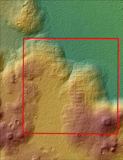
 Photograph courtesy of the Cuenca Mirador Archaeological Project, taken through a high-precision radar in El Mirador, a late May-early preclassic city located in the heart of the jungle of Petén, the Guatemalan department that borders Mexico. EFE / Archaeological Project Cuenca Viewpoint
This is one of the conclusions presented today in Guatemala City after a high-tech research carried out in this area, within the framework of the "Cuenca Mira Pain Archaeological Project ", through a kind of high-precision radar called LIDAR.
The director of this program, American scientist Richard Hansen, a great connoisseur of this culture, explained that this study, unique in Mesoamerica, has revealed that Guatemala "has the privilege of being the cradle of Mayan civilization", with the Higher pyramids and a "single" road network.
Scan the terrain with laser
The LIDAR mapping, which scans the terrain with a laser that can penetrate the canopy of vegetation at a rate of 560,000 dots per second, has allowed to identify unique archaeological features in 2D and 3D images that constitute "important findings" for the study of the Mayan culture.
In this first phase, in which they have analyzed more than 700 square kilometers, acropolis, waterfalls, pyramids, terraces, canals, dykes, walls and a network of roads of more than 240 kilometers in length - by 40 wide and About 2 or 6 high-that allows to conclude that the Mirador was a "closed political system".
"The first state of all the Americas," Hansen proudly proclaimed to Acan-Efe, adding that in his day he would be the largest in the world, both in size and population. It is estimated that at least 1 million people inhabited the area before its collapse in 150 BC. This network of roads, at least about 17, were used for freight transport.
This research has allowed us to reach this conclusion, in addition to believing that the Maya had here a "system of pens" that may be the first production of meat at an industrial level, although analyzes to reaffirm this hypothesis are still in process .
These discoveries, adds the topographer Josephin Thompson, have allowed advancing in two years which would take about 40, and helps to be more precise to understand the settlements and cities of this culture.
 Photograph of El Mirador, a late Mayan preclassic city located in the heart of the Petén jungle. EFE / Archaeological Project Cuenca Viewpoint
Next year, researchers will continue with the project and ask governments to develop a tourism route that respects the environment, "without creating roads" and provoking "the minimum impact", something similar, apposes Thompson to Efe, to those who have done In Peru with Machu Pichu, although this can cost up to 100 million dollars.
At present, about 3,000 tourists arrive in El Mirador on foot or on a mule, but it is necessary to provide security and attention to this cultural enclave to preserve it "intact" and thus "to be able to understand the evolution of society".
To preserve this area, the American archaeologist does not hesitate to ask the governments of Guatemala and Mexico, as far as El Mirador extends, to protect the area and promote sustainable tourism: "El Mirador is a jewel. We are just the messengers, you are the owners. Keep it. "
El Mirador - known as the Kan Kingdom - has an area of 2,158 square kilometers in the middle of the Maya Biosphere Reserve and is one of the environmental and cultural lungs of the Americas. EFE