ARCHEOLOG-HOME / INDIana-UNIversitas
Contact


Cold War reconnaissance photos triple the number of known archaeology sites across the Middle East
Dan Vergano
Source - http://news.nationalgeographic.com/news/2014/04/140425-corona-spy-satellite-archaeology-science/
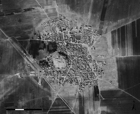
This 1961 satellite photo shows Tell Rifaat in northwest Syria; it's now completely surrounded by a modern town.PHOTOGRAPH COURTESY INTERNET ARCHAEOLOGY/ JESSE CASANA, JACKSON COTHREN AND TUNA KALAYCI
A study of Cold War spy-satellite photos has tripled the number of known archaeological sites across the Middle East, revealing thousands of ancient cities, roads, canals, and other ruins.
In recent decades archaeologists have often used declassified satellite images to spot archaeological sites in Iraq, Turkey, and Syria.
But the new Corona Atlas of the Middle East, unveiled Thursday at the Society for American Archaeology's annual meeting, moves spy-satellite science to a new level. Surveying land from Egypt to Iran—and encompassing the Fertile Crescent, the renowned cradle of civilization and location of some of humanity's earliest cities—the atlas reveals numerous sites that had been lost to history.
"Some of these sites are gigantic, and they were completely unknown," says atlas-team archaeologist Jesse Casana of the University of Arkansas, who presented the results. "We can see all kinds of things—ancient roads and canals. The images provide a very comprehensive picture."
The team had started with a list of roughly 4,500 known archaeological sites across the Middle East, says Casana. The spy-satellite images revealed another 10,000 that had previously been unknown.
The largest sites, in Syria and Turkey, are most likely Bronze Age cities, he says, and include ruined walls and citadels. Two of them cover more than 123 acres (50 hectares).

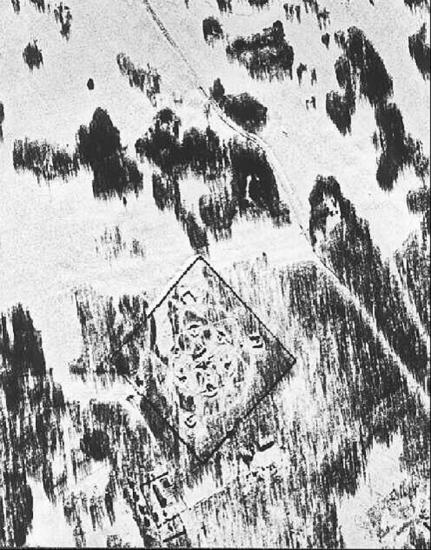
Signs of ancient habitation are visible in this satellite image of Tell Hamoukar in eastern Syria. PHOTOGRAPH COURTESY INTERNET ARCHAEOLOGY/ JESSE CASANA, JACKSON COTHREN AND TUNA KALAYCI
But, says Casana, "it's not just new places to excavate. We have a real way with all these sites to look across the whole Middle East and see how it was connected."
The new Middle East atlas reflects both the opportunities and challenges facing archaeologists, who must handle ever larger amounts of data from excavation sites and entire regions, says information-science scholar Eric Kansa of the Alexandria Archive Institute in San Francisco, who spoke at the meeting. "This is big data," Kansa says. "We have the opportunity to really blow up the scale of our efforts in archaeology."
Cold Warrior
The end of the Cold War led to the public release of Corona spy-satelliteimages by U.S. defense officials almost two decades ago. The spy satellite made images from 1960 to 1972, and the atlas samples only some of the 188,000 images taken from 1967 to 1972 by the last generation of the satellites. The images of the Earth's surface, intended to expose Soviet missile bases and military camps, had a resolution of two meters (6.6 feet).
A missile launch site near Chelyabinsk in the USSR is outlined in this 1969 image. PHOTOGRAPH COURTESY NATIONAL RECONAISSANCE OFFICE
Current imaging satellites, such as the privately owned DigitalGlobe based in Longmont, Colorado, return better resolution images, but "they can't go back in time," says Casana.
The Corona images, he explains, were made before cities such as Mosul in Iraq and Amman in Jordan overran the many archaeological sites near them. Dams have also flooded river valleys, covering many other archaeological sites. As cities grew, the industrial farming and irrigation that supported them grew too, obscuring roads and sites clearly visible in the spy-satellite images.
"Even with much better resolution, we can't see a site that someone has covered up with a building," Casana says.
Information Warfare
"This project is just incredible," says Syro-Palestinian archaeologist David Schloen of the University of Chicago. "It's amazing what their atlas can do."
The mapping team, for example, set up their site to allow you to look at the 1960s images of a given location side by side with views of it today.
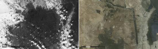
The 1960s image at left captures an area of southern Iraq's marshes, many of which have since been drained. The photo at right is of the same location in the early 2000s. PHOTOGRAPH COURTESY INTERNET ARCHAEOLOGY/ JESSE CASANA, JACKSON COTHREN AND TUNA KALAYCI
Corona satellites photographed the Earth in swaths 120 miles (193 kilometers) long by 10 miles (16 kilometers) wide. Film strips were delivered from space inside parachute-equipped buckets, and the film's stretched and distorted views of the Earth required special optics to sort out. The existence of the photographs was officially kept secret until 1992.
Much of the atlas team's work has involved tying landmarks in the Corona images, purchased from the U.S. Geological Survey, to mapped landmarks in modern-day images. The landmarks also helped computers remove distortions in the original spy-satellite images.
"We don't want to stop here," Casana says. Many of the Corona images cover other areas of great interest to archaeologists, including Africa and China.
"Corona is amazing," he says. "We really have coverage from almost everywhere."