ARCHEOLOG-HOME / INDIana-UNIversitas
Contact


Chincha Valley (Pérou): Rock Art Pointed to Festival Sites in 300 B.C.
Bob Yirka report
Source - http://phys.org/news/2014-05-field-geoglyphs-ancient-peru-fairs.html
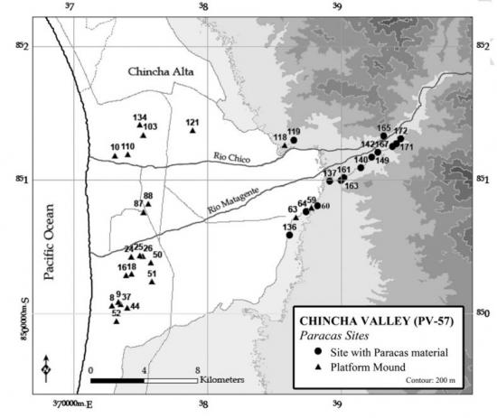
Distribution of archaeological sites linked to Paracas period settlement in Chincha, Peru. Redrawn from Canziani. Credit: (c) Charles Stanish, PNAS, 2014. doi: 10.1073/pnas.1406501111
A team of researchers with the University of California, led by Charles Stanish has concluded that lines of rock piles (geoglyphs) in the Chincha valley in southern Peru were constructed to serve as guidelines directing travelers to trade fairs on the coast. In their paper published in Proceedings of the National Academy of Sciences, the team also notes that U shaped mounds were almost certainly meant to celebrate the winter solstice.
Famous lines scratched in the desert floor in southern Peru have been attributed to the Nazca people who lived in the Chincha Valley between 400 and 650 AD—seen from above they depict animals and other objects. In this new effort, the research team was studying a similar culture that existed in the same valley (though farther north) at an earlier time. The Paracas culture which is believed to have existed from 800 to 100 BCE, are the people believed to be responsible for creating long lined geoglyphs in the desert valley, some of which stretch for nearly two miles. Stanish et al believe that the lines were created as a form of combination map and advertisement. People coming down from the mountains would have been able to see them—if they traveled towards the coast following the same angle as a given rock line, they would wind up at Paracas trade fairs.
The research team came to this conclusion by creating a map that showed all 71 known geoglyphs in a 15 square mile area. They also added mounds to the map, which are now Paracas excavation sites near the ocean, along with other known settlement sites. The result, the team reports, was very clear—many of the geoglyphs formed a partial starburst of sorts with mounds at their center. They made it possible for travelers coming from any easterly direction to find the trade centers—all they had to do was follow the rock lines.
The researchers found that other geoglyphs likely were used to lead people to pairs of U shaped mounds, which the researchers believe, were used as a means of celebrating the June (winter) solstice. The sun sets between them on that date. Leading people from other areas to trade fairs, the researchers suggest, could possibly have become competitive as different groups of Paracas people living in different settlements strove to lead traders to their fair, resulting in longer and longer geoglyphs.
More information: A 2,300-year-old architectural and astronomical complex in the Chincha Valley, Peru, Charles Stanish, PNAS, 2014. DOI: 10.1073/pnas.1406501111
Abstract
Recent archaeological research on the south coast of Peru discovered a Late Paracas (ca. 400–100 BCE) mound and geoglyph complex in the middle Chincha Valley. This complex consists of linear geoglyphs, circular rock features, ceremonial mounds, and settlements spread over a 40-km2 area. A striking feature of this culturally modified landscape is that the geoglyph lines converge on mounds and habitation sites to form discrete clusters. Likewise, these clusters contain a number of paired line segments and at least two U-shaped structures that marked the setting sun of the June solstice in antiquity. Excavations in three mounds confirm that they were built in Late Paracas times. The Chincha complex therefore predates the better-known Nasca lines to the south by several centuries and provides insight into the development and use of geoglyphs and platform mounds in Paracas society. The data presented here indicate that Paracas peoples engineered a carefully structured, ritualized landscape to demarcate areas and times for key ritual and social activities.
PHOTOS :
Paracas geoglyphs were aligned with the sunset on the winter solstice. PHOTOGRAPH BY C. STANISH

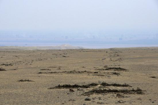
Marred by tire tracks, geoglyphs line the Andean highlands. PHOTOGRAPH BY C. STANISH
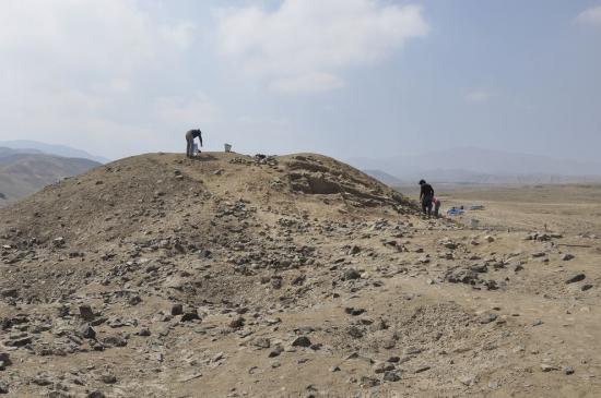
The Cerro Gentil pyramid, shown here, aligns with the solstice sun. PHOTOGRAPH BY K. PEREZ
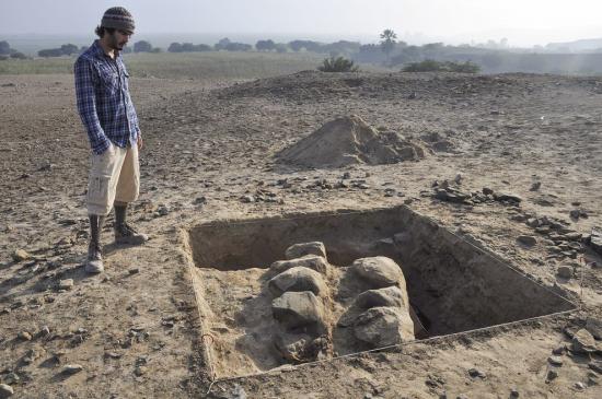
Ceremonial mounds, here under excavation, were aligned with the geoglyphs. PHOTOGRAPH BY C. STANISH