ARCHEOLOG-HOME / INDIana-UNIversitas
Contact


Carwynnen Quoit (G-B): a burial chamber in Neolithic Cornwall
Ben Miller
Jacky Nowakowski, the Lead Archaeologist with the Cornwall Archaeological Unit, on the amazing restoration of the Carwynnen Quoit megalith
"When the three granite uprights and the massive capstone collapsed in the 1960s earth tremor, they created a heap of stones which protected the ground beneath.
During the ensuing 50 years of land clearance, more large stones were heaped up onto the pile. These continued to ensure that the original area of the monument chamber was protected from later damage by ploughing.
The floor of the monument, an intact stone pavement, is made up of a narrow strip of compacted small stones which formed a hard-standing surface arranged in a doughnut-like circuit.
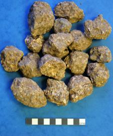
Granite balls from Quadrant 3
This embraced the central part, made up of slightly larger stones pressed firmly into the soil beneath.
More than 2,000 finds were made in our 2012 test pits and Big Dig trench, covering a wide variety of objects dating to all ages.
The main discovery was the partial survival of a remarkable stone pavement on the footprint of the original Neolithic monument, made up of small stones mainly of granite with some quartz pieces covering an area of approximately 5.5m² under topsoil.
At the rear of the monument, between Stones 3 and 4, the remnants of a stone kerb made up of small stones set on edge was found. This contained a stone floor at the back of the open chamber.
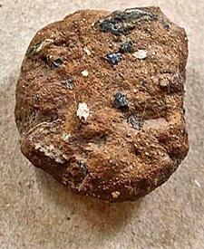
More than 20 fragments of Early and later Neolithic pottery were found, made of gabbroic clays – some with quartz added. This clay comes from the Lizard, 30km southwest, and its discovery here at Carwynnen demonstrates exchange networks between small communities throughout this period.
More than 100 pieces of flint were found. Many were burnt and many were broken and snapped fragments of tools.
The 5,000-year-old burial chamber is known as The Devil's Frying Pan
Highly distinctive worked stone objects spanning 3,000 years were also found: a stone hammer cobble; a small rounded greenstone hammer stone; a water-worn cobble; the fragment of a greenstone whetstone and the fragment of a saddle quern.
Of particular interest was a greenstone pestle which was found embedded in the pavement – possibly a votive offering.
The greenstone is likely to come from within five kilometres of Camborne. Some of the most distinctive finds were small, rounded granite balls – many the size of golf balls.
These were found in all contexts during the Big Dig and many were embedded into the pavement. On average these are 400mm in diameter and weigh 100g.
Geologist Colin Bristow suggested that because of their consistent size they could have been deliberately collected and brought to the quoit, possibly left behind as tokens by visitors throughout prehistory.
This may be like people today leaving personal trinkets at the resting places of departed loved ones, or even perhaps the “prayer stones” left by mourners at key places of remembrance.
All this evidence points to the primary commemorative role of Carwynnen Quoit 5,000-6,000 years ago, and its major purpose as a community monument: conceived, built, maintained and remembered by and for the prehistoric communities who once lived in the immediate landscape.
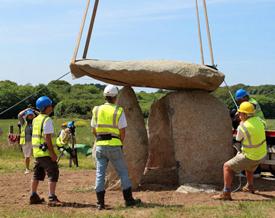
Two months later, the Big Dig commenced. A large excavation trench, surrounding the location of the collapsed quoit, was opened.
The three-week dig started on 17th September 2012, covering a total area of 0.03 hectares. A week earlier the stones had been moved to one side by crane, watched by a large crowd.
Within this area were many of the back-filled evaluation test pits dug earlier that summer, which had potential for the survival of buried archaeological layers.
This core area (11m long and 9m wide) was divided into four quadrants separated by 0.4m wide baulk sections which radiated out from the area where the stones once lay.
A notched point-awl© Historic Environment
The baulks provided cross-sections of the profiles through topsoil, subsoil and layers down to the undisturbed ground. It is in these standing sections that the time-depth story of the site (the stratigraphy) is captured and can be read like the pages of a book.
That autumn the socket holes for the three uprights were identified and two were fully investigated. One (for Stone 2) had been heavily disturbed, its sides ragged and the fills loose with animal burrowing.
The sides of the third socket hole, for Stone 3, at the back of the monument, had stone lining in situ. Fills at the base of this massive hole (1.5m in diameter and 0.70m deep) were “clean” and produced grain and young wood charcoal which were radio-carbon dated in early 2013.
The results gave a date in the “modern period” and the material must have entered the socket hole during the 19th century restoration. The stone pavement, alongside many prehistoric pot sherds and flints, gave us a clear insight into the design of the original monument as well as an indication of how enduring its presence was in the landscape.
Finds from the Early Neolithic to Iron Ages were recorded. At the end of the Big Dig the site was re-buried, protected by a geotextile so that it could be re-opened for archaeological excavation.
This gave the team a chance to review the discoveries and develop a plan for further fieldwork.
Six months later, some of the volunteers met to measure the stones. The previous September, the pile had been dismembered by crane and set out into two groups close to the area where they once lay.
One pile included the stones which made up the monument, the other was made up of large stones which had been dumped here after the collapse in 1967.
During the day the team studied the major quoit stones, the capstone and the 3 uprights. This was the first time the stones were available for detailed study since the last recorded measured survey of the monument, which had been carried out by antiquarians WC Borlase and G Lukis when it was still upstanding in 1879.
The site was also surveyed in 1984. A measured survey of the stones was carried out in 2009, after the purchase by Sustrust, but at that time only parts of each stone were visible for measurement.
In July 2012, 20 one-metre trial holes were dug under the supervision of the Cornwall Archaeological Unit and Cornwall Council, providing outline information about below ground preservation and contribute to a more detailed field investigation.
The results would guide the future reinstatement of the stones and the final restoration of the monument by establishing the key areas of archaeological potential as well as the edges of the monument.
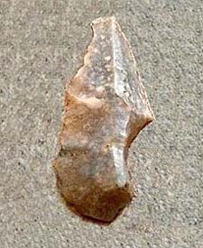
An oblique arrowhead© Historic Environment