ARCHEOLOG-HOME / INDIana-UNIversitas
Contact


Caney Fork Creek Valley (USA) - Judaculla Rock portrays map of ancient towns in the North Carolina Mountains
Judaculla Rock portrays map of ancient towns in the North Carolina Mountains
Richard Thornton
In the Caney Fork Creek Valley near Western North Carolina University and the city of Cullowhee are three boulders displaying petroglyphs. The largest and most intensely inscribed boulder is 16 feet long and 11 feet wide. It is the largest set of petroglyphs in North Carolina. The rock was named for a giant named Judaculla in Cherokee Indian folklore. Like many of the petroglyph boulders across the state line in Georgia, the Judaculla boulders are soapstone.
Prior to having knowledge of pottery, Native Americans made cooking bowls out of soap stone. Even after ceramics became common place, certain decorative and utilitarian objects such as grindstones, pipes and fishing sinkers, were still made out of soapstone. The oldest Native American pottery is found in eastern Georgia (2500 BC.) The technology apparently spread to other parts of North America and Mexico from there.
The designs on the rocks were made by a variety of techniques, including incising, pecking and smoothing. During the latter half of the 20th century, acid rain created by the many coaled fired power plants in the Tennessee Valley, have severely eroded the boulder. Current analysis of the petroglyphs must be based on drawings from the 1930s, before the power plants were built.
The petroglyphs in Cherokee folklore and North Carolina archaeology
Smithsonian Institute ethnologist, James Mooney, wrote in the 1880s that the Cherokees like to camp around the rocks, when hunting. It is also documented that the Cherokees held ceremonial assemblies in a meadow near the rocks.
In Cherokee folklore, the petroglyphs were created by a giant named Tsul-ka-luor Tsu’ Kalu which means the Great Slant-eyed Giant. In one version of their folklore the glyphs were hunting laws. In another the glyphs were scratching of the giant’s toenails.
North Carolina scholars, who have studied the Judaculla Rock, currently believe that the inscriptions were made before the arrival of the Cherokees; probably dating from 3000 to 1000 BC. In North Carolina official archaeological site files, the Judaculla Rock is classified as an Archaic or Early Woodland site.
The North Carolina Rock Art Survey organized a Judaculla Advisory Committee composed of property owner, members of the Eastern Band of the Cherokee Tribal Historic Preservation Office, Tribal Elders, the Office of State Archaeology, professors from nearby Western Carolina University and members of the surrounding community.
It is a territorial map with Maya-Muskogean symbols of authority
It is quite likely that for thousands of years various native peoples came to the Judaculla rocks to carve bowls, pipes, metates, etc. The smaller petroglyphs on the rock may be “graffiti” left by visitors to the rock or special symbols carved by Native American holy men. These symbols include the abstract humans, animals and possibly the line-bar-dot glyphs.
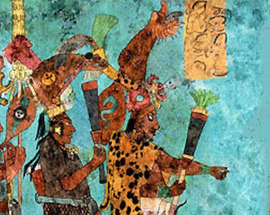
The sceptors and maces portrayed on the Judaculla Rock developed in Muskogean provinces of the Southeast as copper and wood replicas of the sceptors and weapons carried by Maya nobles in Mesoamerica. Credit: Museo Nacional de Antropologia
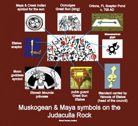
Many of the symbols on the rock could either be ancestral Creek or Chontal Maya since the basic symbols used by both ethnic groups were very similar. Credit: Richard Thornton
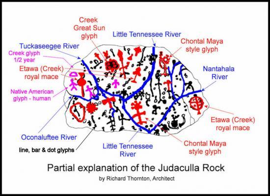
The locations of the rivers are remarkably similar to accurate maps today. Credit: Richard Thornton
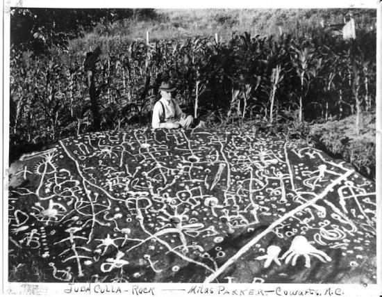
Around 1930 the petroglyphs were marked with chalk so they could be photographed. Acid rains have now eroded many of the images. Credit: Courtesy of NC Museum of History