ARCHEOLOG-HOME / INDIana-UNIversitas
Contact


Cahokia (USA): Missing Link? Mississippi Floods, and a Great City Disappears
Becky Oskin
Source - http://www.livescience.com/45102-cahokia-decline-mississippi-flood.html
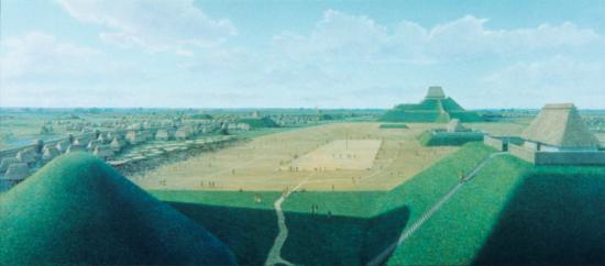
The pre-Columbian settlement at Cahokia was the largest city in North America north of Mexico, with as many as 20,000 people living there at its peak. Credit: Painting by Lloyd K. Townsend. Courtesy of the Cahokia Mounds State Historic Site, Illinois.
The mysterious abandonment of one of North America's first big cities may be linked to a massive Mississippi River flood 800 years ago, a new study finds.
In the bottom of an oxbow lake next to Cahokia, Ill., which was the most powerful and populous city north of Mexico in A.D. 1200, lie the buried remains of a flood that likely destroyed the crops and houses of more than 15,000 people. Researchers investigating pollen records of Cahokia's farming and deforestation discovered distinctive evidence of the flood: a silty layer 7.5 inches (19 centimeters) thick. The silt is dated to A.D. 1200, plus or minus 80 years, said Samuel Munoz, lead study author and a geographer at the University of Wisconsin-Madison.
The city wasn't completely abandoned until A.D. 1350, but the catastrophic flood could have shaken the confidence of the town, sited near modern-day St. Louis, Munoz said.
"I think the relationships between flooding and the decision to abandon the settlement are pretty complicated, but it's surprising and exciting to discover this flood happened right in the middle of a key turning point in Cahokia's history," Munoz said.
At its height, Cahokia sprawled over an area of about 6 square miles (16 square kilometers). Similar to modern-day New York City, Cahokia was an artistic and cultural center, where people brought in raw materials from across North America, and residents transformed them into exquisite goods.
Vast agricultural fields — where farmers grew crops such as corn, squash, sunflower, little barley and lambs quarters — surrounded the city. More than 200 earthen mounds rose from the city, many of which still loom over the landscape today.
Several years ago, Munoz set out to determine how Cahokia's residents shaped the local landscape; for instance, Munoz wanted to find out how much land was prairie and how much was forest, and how farming affected the region.
Cahokia's location near the confluence of major rivers made it a popular waypoint for some 2,000 years, according to Munoz's study, published April 10 in the journal Geology.
"There's not much that's natural about this place," Munoz told Live Science. "It's a great spot on the Mississippi, and it's really been affected by people for 2,000 years."
Pollen grains buried in nearby Horseshoe Lake show farming at Cahokia intensified starting about A.D. 450, accompanied by rapid deforestation. Corn cultivation peaked between A.D. 900 and 1200, during the height of the Cahokia culture, and then stopped around A.D. 1350. Farming and deforestation picked up again in the 1800s, with the arrival of Europeans.
Many theories have been offered for the city's abandonment, such as climate change and political battles, but researchers disagree on the ultimate cause.
No one knows where the Cahokia people went, but Mississippian cultural traditions continued in the Southeast for several centuries, Munoz said.