ARCHEOLOG-HOME / INDIana-UNIversitas
Contact


Boyne Valley (Irlande): First passage-tomb discovered for two centuries using new archaeological techniques
The first passage-tomb to be discovered in the Boyne Valley in 200 years has been identified by archaeologists using sophisticated imaging techniques.
Source - http://blog.mythicalireland.com/2013/08/first-passage-tomb-discovered-in-boyne_7705.html
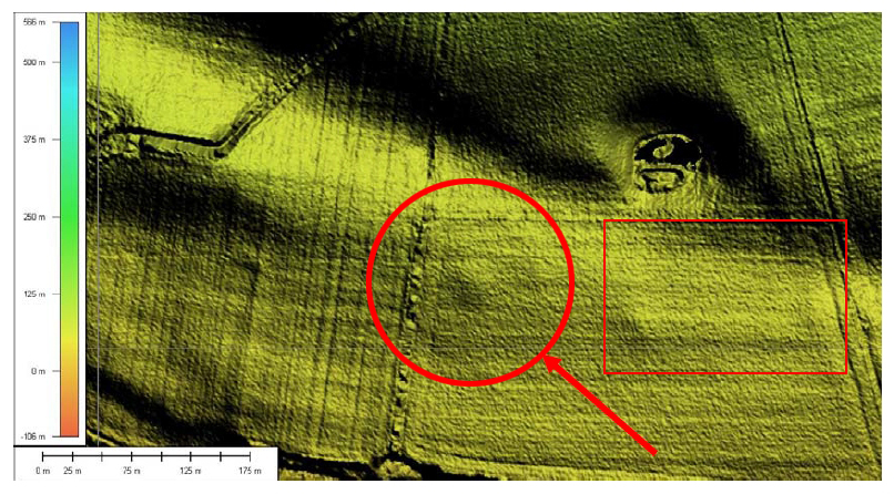
The newly discovered mound, with circular enclosure, shown on a colour LiDAR image. Reference: Boyne Valley Landscapes Project. Data: Meath County Council/Discovery Programme
Archaeological imaging and geophysics specialist Kevin Barton spoke about the discovery, made originally in 2010, at a recent Heritage Week presentation at the JFK Arboretum in County Wexford. He was giving a talk about possible new monuments discovered in LiDAR (Light Detection And Ranging) imaging of the Great Island area of Wexford.
The “new” passage-tomb, on the floodplain of the Boyne southwest of Newgrange, had showed up as a “blip” on LiDAR imagery of the valley, Mr. Barton said. Because of its situation in proximity to the Boyne monuments, it was considered that the feature warranted further investigation.
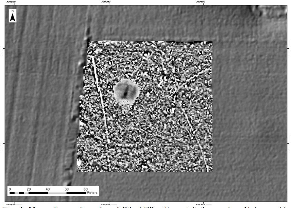
The newly discovered monument shown in gradiometry with resistance overlay. The dark linear feature running from SSW-NNE is believed to be a passage. The small dark circular area is the mound. The outer enclosure is also faintly visible. © Davis et al
The site was given the designation “LP2” by investigating archaeologists. In the LiDAR image it appeared there was a central mound with a circular outer enclosure feature. The enclosure was “faint but identifiable” in the image.
Further work, in the form of ground-probing techniques called Magnetic Gradiometry and Resistivity was carried out, and revealed what appeared to be a weakly defined outer enclosure in addition to a distinct passage/chamber arrangement of the passage-tomb aligned towards the north-northeast.
Archaeologists became excited about the central mound, which they said “appears to show a clear passage and chamber arrangement with splayed terminals at the NNE. The central mound is clearly identifiable and measures c. 30m in diameter. This strongly suggests that the feature represents a hitherto unknown passage tomb.”
Kevin Barton told the audience at his Co. Wexford talk that he believed it was the first passage-tomb to be discovered in the Brú na Bóinne complex in over 200 years. What makes the discovery very special is the fact that no archaeological digging took place to find it. It was discovered purely through LiDAR imaging and ground-probing techniques.
The area where the passage-tomb is located is close to the Boyne, straddling a modern hedgerow. The land has been under tillage and pasture at various times, and has probably been considerably ploughed over the years.
Commenting on the discovery, Anthony Murphy, author of Newgrange: Monument to Immortality said that it was just one of a number of exciting new features identified over the past few years in the Boyne Valley.
“This is incredible work by archaeologists using an array of new techniques. They have found a passage-tomb that has been hidden in the landscape for millennia, and they have found it without putting a single trowel into the ground.”

This is a wider LiDAR image of the Boyne Valley. The location of the new monument is shown by the red circle. Map: Boyne Valley Landscapes Project. Source of data: Meath County Council/Discovery Project.
“I am particularly excited by the suggestion that the passage of this newly-discovered monument may point towards the north-northwest. If that’s the case, there are two possibilities which I’d like to see examined. One is that the passage points back up the slopes of the valley towards Newgrange. The second is that, because it points to the north-northwest, it cannot be aligned on a sunrise or moonrise, and one could propose a stellar alignment," Mr. Murphy said.
“It’s obviously far too early to say whether that’s the case. But I would definitely be interested in finding out whether there might have been an alignment to Deneb, the bright star of Cygnus, the swan constellation. The Brú na Bóinne area is linked with significant swan mythology. Indeed the owner of Newgrange, Aonghus Óg, was said to have taken the form of a swan. And the fields where this newly discovered mound is located have been the wintering ground for the whooper swans, which have been coming to Newgrange in large numbers for many decades, and possibly since the time Newgrange was built.”
But this newly-discovered monument might never be excavated. Kevin Barton said in his talk that archaeological digging is not only invasive, but destructive.
The new electronic arsenal employed by archaeologists is, however, providing the means to look under the soil without ever having to dig. And Mr. Barton said the equipment and the analysis of data were improving all the time. The new breakthrough is a testament to the exciting prospects of discovery in future of monuments that are currently hidden from view in the landscape.
Some of these new techniques have been employed at the Hill of Slane, where a mound, also surrounded by a circular enclosure, is thought by some to have originally been a passage-tomb, possibly as old as Newgrange, which was later re-fashioned by the Normans into a defensive motte.
Some new techniques will also be employed to examine the possibility that Millmount, in Drogheda, is also an ancient passage-tomb which was re-used by the Normans and later by the British who fortified the mound with a martello tower on top.
Acknowledgements: Steve Davis, Conor Brady, Kevin Barton and Will Megarry (archaeology); funded by the Heritage Council (INSTAR); Meath County Council (LiDAR imagery); the archaeologists are very grateful to the Redhouse family for access to the land.
Boyne Valley Landscapes Project: Steve Davis, William Megarry. Conor Brady, Helen Lewis, Thomas Cummins, Loreto Guinan, Jonathan Turner, Colman Gallagher, Tony Brown and Robert Meehan.
See Boyne Valley Landscapes Project Phase III Summary Report and Phase III Final Report.