ARCHEOLOG-HOME / INDIana-UNIversitas
Contact


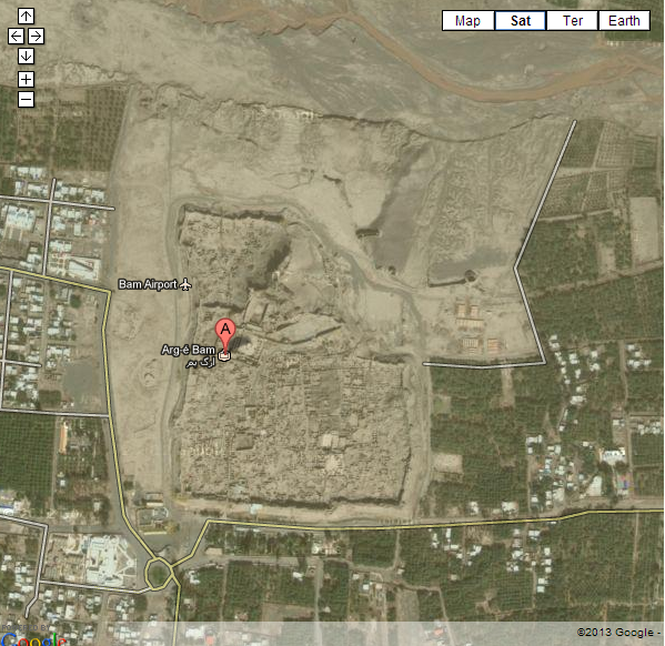
Bam (Iran): New archeological discoveries in Afraz (Bam fault)
|
Source: Tavoos (translated by Arash Aliasghari) http://www.payvand.com/news/13/jan/1054.html On the eve of the ninth anniversary of Bam earthquake, an expert in the field of world heritage, Dr. Shahriar Adle reported on new discoveries of ancient altars in Afraz (Bam Fault) and the identification of the first layers of Bam citadel (Arg-e-Bam)'s ancient defensive wall.
Dr. Adle told ISNA: During recent years and since the inscription of Arg-e-Bam on the list of world cultural heritage, many measures have been taken in order to preserve this historical complex. This year, in collaboration with Arg World Heritage Base, several archaeological teams, have done different surveys. Meanwhile, the archaeologists of Arg Base continued their own excavations and they have achieved satisfactory results. An amateur archaeologist in Bam, succeeded to discover for the first time, a number of petroglyphs related to at least 3 different historical eras which depict hunting scenes and portray animals such as wild goat, ram, ... While looking for a suitable itinerary for Nessa Dam water pipeline, the above mentioned team discovered a number of tombs (Dambi type) which belong to the pre-Islamic era, in different forms similar to pyramids, prisms, semi-spheres covering the surfaces of the tombs. Made of gravel in Baluchistan covered vast areas but in the Bam and Narmashir areas they were undiscovered until recent.
The discovery of a few altars of Mehr religion and fire and water worshiping He also added: Another team was working in the Afraz area which geologists name the Bam fault. In this vast region that covers an area over 2500 acres, the team was able to reach results in their excavations in discovering different kinds of altars (similar to the altars in mosques). He also mentioned we were not aware of the number of these types of foundations which are unique to this region. He added: These small altars which have been engraved in small chambers which in themselves were made in the slopes of the faults which were carved by water over time, or they were in the form of two separate altars which were linked by tunnels in a depth of approximately 2 meters on each side of the faults. At least half of the tunnel like altars in Bam are linked to the Mehr religion and there also may be deeper altars available. The double altars were most probably used for water and fire worshiping. Recognition of the waterways to Darzin Adle Stated: Another archeological excavation team was working in a region between Bidaram, Darzin and Abaragh in the north-west of Bam. In this region in Abarighak they discovered a vast area which may have been an orchard or something similar. Of course before this another archaeological team which was working in the Bam Citadel has also discovered a large stream which directed water from the northern foothills of the Jebale Barez to Darzin. This was an important discovery, since in historical sources there are references to Darzin as a grand, magnificent and beautiful city, but there had never been any explanation on how water reached the city. He reminded that today only the impressive ruins of Darzin city and its mosque which goes back to the beginning of Islam and the Pre-Mongol era are still remaining and the officials working in Bam and other officials including the governor, the ministries of transport and environment have reached an agreement to reduce the damages made to the archeological site as much as possible in their project to reconstruct the vital Kerman-Bam road and we hope that in the future by working together there will not be any other Parking lots built on the Abaragh -Bam route and beyond on route to Zaahedan so that all these sites can be protected and preserved. Adle mentioned the activities of another archaeological team in the north-eastern part of the fault, and he reported that in addition to the rereading of the upper part of the wall, they were able to discover precious artifacts in the core of the citadel`s wall.
Defining the age of the core of Bam`s defensive wall Adle said: Although the Bam citadel's defensive has the appearance of being made of a single block, in reality, it is composed of different layers which have been added to the primary wall over the course of the years and in different eras of history. And this is how the wall became what it is today. During new researches on the primary core, considerable progresses have been made and since the modern science has reached levels that permits us to use the latest technologies to be able to define the exact age of clay blocks, the archaeological team in Bam has collected the necessary samples for dating the formation of the wall, the palace and old castles of the fault region. These analyses are only possible in a few laboratories around the world and in order to achieve our goals, we actually have to wait for the money exchange problems to be solved by the assistance of regional office of UNESCO in Tehran. He added that 6000 to 7000 years ago, at Bam citadel, there used to exist a number of installations. The layers of these installations are situated approximately 10meters beneath the actual surface of Bam citadel region. Since then and until the Qajar era, various layers have been added to the primary core of the wall and this is what makes the absolute dating of each layer so complicated and difficult. We hope that these analysis will provide us with valuable data for the exact dating of the core situated on the upper section of the palace which is believed to be linked to the Achaemenid period. Adle also stated: The National Cartographic Center (NCC) will resume its flights over the Bam cultural site soon. These flights will provide us with a 1:500 scale map. For the time being we are using 1:20000 scale maps created in the 60`s in order to reconstruct Bam`s cultural landscape in half a century ago. Thus we hope to get a better view of Bam`s cultural landscape, before the population growth, industrialization of the area and digging of deep veils could change it. |