ARCHEOLOG-HOME / INDIana-UNIversitas
Contact


Alabama mountain (USA): Stones ruins similar to Georgia sites found
Richard Thornton
Source - http://www.examiner.com/article/stones-ruins-similar-to-georgia-sites-found-on-alabama-mountain
A team from Jacksonville State University in Alabama has mapped out a large complex of stone structures near Anniston, AL. Credits: Jacksonville State University Department of Earth and Physical Sciences
A review of online archaeological documents has revealed that for at least a decade, some archaeologists have been quietly discussing the unexplained complexes of stone serpent effigies, walls, terraces, cairns, mounds and apparent building ruins found in the mountains of Alabama, West Virginia, Virginia, Kentucky and Tennessee. Hundreds of such complexes have been recorded by archaeologists. Georgia archaeologists have been generally silent about the many sites in their state, except for one in Gwinnett County, GA that was scheduled for complete destruction.
The profession appears to be reluctant to discuss on a national platform, a broad category of ruins that it cannot explain within its orthodoxy. In reading many of the reports, one gets the impression that the researchers are operating in a vacuum, with little detailed knowledge of what other archaeologists are doing or factual Native American cultural history. Instead, an obsession with the classification of potsherds appears in many of the reports. When no potsherds are found on the surface, they are at a loss to go further. It should be emphasized that no archaeologist has publicly stated an interpretation of a stone structure site that links it to either Mesoamerican or South American cultural influence.
In only a few instances did the media or major archaeological publications catch wind of the discoveries; mainly when the sites were subject to immediate destruction by development. Most coverage was limited to web page articles read by a relatively few amateur archaeologists, or perhaps quickly forgotten articles in local newspapers.
When viewed as a whole, these complexes present a very different version of North America’s past than is commonly described in history books. The danger is that archaeologists are interpreting stone structure sites in isolation with incomplete information about the scale, number and components of other similar sites, or even the substantial presence of Mesoamerican words and DNA in some Southeastern tribes.
As an example, the 2001 archaeological report on Track Rock Gap, funded by the US Forest Service, did not specifically describe any of the 12+ stone structure sites near the archaeological zone that are listed in Georgia’s archaeological site index. The report also did not mention that there were Native American towns with mounds on all sides of Brasstown Bald Mountain– some in walking distance – that were occupied at the same time that Track Rock Gap was built. In the past, archaeologists have associated the artifacts found in these towns with Etowah Mounds – a Creek Indian mother town.
Instead the report, focused on two Native America sites in North Carolina, 43 and 65 miles away, that did not contain any stone ruins. The author of this report has worked as a paid consultant to the Eastern Band of Cherokee Indians. The actual mapping of the terraces was apparently partially funded by the EBC.
The Eastern Band of Cherokees now claims to have been in the region for 10,000 years and been the first people in the world to cultivate corn, beans and squash. The EBC has also produced a documentary film distributed to public TV stations around the nation, in which the North Carolina Cherokees claim to have been the ancestors of the Aztecs and Mayas. Many of the unmentioned stone structure sites in Georgia and other parts of the Southeast are in areas never occupied by the Cherokees.
The experience at Track Rock points out the danger when Native American tribes, political groups or religious organizations sponsor research with the goal of confirming their own beliefs or political agenda. In contrast, within the civil engineering and architecture professions, there is zero tolerance for omitting information in technical reports because of political agenda. What if a civil engineer omitted telling the developer that a property filled with groundwater each spring because a county commissioner was the seller? The results would be disastrous. This actually happened at a large upper-end subdivision development in Metro Atlanta.
Other stone structure sites in Georgia and Southeast
Fort Mountain in Union County, GA, where Track Rock Gap is located, can be seen from the acropolis of the Track Rock Terrace Complex. It was identified in the 1930s by archaeologist Robert Wauchope. The cone-shaped peak contains more stone walls and cairns than the better known Fort Mountain in Murray County, GA, which is 44 miles (71 km) to the west. Both Fort Mountain ruins are located at the latitude of 34.77 degrees. They share this latitude with a stone serpent effigy and walls on Dug Mountain and Sand Mountain, west of Dalton, GA.
To the southeast of Track Rock Gap is Aleck Mountain. It contains a stone wall circle that runs completely around its crest. Aleck Mountain’s ruins were excavated by a team led by archaeologist Phillip Smith in 1955.
The Track Rock terrace appears to have been the largest complex created by a Pre-European culture that was spread over much of the upper Southeast. A corridor of several stone structure complexes in Georgia, leading southward from Track Rock, include Tesnatee, Hogback Mountain, Muncie Mountain, Enota Mountain, Sandy Creek, Park-Strickland (Gwinnett County), Stone Mountain, Panola Mountain and Browns Mount near Macon. Several are on the same longitude line. Another large stone structure complex on the Flint River in Meriwether County, GA is aligned longitudinally with Etowah Mounds and the fieldstone observatory on top of Ladds Mountain, GA.
What distinguishes the Track Rock terrace complex is both the dramatic scale of the site and its name. The Track Rock Terrace Complex covers at least a half square mile and climbs 800 feet up a steep mountain. Brasstown Bald Mountain gets its name from the mistranslation of the Cherokee word, Itsayi, by Protestant missionaries. The area around Brasstown Mountain, GA was namedItsapa in the Itsate-Creek language and Itsayi in Cherokee. Both versions mean “Place of the Itza (Mayas.)
The Track Rock complex contains retaining walls, cairns, stone house pads typical of the Itza Maya commoners, plazas, hydrological structures, stone mounds, the ruins of rectangular, a cave, a dormant volcanic fumarole and circular building ruins. Also, to the immediate northeast of the acropolis plaza is a stone crescent moon mound, typical of Maya commoners who worshiped the goddess Ixchel; plus a large fieldstone effigy of a serpent. The other sites in Georgia contain some, but not all of these features.
The little noticed archaeological reports on other stone structure sites in the Southeast typically describe mountainside complexes of stone cairns and walls. In almost all reports the archaeologists didn’t know how old the sites were or who built them. There are also some stone serpent effigies in Kentucky and Tennessee, similar to those in Georgia. However, one site in Alabama has been surveyed by professional archaeologists and found to contain several of the architectural features present at Track Rock Gap.
Skeleton Mountain in Calhoun County, Alabama
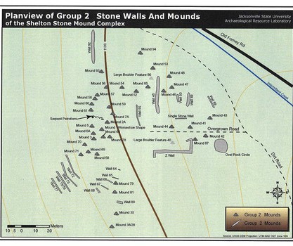
Since 2007, a team from the Department of Physical and Earth Sciences at Jacksonville State University, near Anniston, AL have been studying the stone ruins of Calhoun County, AL. The most spectacular of these complexes is located on Skeleton Mountain, southeast of Anniston, at an elevation of 1,700 feet above sea level. It has been labeled Archaeological Site 1-CA-157.
Members of the Creek and Seminole tribes were invited to the site to inspect it at the initiation of work. At least from 1500 AD until 1832, all of Calhoun County was occupied by the Creek Indians. Cherokee Indians did not enter Alabama or northwestern Georgia until after the American Revolution.
The archaeological work to date has consisted of non-obtrusive surface inspection, photography and land surveying. GPS equipment was utilized to obtain precise locations of individual stone structures. The archaeological zone was also cleaned of limbs, leaves and debris to enhance the accuracy of the photography. In the past, Skeleton Mountain was utilized as a firing range for artillery at nearby Fort McClellan. There are unexploded shells adjacent to the site. Other stone structure features may have been destroyed or damaged by exploding shells.
Several archaeological teams in the past have visited the site in the past, but more detailed study by the Jacksonville University team revealed that it was far more complex and larger than originally presumed. The ruins extended over a ridge line and new features appeared when the leave cover was removed. These unexpected features included walkways paved with stone cobbles.
The site contains free-standing walls, stone retaining walls, stone mounds, stone cairns and a pathway in the shape of a serpent. Some features, such as a horseshoe shaped wall seemed to be oriented to the solar azimuth or perhaps a view of Mount Chiaha. Mount Chiaha is Alabama’s tallest mountain. No astro-archaeologist has examined the site for its astronomical features. The second phase of study would also include excavations. The excavations would be designed to recover any archaeological data that would aid in identifying who constructed the structures, why, and when.
At this time, Dr. Harry O. Holstein, is not certain of the date that the structures were built or which ethnic group built them. However, his report expressed strong belief that these structures were probably built by indigenous peoples, and are not the haphazard piling of stones by early settlers. Jacksonville State University needs more funding before detailed studies of the region’s stone structures can be continued.