ARCHEOLOG-HOME / INDIana-UNIversitas
Contact


3D Modeling and GIS Technology
3D Modeling and GIS Technology Aid Archaeology with More Accurate Research
American Sentinel University
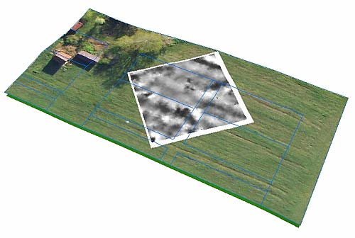
This 3D GIS image from New Philadelphia shows an aerial photo, Time Team's resistivity data, and the town's original plot lines. Photo courtesy Bryan Haley
GIS Technology Offers Great Potential as a Powerful Tool for Archaeologists and Cultural Resource Management Specialists –
We tend to think of archaeology as a discipline for shovels and artifacts, but according to American Sentinel University, 3D modeling and geographic information systems (GIS) technology are helping professionals create precise maps and landscape features to more accurately conduct research.
“The understanding and implementation of GIS adds breadth to a background in archaeology,” says Devon Cancilla, Ph.D., dean, business and technology at American Sentinel University. “GIS enables archaeologists to do their research and present their findings on a more complete and advanced scale. Having 3D modeling capabilities opens entirely new possibilities to archaeologists that weren’t there ten years ago.”
Although archaeology has traditionally been behind the technology curve and relied in the past on using the human senses more often than computers, today’s archaeologists are more adept with modern tools and analyzing computer-generated archaeological data before they ever step onto a site.
Bill Dickinson, principle GIS engineer for Exceptional Software Strategies, partly credits the spread of video games for the adoption of 3D.
“The 3D aspect of the games these days definitely makes a difference when you’re talking about the human brain being able to understand a 3D environment like Google Earth,” says Dickinson. “There is a generational learning curve when it comes to using 3D tools, with the newer generations, who have grown up with 3D and maneuvering around it on the computer, being completely comfortable exploring 3D data sets.”
A recent example of 3D mapping includes the world’s most famous shipwreck more than 25 years after its discover.
The RMS Titanic will never be raised from her resting place two and half miles under the sea, but she can be raised virtually for all to explore thanks to a new 3D map.
This April saw the first release of a ‘virtual’ Titanic, an enormously detailed interactive 3D map that will allow people who cannot afford $60,000 for a submersible dive an experience similar to diving down to the wreck itself.
In one of Dickinson’s recent projects, he took an archaeological data set from the Potomac River Basin that spread throughout Virginia, West Virginia and Maryland and plotted the information on Google Earth in 3D.
“You can immediately see that a particular site is only 50 feet from the water, or that it’s way up on the hillside far from any type of water source we know of,” says Dickinson.
Dickinson says Google Earth also allows rubber sheeting of site plan images over the top of the digital terrain.
“If I have a location and a site map, I can zoom to that location in Google Earth, bring in my JPEG image, lay it over top of the terrain, and stretch it in different ways until it fits exactly where it’s supposed to on the Earth,” he says. “You can start seeing the way particular set of archaeological data sits within the real world environment before you even head out into the field.”
In South Africa, multidimensional GIS applications have been used to model Pleistocene Caves and Paleo-Environments, reconstructing prehistoric landscape as old as 30,000 to 420,000 years ago. Researchers have also developed 3D GIS of the archaeological excavation and implemented it for the on-going excavation of the famous Biblical site of Megiddo in Israel.
The technology is also used on the popular PBS popular television show Time Team, where archaeologists use data to rebuild lost cities and sites.
It’s no surprise to Dickinson, who is an archaeologist and a GIS professional, that 3D GIS mapping has taken off over the past 10 years in the archaeology field.
“I personally think that 3D is easier for the human brain to understand, because that’s how we think normally,” Dickinson says.
The use of geographic information systems (GIS) and 3D modeling in archaeology and cultural resource management continues to grow exponentially.
GIS technology offers great potential to be a powerful tool for archaeologists and cultural resource management specialists to manage critical data and support significant archaeological digs while preserving history. This potential has created a need for specialists who can harness GIS technology to collect, archive, manage, analyze, retrieve, present and output geographic and other related kinds of data.
American Sentinel’s online Bachelor of Science Geographic Information Systems degree focuses on providing the fundamental tools necessary to employ GIS in a variety of fields, including archaeology and cultural resource management.
“GIS is one of those skill sets that is very versatile and can be used in a variety of different applications to help solve different types of problems. American Sentinel ensures that students have the solid groundwork for implementing GIS in everything from crime scene investigation to archaeology,” adds Dr. Cancilla
![]()
INDIana UNIversitas
INSTITUT SUPERIEUR D'ANTHROPOLOGIE
INSTITUTE OF ANTHROPOLOGY
ONLINE COURSES / COURS A DISTANCE
ANTHROPOLOGY / ARCHAEOLOGY
WINTER TERM : JANUARY 2014
REGISTER NOW