31 JUILLET 2015 NEWS: Despotiko - Urartu - Avebury - Myra / Andriake - Kiskiack - Dunwich - Sardaigne
INSTITUT SUPERIEUR D'ANTHROPOLOGIE
INSTITUTE OF ANTHROPOLOGY
ONLINE COURSES / COURS A DISTANCE
FALL TERM : OCTOBER 2015
REGISTER NOW
GRECE – 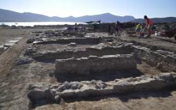 Despotiko - New excavation work at an Archaic sanctuary site on an Aegean Sea islet unearthed important findings about its size and organization, Greece’s Culture Ministry announced on Wednesday. Excavations on the small uninhabited islet of Despotiko –located off the popular island of Antiparos— have started in 1977 when archaeologists unearthed a large religious sanctuary dating to around 6th Century BC. More intensive work between May and July this year has led archaeologists to important findings about the sanctuary’s organization, the Ministry said. Findings date as far back as the 8th and 9th Century BC. The sanctuary seems to have been devoted to god Apollo, as the traces of religious worship indicate. So far, archaeologists have discovered 13 building structures but the latest finding, an ornate facade of a structure measuring 35 meters by 15 meters, is of great importance, the Ministry said. It suggests that the sanctuary was extended and rebuilt several times during the Classical and Hellenistic periods. Among the archaeologists‘ new discoveries is a large, four-room building on the site’s west section. A large stone altar was found in one of the rooms as well as pottery fragments bearing inscriptions with Apollo’s name. Another important discovery is a long wall stretching from what would have been the islet’s ancient port to the site of the sanctuary. Archaeologists believe the wall would have served as fortification.
TURQUIE – 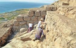 Urartu - After 2700 years the walls of Urartu Castle have been unearthed in the Ayanis neighborhood of the eastern province of Van. Excavations at the Urartu Castle site, situated 38 kilometers from Van, have been ongoing for 25 years, leading to new discoveries every day. After the discovery of the temple, this year the walls, a defining part of the castle, have been unearthed. Some 25 years after the construction of the castle it was damaged by an earthquake and a fire, which was followed by the dismantlement of the adobes and hence the closure of the castle, Head of Excavation Doç. Dr. Mehmet Işıklı said. “Excavations at the castle have been going on for years. We have regained many important artifacts for the museum. However, 2,700 years after the construction of the castle the most enticing part of the castle, the walls, have been discovered. This made us very excited, as even though these walls witnessed great earthquakes, their architecture remained quite robust and unchanged. Also we learn so much about the history of Urartu from the walls. Lastly, even the earthquake in 2011 with a magnitude of 7.2 didn’t harm the building. The Ayanis Castle is full of surprises,” Işıklı added.
ROYAUME UNI –  Avebury - Archaeologists believe they may have found the remains of a house where people who built Avebury stone circle may have lived. The three-week Between the Monuments project is researching the daily lives of Neolithic and Bronze Age residents at the Wiltshire site. Spokesman Dr Nick Snashall said: "I could count the number of middle Neolithic houses that have been found on the fingers of one hand. "This site dates from a time when people are just starting to build the earliest parts of Avebury's earthworks, so we could be looking at the home and workplace of the people who saw that happening." The site being excavated is next to the West Kennet Avenue - a 1.5-mile (2.5km) prehistoric avenue of two parallel lines of stones - and was first discovered by archaeologist and businessman Alexander Keiller 80 years ago. The team has spent three years researching his journals and drawings together with modern geophysical survey techniques to pinpoint the excavation area. They have also discovered arrowheads, clusters of scrapers for working hide and plant materials, miniature flint saws and pottery.
http://www.bbc.co.uk/news/uk-england-wiltshire-33686240
TURQUIE – 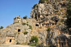
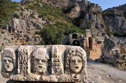 Myra / Andriake - This year’s excavation works have begun in the ancient site of Myra and the Andriake Port situated in Demre district of Turkey’s southern resort province of Antalya. Six of the most important ancient sites of the Lycian Union lie in this area, where excavations kicked off in 2009. The initial excavation team was led by Professor Nevzat Çelik of Akdeniz University’s Archaeology Department. However, another team, led by Professor Nurettin Öztürk from Erzurum University’s Archaeology Department, has taken over the excavation in the past two years. The team, consisting of nine scientists, including colleagues from France, 26 archaeology students and four workers, will continue their excavations in the Calidarium (hot room) section of the ancient Roman bath, which dates back to the 2nd century. The team will also unearth artifacts from the front of the Andriake Port’s Granarium (grain storage) part. In September, the team will focus on the Myra Castle. Professor Öztürk stated that the works have been carried out with a 7 to 8 meter-long barrier. The history of the ancient site of Myra dates back to 5th century B.C. The site has made a name as a metropolis of the Lycian Union, where Saint Nicholas (later known as Santa Claus) lived and was buried. The theatre of Myra can host 13,800 people; archaeologists have been surprised by theater masks unearthed during the excavations. The ancient site has survived until present-day without undergoing any restoration.
USA – 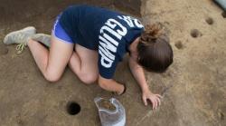 Kiskiack - The hearth feature was one of the top finds of the summer archaeological field school conducted by Professor of Anthropology Martin Gallivan at Kiskiack, the site of an Indian town that was once part of the chiefdom of Powhatan, the father of Pocahontas. It’s possible that John Smith or Pocahontas ate a meal cooked on the very same hearth that Gunter and Bittner were excavating, but it would be fanciful to say so. Gallivan says that the odds of both time and place are against such an occurrence. Kiskiack may have been occupied for centuries at the time that Smith and the other Jamestown colonists arrived in 1607. In addition, the site extends for hundreds of yards along a bluff overlooking the York River, on the grounds of what now is Naval Weapons Station Yorktown, and no doubt the ground underneath contains many, many hearth features of various vintages. The archaeologists hope that laboratory examination of the hearth area will not only help to date the feature, but also yield up clues about what was eaten there at the time. The hearthstones are lumps of quartzite, brought down the York River from Virginia’s mountains by long years of weathering and flooding. Some of the hearthstones look like brick fragments, but they’re not. “You see these red stones, here?” Gunter asked. “That’s one of the indications that it’s a hearth feature, because when these rocks are exposed to a certain temperature, they turn this red color.” As hearths tend to be a central aspect of Indian domestic life, the material recovered from between the stones can be more interesting than the hearthstones themselves. Hearth sites tend to be associated with debitage, an archaeologist’s term for the flakes left in the production of stone tools, Gunter explained. Everything that comes from the hearth feature is carefully extracted, using spoons and then brushes. Everything is saved, too.
ROYAUME UNI – 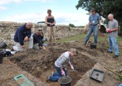 Dunwich - Cambridge archaeologists and the Touching the Tide Heritage Lottery Funded project has linked up for a major archaeological dig at various sites around Dunwich - Suffolk's famous "lost city" that has been reduced to a few properties by coastal change. A community archaeology project is starting to shed new light on one of East Anglia’s most compelling stories of colossal coastal change – the medieval decline of Dunwich from a proud, internationally important port to a place of abandonment and abject poverty. Most of Suffolk’s famous “lost city” lies beneath the sea and sediment up to a kilometre offshore from the now much-loved remnant hamlet that Dunwich has become. Divers using hi-tech techniques have carried out seabed studies in recent years and now Access Cambridge Archaeology, part of the University of Cambridge’s Division of Archaeology, is undertaking a nine-day dig at sites around the hamlet. It is hoped that centuries-old secrets that help tell the true story of the major port’s fall from grace will be revealed and that members of the existing local community will be involved and inspired to learn more about their area’s extraordinary history. “The story of Dunwich is a classic one as far as coastal change goes but most people’s understanding of that story is framed by a few photos taken between the late 19th Century and about 1913 of All Saints’ Church on the cliff edge before it went over,” said Mr Jenman. “That gives them the perception that the story is all about coastal erosion but before that time, at the tail end of the 1200s and into the 1300s, there were massive storm surges that had massive effects. Dunwich then had a population of about 4,000 people and 400 houses would have gone in just one night of a sea surge. Over time the harbour was blocked by shingle and silted up – the whole economic rationale for Dunwich’s existence was gradually lost. “It is a classic example of coastal change, but it wasn’t just down to erosion. Dunwich declined with abandoned houses, lots of poverty and probably lawlessness. It happened at a time of unstable climate and unstable climate means massive storms – maybe that is something that has a resonance for us today.”
http://www.ipswichstar.co.uk/news/digging_begins_in_a_bid_to_uncover_suffolk_s_lost_city_1_4175405
ITALIE – 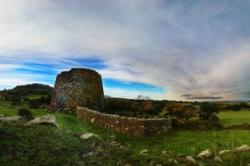 Sardaigne - Sardinia’s archeological treasure - 8,000 nuraghi, ancient megalithic buildings found nowhere else in the world - is now available online for everyone to enjoy thanks to a newly created website, ArkeoSardinia, available in Italian and English. The website displays 50 of the most beautiful and interesting archeological sites, each with a description, photos (many from up above), a map, and nearby places of interest, including practical information, such as hotels and restaurants. Browsing the site, you can discover such gems as Nuraghe Arrubiu (Orroli, Nuoro), possibly the largest nuraghe, along with Su Nuraxi (Barumini, Cagliari); you can explore the Tombs of the Giants Li Lolghi e Li Muri at Arzachena (Sassari); you can be captivated by the mystery of the Tophet found in the urban area of Tharros (Cabras, Oristano)... was it a sacred burial place for children or a place where human sacrifices took place? The large amount of digital content documents a long history that goes from 5,000 BC to the 2nd century AD. The Nuragic civilization began in the Bronze Age (1800 BC), as the evolution of pre-existing cultures present on the island of Sardinia since Neolithic times. The Nuragic civilization takes its name from nuraghi, circular defensive towers in the form of truncated cones built of dressed stone for which no parallel exists anywhere else in the world. Nuraghi were discovered in the 1930s and were recognized a UNESCO World Heritage site in 1997.