
29 MARS 2024 NEWS
INSTITUT SUPERIEUR D'ANTHROPOLOGIE
INSTITUT OF ANTHROPOLOGY
COURS ONLINE – COURS A DISTANCE
INSCRIPTIONS OUVERTES
REGISTER NOW
CHILI – Rapa Nui - Traces of Breadfruit and other South American crops found recently discovered early settlement on Easter Island , Rapa Nui, point towards regular contact between South America and the island territory over 1000 years ago, a new study finds. The peer-reviewed study from Journal Plos One, published on March 20, claimed that researchers discovered the food remnants by identifying starch grains on obsidian blades discovered in 1987. Other vegetable remains found in the study include ginger, taro, yam, and sweet potato. This discovery happened at the archaeological site Anakena, the earliest known settlement on Easter Island, inhabited from around A.D 1000 to 1300. Understanding the food culture on the island during this time period suggests that these earlier Polynesian settlers had regular contact with mainland South Americans over a millennium ago. "The detection of Ipomema Batatas (sweet potato) from this site in Rapa Nui constitutes the earliest record of this cultigen in the Pacific. "Scientists know early settlers consumed fish, dolphins, seals, chicken, and rats. However, plant remains have not been thoroughly investigated.
INDE – 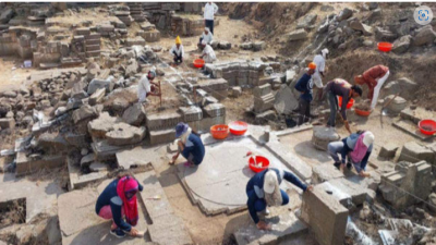 Ambajogai - Reports add that the Archaeology department of the Maharashtra government made a significant discovery, which was revealed by an official in the know-how. They have discovered two temple bases in the Sakleshwara temple premises, also known as the Barakhambi temple, which dates back to 1228 AD, constructed by the Yadava dynasty, rulers of the Devgiri Fort, as per an earlier-found inscription. "The excavation commenced on March 15, with the creation of 14 trenches spanning 100 square feet each. Among the findings are the foundations of two temples, one identified as Kholeshwar, named after a Yadava general," shared Amot Gote, Assistant Director of State Archeology. The discoveries include fragments of bricks indicating the presence of shikharas (towering spires) atopGote explained, Ambajogai, formerly known as Amrapur, Jayantipur, and Jogaiambe, has a rich historical background. During the Hyderabad Nizam Era, it was recognized as Mominabad, he explained. He further noted the presence of other notable monuments in the region, including Hatthikhana, Dasopant Temple, and Yogeshwari Temple. these temples, along with sculptural elements, such as hands and feet.
Maharashtra Temples: Two temple foundations unearthed during excavation in Ambajogai | Times of India Travel (indiatimes.com)
TURQUIE – 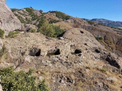
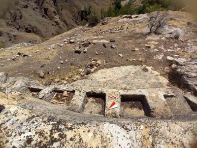 Tunceli - Two fortress settlements and two new open-air temples were discovered during a survey in Tunceli province in the Eastern Anatolia Region of Türkiye. Two fortress settlements and two new open-air temples discovered during the survey were published in the 61st issue of the Pamukkale University Social Sciences Institute Journal. Associate Professor Serkan Erdoğan noted that one of the newly discovered castle settlements is located in the easternmost part of today’s Tunceli provincial borders and the other is almost in the westernmost part of these borders. “The two fortress settlements, one named Masumu-Pak fortress located in the Hozat-Çemişgezek -Ovacık triangle and the other named Aşağı Harik (Doluca), located on the banks of the Peri Çayı (Peri stream) east of Nazımiye in the southeastern Anatolian region host a new type of temple that we have not known before,” he stated. Researchers noted that While the Iron Age traces are intense in Aşağı Doluca Fortress (Lower Doluca Fortress), the Iron Age and Medieval structures are evident in the Masumu-Pak Fortress. It has been established that the buildings regarded as open-air temples in the settlements of Aşağı Doluca Fortress and Masumu-Pak Fortress share similar form and construction characteristics. The primary similarity between the outdoor prayer spaces in the two communities is the architectural feature that resembles an altar etched into the rocks, with a platform in front of it. Researchers said that the temples showed that they were built in a period of 7 centuries BC (9-8 centuries BC) when Urartian dominated the region. The question of whether these temples, which have local characteristics, were built for local gods/cults or the worship of the known great gods of a certain period, remains unclear. Assoc. Dr. Serkan Erdoğan said, “The Lower Harik Castle and Temple, located in today’s castle hamlet settlement, is also known as a sacred place called Moro Sur (Red Snake). “Today, those who still want to find healing continue to call out by saying “Ya Moro Sur, Tu esta (You exist, Moro Sur),” he said. Emphasizing that the snake motif is affirmed in geography, Assoc. Prof. Dr. Erdoğan stated that the Moresur myth has an original and authentic structure and that the history of this area as a sacred place dates back to ancient times.
ISRAEL – 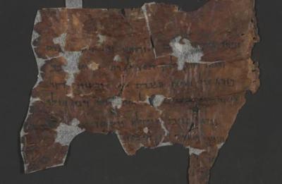 Judean desert - One of the most interesting and mysterious scrolls discovered in the Judean Desert is a scroll called the “Horoscope.” This scroll shed light on the ancient practices of astrology and mysticism in a discovery that has intrigued historians and archaeologists alike. The artifact offers a unique peek into the beliefs of a secretive sect that thrived thousands of years ago. This ancient text reveals a worldview in which a person’s birth date not only indicates their zodiac sign but also determines their physical characteristics and the balance of light and darkness within their soul. This unique composition was written in Hebrew in the reverse direction – from left to right- and contains signs in Greek, Aramaic, and ancient Hebrew script, as well as code. “From the writing style, it seems the text was intended only for those who were supposed to know how to read it,” says Dr. Oren Ableman, a scroll researcher in the Judaean Desert Scrolls Unit of the Israel Antiquities Authority. “The texts were apparently secret, comprehensible only to the leadership of the Scrolls sect.” The scroll presents an intriguing theory in which a person’s physical attributes are determined by the degree of light or darkness in their soul. Each date on the calendar is associated with a particular amount of light or darkness, and thus, the amount of good or evil, or light or darkness, in the soul of the person born on that date. The “Horoscope” scroll also hints at a rigorous initiation process for new members of the community, who identified themselves as “children of light.” “It seems to have been a kind of manual for crafting a ‘horoscope,’ using one’s birth date to determine their personality and physical features. New members had to prove their suitability to join the ranks of the righteous. This, in effect, suggests that a person could believe in the sect’s beliefs and customs but still be rejected because they were not born on the right date, or their head shape did not fit,” says Dr. Ableman. The discovery of the scroll has reignited interest in the Dead Sea Scrolls and ancient Judean Desert sects, serving as a reminder of humanity’s enduring quest for knowledge and the mystical.
The “Horoscope” Scroll Found In the Judean Desert: A Glimpse Into the Mysterious Sect - Arkeonews
TURQUIE – 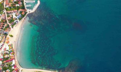
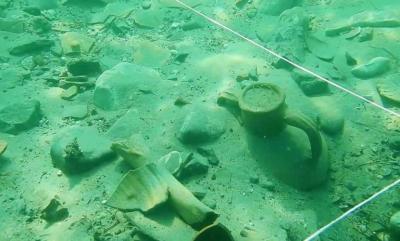 Kerpe - Ancient Kerpe Bay is situated in Kandıra, a district of Kocaeli, which has the longest coastline along the Black Sea (52 km) in Turkey . Kerpe is located in the bay protected from northerly winds and Black Sea surges. Kerpe was known as “Kalpe”, which means “pot, jug, jug, jug” in the Hellenic language. It is an old and important place, dating back to the fifth century B.C. Kerpe Bay, a naturally protected port on the Black Sea coast, was used as an emporium (upp-market) and coastal town in the seventh century by colonists from Miletus or Megara to use and protect Black Sea trade routes. After the collapse of the Bithynia kingdom, the Kerpe settlement continued in Eastern Roman and Western Roman periods as well due to its strategic position. In addition, it developed into a stop for the Genoese ships and served also as the route for wood and wood coal transport to Istanbul during the Ottoman period. The remains of the pier belonging to the Ancient Kalpe Harbor were mostly submerged underwater, leading to underwater excavation works initiated in 2020. The excavation team worked 80 meters away from the shore at a depth of 4 meters to reach the remains scattered over an area of approximately 2,000 square meters. During the excavations, they unearthed two parts of the ancient pier and numerous remnants of amphorae (two-handled pottery typical of the ancient period) from underwater. During the excavation works, we have identified many underwater cultural heritages, ranging from commercial amphorae remains dating from the 4th century BC to the 12th century AD, to red-glazed ceramics, lamps, pipe fragments, various cultural assets belonging to the Ottoman period and shipwreck remains that we have detected in the region.”
ALLEMAGNE – 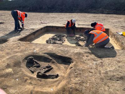 Eulenberg - There had always been something slightly curious about the terrain of the Eulenberg industrial area outside Magdeburg, the capital of Saxony-Anhalt There’s a small hill, not particularly high, but certainly an outlier in an otherwise flat and far-stretching landscape The hunch proved correct. LDA has identified a Neolithic burial ground dating back 6,000 years that contains human and animal remains. The site been connected with Baalberg culture that lived in the region between 4100 and 3600 B.C.E. The name derives from Baalberg, the site at which such culture was first find. The culture grew wheat and barley, raised pigs, sheep, and goats, and is associated with undecorated stone and earthen wares. Of particular interest to archaeologists are two monumental burial mounds, approximately 650 feet from each other. Both were built above wooden burial chambers (66-feet by 98-feet) and both contained several burials. A corridor linking the two mounds together points to a ritualistic procession. Along this path archaeologists found a pair of young cattle and a 35 to 40-year-old man. Together, they create the image of a cart with a driver or a plow pulled by cattle. It’s a practice known from other period burial sites in the region. It has been associated with Globular Amphora culture (roughly 3300 to 2800 B.C.E and points to a group offering their most valuable possession to the gods. Archaeologists found a foot-and-a-half wide ditch running along the procession route. It dates from around 1,000 years after the burial. Nearby, the team also found burial mounds connected to Corded Ware Culture, which date to between 2800 and 2050 B.C.E.
The Site of a Proposed Intel Plant Sits Atop Neolithic Burial Mounds (artnet.com)
GRECE – 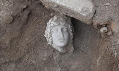 Philippi Kavala - The excavation, carried out by a group of students of the Aristotle University of Thessaloniki in the archaeological site of Philippi Kavala, brought to light important findings. Among other things, they discovered a rare head of Apollo dating back to the 2nd or early 3rd century AD. The statue dates back to the 2nd or early 3rd century AD and it probably adorned an ancient fountain. Archaeologists say, this year the excavation continued east of the southern main road (decumanus) at the point where it meets the northern axis of the city (the so-called “Egnatia”). The continuation of the marble-paved road was revealed, on the surface of which a coin (bronze phyllis) of the emperor Leo VI (886-912) was found, which helps to determine the duration of the road’s use. At the point where the two streets converge, a widening (square) seems to have been formed, dominated by a richly decorated building. Archaeologists say evidence from last year’s excavations leads them to assume it was a fountain. The findings of this year’s research confirm this view and help them better understand its shape and function. The research of 2022 brought to light part of the rich decoration of the fountain with the most impressive statue depicting Hercules as a boy with a young body. The recent excavation (2023) revealed the head of another statue: it belongs to a figure of an ageneous man with a rich crown topped by a laurel leaf wreath. This beautiful head seems to belong to a statue of the god Apollo. Like the statue of Hercules, it dates from the 2nd or early 3rd centu ry AD and probably adorned the fountain, which took its final form in the 8th to 9th centuries.
The marble head of God Apollo unearthed in an excavation at Philippi, Greece - Arkeonews
PERSIAN PLATEAU – 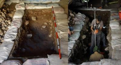 Pebdeh Cave - 60,000 to 70,000 years ago, our species Homo sapiens walked out of Africa and began to find new homes around the world. Despite the enormous importance of this era, we know surprisingly little about where people were living when they first ventured out into the world, which was between 70,000 and 45,000 years ago. Homo sapiens walked out of Africa, what happened next? Well, hidden clues can be found in our genes, according to a new study. A recent multidisciplinary study has by looking at ancient and modern DNA, revealing that the Persian Plateau played a fundamental role as a hub for early Homo sapiens who expanded beyond their African homeland. Thanks to a combination of genetic, palaeoecological, and archaeological evidence, scientists have uncovered that the region surrounding modern-day Iran likely provided a “home away from home” for around 20,000 years, allowing a significant population of Homo sapiens to build up and thrive before they dispersed across Eurasia and beyond. Professors Luca Pagani and Michael Petraglia’s team of researchers used a novel approach that combines genetic data with paleoecological models to reveal that the Persian Plateau, located in southwest Asia, emerged as a favorable habitat capable of supporting a significantly larger human population than other areas of western Asia. This means that the ancestors of all modern non-Africans spent approximately 20,000 years on the Persian Plateau following their migration out of Africa. In other words, if you have genetic ancestors from Europe, Asia, the Americas, or Oceania, some of them most likely spent significant time in this region.“We looked at the timing of the movement of Homo sapiens out of Africa and concluded that Iran and the Persian Plateau played a very big role in that,” said Michael Petraglia, an archaeologist from Griffith University and one of the authors of the paper. “The discovery elucidates a 20,000-year-long portion of the history of Homo sapiens outside of Africa, a timeframe during which we interacted with Neanderthal populations, and sheds light on the relationships between various Eurasian populations, providing crucial clues for understanding the demographic history of our species across Europe, East Asia, and Oceania,” first study author Leonardo Vallini, of the University of Padova in Italy, said in a statement.
CHINE- 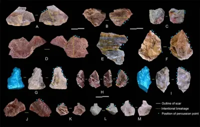 Cenjiawan - An international research team led by Chinese scientists has found that East Asian hominins had possessed advanced stone tool technology as early as 1.1 million years ago, much earlier than previously thought. This was reported by The Xinhua News Agency. The team, led by the Institute of Vertebrate Paleontology and Paleoanthropology (IVPP) of the Chinese Academy of Sciences, carried out systematic study on the characteristics of stone tool technology at Cenjiawan site in Nihewan basin, northern China, revealing the earliest prepared core technology in Eurasia. nAccording to technical analysis and high-precision 3D scanning of stone tools at the site, the research team revealed how hominins at the site made and used stone tools. The results show that prepared core technology had existed at the site. Prepared core technology is an important part of Acheulean industry, the first standardized tradition of toolmaking of Homo erectus and early Homo sapiens. The research team believes that the hominins at the Cenjiawan site had similar cognitive level and technical ability as the Acheulean hominins. "The study is of great significance to the study of the evolution and innovation of early Paleolithic technology", – said Pei Shuwen with the IVPP, one of the corresponding authors of the study. "It shows the great potential of Nihewan basin in the research field of constructing the development model of human evolution and behavior in East Asia for millions of years", – Pei said. The study was published in the journal Proceedings of the National Academy of Sciences of the United States of America (PNAS).