ARCHEOLOG-HOME / INDIana-UNIversitas
Contact


29 - 31 DECEMBRE 2010
- 30 DECEMBRE :
- YEMEN : 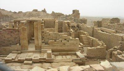 Al-Mouton - An old archaeological site has been found in al-Mouton district in Jawf governorate during the construction of a water network. The archaeological site represents an old passage in a road consisting of rocks and antique pillars containing historical drawings and inscriptions. A specialized team is expected to survey the site to find more about the unexpected archeological place, he pointed out.
http://www.sabanews.net/ar/news232023.htm
- ERYTHREE : Mai-Ghebro - The Eritrean National Museum has discovered a jaw and teeth of a missing link of an extinct elephant family, as well as human frontal lobe and chick bone in both the Northern Red Sea region and the Southern region. In a press conference he gave, the Head of the national museum, Dr. Yosef Libsekal, explained that the discoveries were made during field studies conducted on December 2010 through Eritrean and Italian archeologists. He further indicated that the fossils of the extinct elephant family were unearthed at the site of Mai-Ghebro near Mendefera town in the Southern region, while the remains of human frontal lobe and chick bone was discovered at the site of Mulhuli-Amo in Ma'ebele area, Northern Red Sea region. The director of research division at the Eritrean National Museum, Mr. Tsegai Medhin, said on his part that the newly found fossil of a missing elephant family is estimated to be 27 million years old and is of the first of its kind both in terms of age and species. Moreover, a systematic research undertaken by the Eritrean-Italian team of archeologists in the villages of Buya (Homo site), Me'abele, Dioli, Derayto and Dandero revealed a significant evidence regarding the geological evolution of the Rift Valley and the ancient environment in which our ancestors lived.
http://allafrica.com/stories/201012290004.html
- ALGERIE : Tlemcen - Trois nouveaux musées devant exposer les trésors archéologiques et le patrimoine que recèle la capitale des Zianides lors de la manifestation “Tlemcen, capitale de la culture islamique 2011″, sont actuellement en chantier à Tlemcen. Un musée de monuments islamiques mitoyen de l’ancien musée de la ville de Tlemcen, situé dans la vieille école, servira à exposer des pièces archéologiques et vestiges historiques, découverts lors d’opérations de fouilles et de prospection, menées récemment par des équipes spécialisées. Ces fouilles ont touché divers sites historiques de la ville de Tlemcen notamment “Agadir”, qui comprend les ruines et le minaret de la plus ancienne mosquée au Maghreb, ainsi que la citadelle du Mechouar qui comprend le Palais royal des rois des Zianides. Le deuxième musée est situé, selon le même responsable, à l’école de Sidi Belahcene et sera consacré à l’exposition des manuscrits et livres anciens dans diverses disciplines de la science, de la littérature et des traductions, qui sont l’oeuvre d’un grand nombre d’érudits de Tlemcen et des villes historiques avoisinantes. Le troisième musée en chantier également au niveau de l’ancien siège de la mairie deTlemcen (centre-ville), sera un espace pour la présentation des arts de la civilisation islamique, qui ont marqué certaines dynasties qui se sont succédées aux pays du Maghreb tels que les Zianides, Mérinides et Almohades.
- TUNISIE : El-Haouaria - Les grottes d'El Haouaria (gouvernorat de Nabeul) sont désormais classées site culturel. Ces grottes sont, en effet, des carrières antiques dont l'exploitation a débuté au plus tard au VIIe siècle avant J.C. La pierre de grès a longtemps servi à la construction des monuments de Carthage la punique et ensuite, la romaine. Le mode d'exploitation de cette carrière était assez original et rare. La technique consistait à extraire la pierre de l'intérieur de la masse pour la faire parvenir en surface par le biais de puits de montée carrés. Ces carrières sont mentionnées par des sources antiques à l'exemple du géographe et historien Strabon ou Diodore de Sicile. Le site culturel des grottes d'El Haouaria connaît depuis peu des interventions de restauration et de mise en valeur, visant à protéger les grottes et toute la zone archéologique limitrophe.
http://fr.allafrica.com/stories/201009030534.html
- MAROC : Rétrospective des évènements 2010 : 16 avril 2010 -Découverte de vestiges de la civilisation atériennes qui remonteraient à environ 175.000 ans dans la grotte préhistorique d'Ifni n'Ammar, située dans la commune d'Afsou, à environ 50 km au sud de la ville de Nador.Cette découverte a été effectuée par des archéologues de l'Institut national des sciences de l'archéologie et du patrimoine (INSAP) et de l'Institut allemand d'archéologie (KAAK, DAI).
http://www.casafree.com/modules/news/article.php?storyid=54063
- 29 DECEMBRE :
- INDE : Hampi - Archaeologists from Bangalore discover maps near Hampi; unlike modern maps that rely on technology, ancient man banked on his eyesight and memory. A team of researchers from Bangalore have unearthed maps in Karnataka that date back to 1500-2000 BC. A team from the Archaeological Survey of India has found the proto-historic man, who had inhabited the region around Tungabhadra river near Hampi, had drawn maps. The map was depicted on the roof of their cave dwellings. What was once thought to be a megalithic burial site with just paintings of animals and humans, is proof of the proto-historic man’s cartographic skills. While paintings of animals such as cows, hunting scenes and human figurines are common across pre-historic settlements, only the Chikramapura village caves, also called Kadebagilu rock shelters, feature maps. The pre-historic man obtained a bird’s eye view of an area by climbing a hillock and standing at a vantage point. He would then observe his settlement — houses, pathways, waterbodies, etc. With these images in mind, he would paint them in his cave. Deciphering the exact meaning of the paintings was not easy for the experts. Reaching the site itself was an arduous task as it was surrounded by a hillock overlooking a valley and accessible only through a narrow passage. Researchers found many similarities with the modern-day maps. The triangular marks used to represent hillocks on these maps are similar to the symbols used by surveyors. Further, the narrow passage has been compared to the figure of a human being, while the ladder-like symbol indicates a pathway. It took Keshava and his team almost a year to confirm the findings.The paintings have been depicted on granite and done with red laterite clay. The circular-shaped settlement is 35 metres in radius.
- SYRIE : 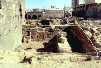 Daraa - The foundations of a Church's wall near the southern side of the Roman Temple in the old site of Daraa province were excavated by Daraa Archaeological Department. Mohammad Kheir Nasrallah, the Department's Director, said the church, based on the unearthed pottery fragments, goes back to the 5th and 6th centuries A.D. He added that the 15 m long and 7, 5 m wide church was built in the Basilica style, pointing out that the building date of the church has not yet been specified due to the absence of any kind of inscription.
- U.S.A. : Beaufort - An ancient, nearly forgotten facet of Beaufort County’s past made news this year as an effort to find a lost, internationally famous Indian village gained momentum — and critical allies. The search for this village, known as Secotan, capital of an Algonquian nation, has drawn the interest of leading regional historians, archaeologists and local and state officials. Secotan was made famous in watercolors painted in 1585 by English gentleman John White. Beasley Point, which is owned by Canadian phosphate-mining company PotashCorp, is the most viable candidate for Secotan, based on a centuries-old map and artifacts unearthed on the property roughly a quarter-century ago. It was the capital of the Secotan nation. The Secotan nation ran from about the Chowan River down to the Neuse River.
http://wdnweb.com/articles/2010/12/28/news/doc4d1914f457c1a790747065.txt
- IRAN : 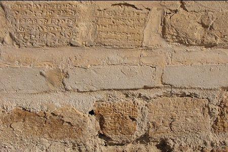 Suse - Experts have warned about natural and environmental dangers threatening Iran's Susa Castle in the country's southwestern Khuzestan Province. Erosion, heavy showers and strong winds have endangered the structure. The castle boasts many inscriptions some of which are engraved on building blocks of the monument and are threatened by natural and environmental factors. Lack of a strong foundation has caused cracks of various sizes in different part of the building, mortar rounds and bombs that hit the surrounding area during the Iraq-Iran war also caused serious damages to the structure. Unprofessional restoration projects conducted over the past few years have damaged the authentic look of the monument. According to a report published in 2007, about 90,000 artifacts are kept in nonstandard conditions in the underground storerooms of the Susa Castle. The relics belong to different eras of the ancient Persia and include artifacts discovered by French archaeologist Roman Ghirshman in the 1940s. Located on a hill near the ancient city of Susa, the Susa Castle was built by French civil engineer, geologist and archaeologist Jacques Jean-Marie de Morgan (1857-1924), who carried out excavations in the region. To build the monument, De Morgan used ancient bricks which had been scattered at nearby archeological sites such as Haft-Tappeh and Tchogha Zanbil. The construction of the castle which began in 1897 was finished under the supervision of Iranian architect Mostafa Dezfouli in 1912.
http://www.presstv.ir/detail/157611.html
- INDE : 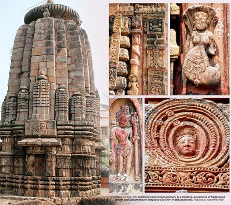 Bhubaneswar - From architectural splendour to stunning pilaster motifs, the 10th century Subarneswara and Nageswara temples situated in the Kotitirtheswar lane of Old Town have every characteristic of becoming a prominent heritage site. However, lack of concern of authorities and even the public, has led to the neglect of the beautiful monuments. The temples are located on the left bank of the Lingaraj west canal. The Subarneswara temple is believed to have been built by the kings of the Keshari period. Built in light grey sand stone, the temple is a perfect example of the mastery of sculptors and architects of ancient times. The outer wall of the monument is adorned with small temple shaped pillars. Similarly the Nageswara temple that stands opposite to it is decorated with mystic creatures and figurines carved on the pilasters that add to the ornamentation of this 10th century structure. Striking sculptures of snakes and demi-gods representing the snake family are also found on the walls of the richly carved Nageswara temple, which is built, in fine-grained ochre sand stone. Some local residents have been taking care of the temples where all major rituals and daily worship is carried out.
http://www.telegraphindia.com/1101229/jsp/orissa/story_13364242.jsp