ARCHEOLOG-HOME / INDIana-UNIversitas
Contact


28 - 29 JANVIER 2012 NEWS : Escalles - Herodium - Etreham - Zagora - Shiur - Narbonne -
28 - 29 JANVIER
INDI-UNI : ANTHROPOLOGY - ARCHAEOLOGY
INSCRIPTION 2012 COURS A DISTANCE
REGISTRATION 2012 ONLINE COURSES
FRANCE –  Escalles - Le conseil général du Pas-de-Calais, dans le cadre de la mise en valeur et de la protection du site des Deux-Caps, souhaite créer un parking semi-enterré au Mont d'Hubert, à Escalles (photo ci-dessous). Une équipe de scientifiques du centre départemental d'archéologie, placée sous la responsabilité de l'INRAP, a travaillé sur le site à l'automne 2010. Elle est revenue au printemps 2011 pour fouiller les vestiges découverts dans un camp de hauteur, délimité par un fossé barrant le sommet et datant de 4 000 ans avant J.-C. Dans la région, ces traces sont extrêmement rares selon les experts. Trois sites abritant des vestiges du néolithique ancien sont recencés dans la région, une vingtaine du néolithique récent sont comptabilisés, plus une vingtaine de sites du néolithique moyen, dont fait partie Escalles. Au Mont d'Hubert, la découverte du site « relève du miracle, car il faut rendre hommage aux archéologues qui ont trouvé des informations dans un site bombardé par les Allemands » selon Ivan Praud, responsable des opérations à l'INRAP. Le site est exceptionnel car il renferme un système d'enclos fermé par des fossés, des levées de terre et des palissades. « Dans le Nord - Pas-de-Calais, deux implantations de fond de vallée sont connues à Carvin et Lauwin-Planque, poursuit le chercheur. Le Mont d'Hubert est localisé à l'extrémité des collines d'Artois et occupe une position originale d'altitude. Il domine un vaste secteur dont le Cap Blanc-Nez et le détroit du Pas-de-Calais, qui offre dans un rayon de 30 km une vue dégagée sur les côtes anglaises. » Selon Ivan Praud, l'un des enjeux des découvertes faites à Escalles est de savoir si « les communautés du Néolithique ont traversé le détroit. Peut-être qu'on trouvera des preuves d'échanges. La question est de savoir quel est le rôle du site d'Escalles dans la néolithisation de l'Angleterre ? » Les recherches qui se poursuivent en laboratoires permettront peut-être d'avancer une hypothèse. Les archéologues devront publier leurs conclusions dans un rapport attendu en 2013. « L'enjeu de notre travail est de retrouver la trace de populations anciennes qui n'ont pas laissé de traces écrites ». Les travaux complémentaires aideront-ils à comprendre le choix de ce site stratégique, sur les hauteurs d'Escalles ? « S'agissait-il d'un site défensif, de la place centrale d'un territoire, d'un lieu occupé par saison ? Ont-ils choisi ce site pour voir ou pour être vus ? » •
ISRAEL – 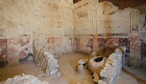 Herodium - An unusual plan to rebuild the tomb of Herod the Great at the Herodium site, southeast of Jerusalem, has spurred opposition on the part of top archaeologists. The plan, which is being promoted by the Israel Nature and Parks Authority and the Gush Etzion Regional Council, includes building a lavish mausoleum in its original size out of light plastic material, and turning it into a visitor’s center. The plan is the first of its kind in the realm of Israeli archeological digs, as most sites consist of either miniaturized or renovated historical sites that use the original materials found at the site. Herod’s grave was discovered approximately five years ago by the archaeologist Ehud Netzer, who died two years ago as a result of a fall at the site. Before his death, Netzer was able to recreate the tomb, which reached a height of 25 meters and prided itself on having a cone-shaped roof. A model of the structure, which reached a height of 4 meters, was built at a cost of NIS 50,000 and was placed at the site last week, “It’s crazy - Archaeology is not Disneyland,” said one top archaeologist. Archaeologists doubt the certainty of the tomb’s location and of the sketch of the structure that was built atop it. Herod the Great ruled over the Judean Kingdom in the first century BC, and died in 4 AD. He was responsible for rebuilding the Second Temple, as well as building Caesarea and Masada.
FRANCE – 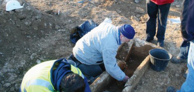 – Etreham - Les travaux de terrassement engagés sur la commune pour dévier la circulation devant l’école d’Etréham ont mis à jour, à proximité de l’église, un sarcophage où reposaient ensemble un squelette d’enfant et celui d’un adulte. Le chantier a été stoppé et le service archéologique a débuté des fouilles lundi 16 janvier. Vincent Hincker et deux autres agents du service archéologique du conseil général ont découvert un cimetière. Le lieu était connu. “Déjà en 1922, lors de la pose du monument aux morts, deux sarcophages avaient été découverts. Ils ont été conservés à l’église de Trévières”, explique le maire, Alain Cornières. Les archéologues ont découvert trente-sept tombes. “Il s’agit d’un cimetière du VIIe siècle allant jusqu’à la moitié du VIIIe siècle”, indique Vincent Hincker. Cette découverte permet d’apprendre beaucoup sur la vie à cette période. Si le Département et la commune décident d’engager des fouilles plus importantes, celles-ci pourraient être menées en mars pour une durée de deux mois.
http://www.lamanchelibre.fr/actualite-33059-mise-a-jour-dun-cimetiere-du-viie-siecle-a-etreham.html
GRECE – Zagora - The excavation and study seasons at the archaeological site of Zagora on the island of Andros from 1967 to 1977 have proved to be fundamental for the study and reconstruction of life in the Aegean during the Geometric period and the distinguished specialist, the late Professor Nicolas Coldstream commented on the site as follows: “…. no other place in the Greek world offers a clearer picture of domestic life in this period” (Geometric Greece, 2003, p.210). Zagora kept its significant position up to our own days like no other excavated settlement of the same period. Inevitably, however, a great deal of relevant material has been revealed in the past few decades which greatly enhances our understanding of the Greek world during the 9th and 8th centuries B.C. The aim of this conference is to highlight the new discoveries, emphasize their contribution to a better understanding of the excavations at Zagora, and a better interpretation of the archaeological material that was revealed at that site. More precisely the aims of the conference is to examine the similarities and differences between the settlements of the Geometric period in the Greek world.
http://www.archaeological.org/events/7651
INDE - Shiur - Excavations carried out at the Shiur village in Nanded district by archaeologists from city-based Deccan College Post Graduate and Research Institute and Solapur University have unearthed several objects and structures which indicate that a part of the Satavahana population or its common people residing here around the first Century AD were not economically very prosperous. The finding is significant, as inscriptions and coins found earlier and data from the big Satavahana sites had painted a rosy picture of the Satavahana period, the first dynasty of Maharashtra. The findings also confirmed trade links between Nanded and Gujarat 2,000 years ago. The site was first investigated by Shinde and P P Dandwate from the Deccan College during September-October last year. Ceramics found from the site established that it belonged to the Satavahana period, dated between first Century AD and third Century AD. Shinde said the information that archaeologists have on the Satavahana dynasty is mostly through data obtained from major Satavahana sites as well as its inscriptions and coins. "These edicts and coins contain at time exaggerated information, talking mostly about the rulers of the dynasty. We, therefore, do not know much about the life and material culture of the common people of the Satavahana period. It was hence necessary to undertake excavations in small Satavahana sites, where its common people lived, and thus estimate their true economic and social status," he said. "Evidence found from Shiur says that the rosy economic status of Satavahanas was confined to only one or two settlements, while the commoners did not have an economically sound basis. We can deduce this because the remains of houses that have come out through the excavation show that these structures were very small, brittle and down-to-earth. These houses had wattle and daub walls," said Shinde. "There is also a possibility that the roof of these structures was made of grass. This indicates the real economic condition of the people living here, while the inscriptions and data found in big Satavahana sites gave a completely different picture," he said. The archaeologists also came across three to four rectangular structures at the site, which they feel are the house floors, as the upper portions have disappeared over the centuries. Objects such as cooking hearths; broken pottery; food refuse including animal bones and grains (wheat, barley, rice and oilseeds); ornaments such as terracotta beads in the shape of areca nut (a typical shape of ornaments found in that period), have been found. We have also found beads made of semi-precious stones like Agate, Carnelian, Jasper and Quartz crystal. There is evidence that these ornaments or raw material came from Gujarat. We have also come across shell bangles, the material of which came from the Saurashtra coast, clearly indicating Nanded's trade links with Gujarat," said Shinde. In addition, the region was an important hub for agricultural activities, its fertile lands and Penganga and Godavari as its perennial rivers bearing testimony to this. "The archaeologists found a couple of lead coins of the Satavahana dynasty, which can give us the calendar date of the settlement. We have also inferred that people from big sites came to Shiur to exploit its agricultural potential, and perhaps raised temporary structures to stay in till they harvested their produce. This shows a symbiotic relationship between big and small settlements during the Satavahana period," said Shinde. He added that studying the food refuse found from the site will help the archaeologists know about the Satavahana's food habits, agricultural system, and to some extent, the climatic condition that existed here during that time.
FRANCE – 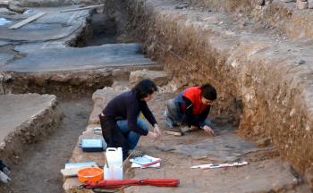 Narbonne - Au moment où l'architecte Norman Foster a été choisi pour la construction du futur musée de la Romanité pour un budget prévu de 40 millions d'euros, le plus beau site archéologique de la ville tombe en décrépitude, victime d'inertie et de manque de décision. Pourtant, chaque nouveau chantier sur Narbonne révèle son lot de découvertes. Comme celui en cours dans la rue Edmond-Valentin. Demain, les fouilles s'arrêteront et les vestiges de la riche demeure romaine seront recouverts pour laisser place au chantier. Le site du Clos de la Lombarde est le seul encore visible. Il a révélé de riches maisons patriciennes, des thermes, des ateliers artisanaux. Le site a livré de riches pavements et de somptueuses peintures murales qui représentent le plus bel ensemble de peintures antiques de la Gaule. Déposées au musée archéologique de Narbonne, elles en constituent aujourd'hui le joyau. Et pourtant, rien n'est fait ni pour la sauvegarde ni pour la valorisation touristique du Clos de la Lombarde, classé au titre des Monuments historiques. En 1991, l'État a concédé à la ville de Narbonne un bail emphytéotique jusqu'en 2079. Les actions de protection ou de valorisation du site relèvent donc de la compétence de la ville au titre de la valorisation de son patrimoine.
http://www.ladepeche.fr/article/2012/01/26/1270276-la-fille-de-rome-est-en-danger.html