
27 JANVIER 2023 NEWS
INSTITUT SUPERIEUR D'ANTHROPOLOGIE
INSTITUTE OF ANTHROPOLOGY
ONLINE COURSES / COURS A DISTANCE
DEBUT COURS : FEVRIER 2023
REGISTER NOW
JAPON –  Nara - The largest bronze mirror and largest "dako" iron sword in Japan were discovered from a late-fourth century tomb mound in the western city of Nara, its board of education and an archeological institute that supported the excavation said Wednesday. The twin findings from the Tomio Maruyama Tumulus last November can be classified as national treasures, experts say, with the discovery of the shield-shaped mirror being the first of its kind. The 2.3-meter sword with a meandering blade is also the largest iron sword made in that period in East Asia. "(These discoveries) indicate that the technology of the Kofun period (300-710 AD) are beyond what had been imagined, and they are masterpieces in metalwork from that period," said Kosaku Okabayashi. He called their discoveries a breakthrough in the research of the period, named for the "kofun" tomb mounds built for members of the ruling class. The 2.3-meter sword with a meandering blade is also the largest iron sword made in that period in East Asia."(These discoveries) indicate that the technology of the Kofun period (300-710 AD) are beyond what had been imagined, and they are masterpieces in metalwork from that period," said Kosaku Okabayashi, the deputy director for Nara Prefecture's Archaeological Institute of Kashihara. He called their discoveries a breakthrough in the research of the period, named for the "kofun" tomb mounds built for members of the ruling class. The patterned surface of the mirror carries the designs of two more common "daryu" mirrors, distinctive with its designs based on imaginative creatures, which have been found mainly in western Japan. The shield-shaped mirror is 64 cm in length, 31 cm in width at most, and weighs 5.7 kilograms. The sword is the oldest of dako swords distinguished by their wavy, snake-like shapes, from which their name is derived. The latest sword has markings of a sheath and handle, and together, its length measures 2.6 meters, more than dominating the last longest dako sword discovered at around 85 cm. Mirror and shields are considered to be tools to protect the dead from evil spirits. The sword is thought to have been enlarged to increase its power, and the possibility of its use as a battle tool is low.The Tomio Maruyama burial mound, the largest in Japan at 109 m in diameter and dating back to the late 4th century, is thought to have belonged to a powerful individual supporting the Yamato rulers of the time.
https://mainichi.jp/english/articles/20230126/p2g/00m/0na/004000c
GRECE – Santorin - Kolumbo, an underwater volcano off the Greek island of Santorini, has been quiet for over 400 years, but it is not sleeping. The steady filling of a previously unknown magma chamber with melt has prompted geologists to urge real-time monitoring of the volcano. The last time Kolumbo erupted, in 1650, it killed 70 people. Kolumbo is a member of the very explosive volcano family, capable of creating an eruption column tens of kilometers high, as per The Guardian. It also has the potential to cause a tsunami, making it a very frightening scenario. A major volcanic explosion, possibly the greatest ever observed by humans, occurred in 1646 BC at Thera (present-day Santorini), an Aegean island near Crete. The explosion, which was believed to be the equivalent of 40 atomic bombs or nearly 100 times more powerful than the Pompeii eruption, ripped out the interior of the island and permanently changed its topology. As a result of the volcanic eruption, up to 20,000 people may have died. Akrotiri, a village on Thera, was buried in a thick blanket of ash and pumice, just as Pompeii was centuries later. The old Bronze Age village was buried for more than 3,500 years, one of Greece's numerous historical secrets. Spyridon Marinatos, with the assistance of the Archaeological Society of Athens, soon began excavating the ruins of the old town. The subterranean houses were not only two or three stories tall, but the original building materials (clay and wood) had been ruined by earthquakes, fire, and the passage of time.
ANGLETERRE –
 Eastbridge - Part of an "exceptionally rare" Iron Age wooden axle from a chariot or cart has been found in a waterlogged pit. Recent analysis revealed the hazel wood axle was made between 400BC and 100BC. The dig unearthed two Iron Age pits, which experts believe were most likely used as watering holes for livestock. The base of the axle had been broken, burned and reused and was found with charred boards, which might also have come from the same chariot. Mr Fern said: "Most of the spindle - for the wheel hub - survives, as well as part of the rectangular axle-bed which would have been secured to the underside of the cart or chariot."
https://www.bbc.com/news/uk-england-suffolk-64401388
MEXIQUE – 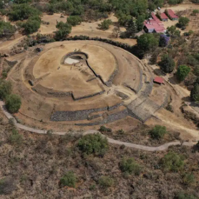
 Cuicuilco - The city emerged during a period when Mesoamerican villages from the mid-Preclassic (800 BC) were merging into the large population centres of the late Preclassic (AD 100). The city became an important regional urban and ceremonial centre comparable with Teōtīhuacān, inhabited by an estimated population of around 20,000 people that had an agricultural economy based on farming the fertile land in the surrounding lagoon basin of the Mexico Valley.The people practiced cranial deformation using circular wraps with rigid compression devices, resulting in rounded heads or oblique tubular features that show similar characteristics of Olmecoid head portraiture, suggesting the possible interacting with the Olmec of the Gulf Coast of lowland Veracruz and Tabasco (also known as the Olmec heartland). Excavations at Cuicuilco have revealed several small platform structures, houses, and plazas which are estimated to have covered an area of 1,000 acres, centred on a large truncated cone pyramidal structure.The pyramid, which is an early form of the large temple pyramids that would dominate Mesoamerican sites as Teōtīhuacān, the great Maya cities, and the Aztec capital Tenochtitlan, was constructed during the 5th century BC, and was built with a stone core covered with sun-dried brick and a volcanic stone facing. On the pyramid’s summit was a stone altar that shows traces of a red pigment (cinnarbar), suggesting that the people of Cuicuilco practiced ritual sacrifice during religious ceremonies. A series of eruptions at the Xitle volcano during the end of the pre-Classic period released basaltic lava flows that engulfed much of the city in volcanic rock, leading to the dispersion of Cuicuilca’s people towards Toluca and Teōtīhuacān. Teōtīhuacān hosted a large part of the Cuicuilcas and incorporated many features of their culture, giving rise to Teōtīhuacān as the centre of the Basin of Mexico for the next 500 years.
https://www.heritagedaily.com/2021/08/cuicuilco-the-mesoamerican-city-destroyed-by-a-volcano/139951
EGYPTE – 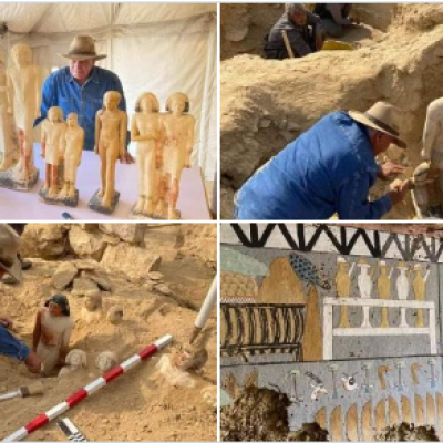 Saqqara - Archaeologists have announced the discovery of four 4,300-year-old tombs and a mummy wrapped in gold leaf. The mummy is made up of the remains of a man named Hekashepes and found preserved inside of a sarcophagus. It is one of the oldest and most complete non-royal corpses that has ever been discovered in Egypt. It was discovered in a burial site at Saqqara, which is located 19 miles south of Cairo, down a 15-meter-long (Approx. 50-foot-long) shaft, together with four other tombs.One of the tombs belonged to a person known as the “secret keeper.” It is believed that the person known as Khnumdjedef, who served as a priest, inspector, and supervisor of nobles, was the owner of the largest of the mummies that were discovered at the ancient necropolis. Another belonged to a man named Meri, who held the position of senior palace official and had been granted the title of “secret keeper,” which gave him the authority to carry out particular religious rituals. A judge and writer by the name of Fetek was laid to rest in the other tomb, which was discovered with a collection of statues that are regarded to be the biggest to have been unearthed in the region. A fourth tomb belonged to a priest at the pyramid complex of king Pepi I, which also contained nine beautiful statues. Among the tombs, archaeologists have discovered a number of other items such as amulets, deity statues, stone vessels, pottery and daily life’s tools. Archaeologist Zahi Hawass, who has also served as Egypt’s minister of antiquities, stated that all of the findings were made between 2686-2181 BCE, during the Fifth and Sixth dynasties of the Old Kingdom.
https://greekreporter.com/2023/01/27/archaeologists-discover-4300-year-old-tombs-golf-leaf-mummy/
CHINE –  Nanyang - Scattered across the hills of China, numerous rock paintings have been rediscovered. The meticulously crafted designs have become cryptic messages from millennia ago. Archaeologists in Nanyang have identified several more petroglyphs, or ancient rock paintings, with a variety of designs, the Institute of Archaeology at the Chinese Academy of Social Sciences said in a Friday, Jan. 6, news release via China News Network. The petroglyphs were hammered into granite and quartz sandstone, researchers said. Photos show the rock paintings with two distinct design styles: a linear carving style and a dotted carving style. Rock paintings are common across Nanyang and tens of thousands of petroglyphs have been identified, according to the release. The diverse petroglyphs are all considered part of the Central Plains rock painting system. Petroglyphs in Nanyang were carved from the Neolithic Age to the Bronze Age, according to a 2012 study by Tang Huisheng published in the Rock Art Research journal. The paintings are anywhere from 6,000 years old to 11,000 years old. Researchers have speculated that the petroglyphs may be part of an early human writing system, a sort of astronomical calendar or an expression of ancient human ideology, per the news release.
https://www.ledger-enquirer.com/news/nation-world/world/article271705027.html
ITALIE -  Rome - It’s a question that has long eluded an answer: where exactly was the beginning of the Appian Way, the ancient Roman thoroughfare so famous that it was known as the “regina viarum,” or queen of roads. Remains of the original Appian Way, named for Appius Claudius, a Roman consul, and begun in 312 B.C., are still visible (and make for a great walk) within Rome. But traces of the so-called first mile remain buried some eight meters, or 26 feet, below the street level of contemporary Rome. Last July, a team of archaeologists began a hunt for the lost starting point of the Via Appia by excavating a site in front of a row of ancient shops — still visible — that were once part of the monumental entrance to the thermal baths that the Emperor Caracalla built in A.D. 211. Digging down through Rome’s millenary history, archaeologists and historians collected plenty of information and data to crunch. They found traces of the farmland and vineyards that occupied this area for more than 1,000 years, until Rome rapidly modernized and expanded after it was named capital of Italy in 1870. And they unearthed the remains of a 10th-century road, and even older buildings, finds that suggest that from the sixth century A.D. through the high Middle Ages, this was a busy district. Archaeologists think the structures might have been shops serving pilgrims who stopped in the Christian sites that are believed to have sprung up in the area in that time. Ancient sources report that in the vicinity, Septimius Severus, who was emperor from 193 to 211, had a broader thoroughfare — 100 Roman feet wide — built to accommodate the growing Roman population. Known as the Via Nova, the road is marked in the Forma Urbis Romae, the great third-century marble map of Rome. Debate continues among archaeologists over the interconnection between the Via Nova and the Via Appian — whether they were side by side, whether the Nova was placed directly above the older road, or whether Septimius merely widened the Appia to create the Nova. The walls of the shops found in the current excavation stand about 30 meters — or 100 Roman feet — from the still-visible shops in front of the Baths of Caracalla, meaning that the road that passed in between would correspond with the exact width of the Via Nova. So there are compelling signs that a road existed where the digging took place, “but we still can’t say whether this was or wasn’t the Appian Way,” Ms. Serlorenzi said. New excavations will depend on whether funding can be found. Artifacts unearthed during the excavation point to many centuries of occupancy, including pottery dating to various epochs, a marble head of a boy dating to the third century, tiny Roman-era bronze coins that archaeologists described as “spare change for minor expenses” and a more precious square coin minted between 690 and 730, at the time that papal power was rising in Rome.
https://www.nytimes.com/2023/01/26/world/europe/roman-road-appian-way-beginning-italy.html