ARCHEOLOG-HOME / INDIana-UNIversitas
Contact


21 OCTOBRE 2011 NEWS
21 OCTOBRE
INDI-UNI : ANTHROPOLOGY - ARCHAEOLOGY
INSCRIPTION 2011 – 2012 COURS A DISTANCE
REGISTRATION 2011 – 2012 ONLINE COURSES
CANADA – 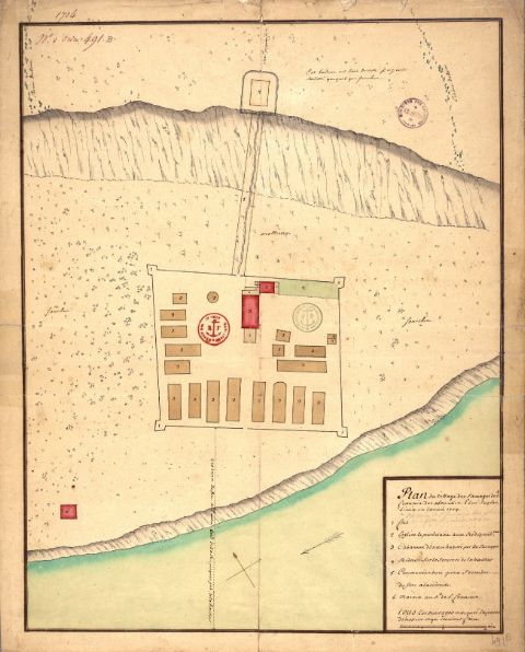 Odanak - Poursuite des fouilles visant à retracer le Fort d'Odanak. Rappelons que celui-ci à été construit en 1704 aux abords de la rivière St-François et qu'il s'agissait de la seule fortification commandée par le roi de France construite par un contingent militaire français et Abénakis, puis habitée par une population autochtone. «Les recherches en vue de retracer le Fort d'Odanak permettront de documenter plus précisément les modes de vie du passé et de répondre à des questions pointues telles que la reconstitution des techniques artisanales, de la diète alimentaire et du tissu végétal notamment en ce qui concerne les plantes médicinales afin d’encourager un programme de réintroduction de la flore disparue», laisse entendre Mme Bélanger. «Nous avons réalisé que notre passé n'était pas si profond sous nos pieds. C'est incroyable et très important pour la nation abénakise», rajoute Rick O'Bomsawin,chef du Conseil de bande d'Odanak. Malgré l'arrivée de la saison automnale, des sondages archéologiques se poursuivent depuis le 11 octobre sur les terrains adjacents au Musée. «En août, nous avons eu sept sondages positifs qui démontraient une occupation continue du lieu. Les nouveaux sondages nous permettent de voir ce que nous n'avions pas pu observer jusqu'à maintenant. Jusqu'à présent nous avons découvert un trou de poteau, des marques d'incendie dans le sol et plusieurs objets qui correspondent au 17e siècle. Toutefois, ça ne veut pas dire que nous avons trouvé le Fort», raconte Geneviève Treyvaud. «On parle d'une possibilité d'occupation jusqu'à 8000 ans avant Jésus-Christ. Il y a une possibilité de trouver des vestiges très très anciens et des plus récents qui sont associés au Fort», soutient Michel Plourde.
http://www.lecourriersud.com/Culture/2011-10-19/article-2781094/Sur-les-traces-du-Fort-dOdanak/1
CHINE – Erdos - Archaeologists have unearthed thousands of stone implements dating back about 40,000 to 70,000 years in north China's Inner Mongolia Autonomous Region, sources said Thursday. Archaeologists from the Chinese Academy of Sciences and the Erdos Bronzeware Museum started excavating an area in the basin of the Ulan Mulun River in April, discovering more than 4,200 stone implements, including stone flakes, saw-shaped tools and remnant stones, according to Hou Yamei, the leader of the excavation team. The river is a seasonal river near the city of Erdos and is believed to have been a primary location for stone tool production in ancient times, Hou said. The large number of relics uncovered near the river proves that the region was a main living area for people living during the Stone Age, Hou said. About 3,400 animal fossils have also been discovered in the area, with experts concluding that the animals lived in nearby grasslands. The discovery of the tools and subsequent research will help to shed light on the study of Stone Age culture, Hou said.
http://www.kaogu.cn/en/detail.asp?ProductID=3113
CHINE – 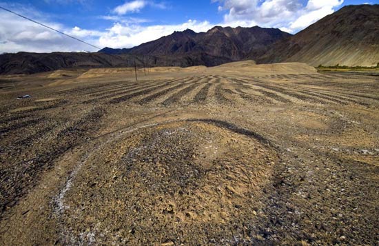
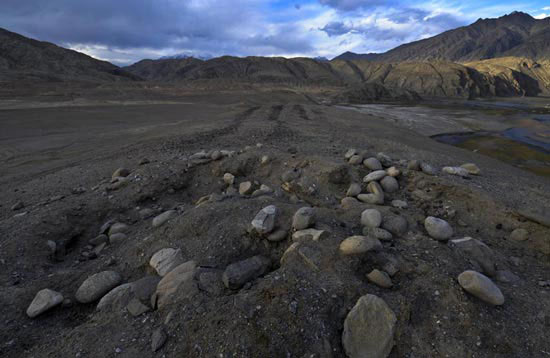 – Xinjiang - Recently archaeologists from Xinjiang archaeological team of Archaeological Institute, subordinated to Chinese Academy of Social Sciences, recently discovered a strange tomb formed by black and white stones in a flatland near the Tashikuergan River in Xinjiang province. Fist-sized black and white stones are alternatively lying on the 100-meter by 50-meter flatland. On the western side of the flat, there is a circular tomb with a diameter of 2 meters. At sunset, the smooth and round black stones and the angular white stones reflect the sunlight, which presents a solemn appearance. Wu Xinhua, captain of the archaeological team, said that it was the first time to discover a tomb of this kind. No similar tombs were ever discovered in Pamirs, the Qinghai-Tibet plateau or Central Asia.
http://www.kaogu.cn/en/detail.asp?ProductID=3114
FRANCE – Brive - Deux mois et demi de fouilles prennent fin aujourd'hui. Des explorations qui auront permis d'en apprendre un peu plus sur la configuration du peuplement sur le bassin à la période charnière de la romanisation des Gaules entre leur conquête par César en -52 et le IIe siècle après J.-C. Contrairement à ce qui avait pu être annoncé, l'antériorité de l'installation briviste et du pont orienté nord-sud auquel la cité doit son nom, estimée au Ier siècle après J.-C, n'est pas remise en cause par ces découvertes. Néanmoins, ces vestiges, datés du IIe siècle après J.-C, témoignent déjà à l'époque d'une extension conséquente de la commune vers l'est sur un axe commercial moins connu. Pour les archéologues, en effet, les agglomérations sont trop rapprochées pour pouvoir être distinctes. Néanmoins l'ampleur de cette extension antique de la cité étonne. « L'existence de sites protohistoriques gaulois du IIe siècle avant notre ère à proximité du lieu de fouille, en bord de Couze, laisse penser que les implantations de types gallo-romaines sont venues s'ajouter à des villages préexistants », poursuit la responsable. La présence de puits, à côté de chaque bâtisse semble en outre indiquer qu'il s'agissait d'un quartier à vocation artisanale, même si l'arasement des bâtiments ne permet pas de s'assurer de l'existence de fours nécessaires à de telles activités. Par ailleurs, la présence d'un mur d'enceinte, trop faible pour avoir un rôle défensif et comprenant un point de passage, évoque la possibilité d'une frontière douanière à l'entrée du bassin briviste. « C'est une chance que d'avoir eu accès à ces terres agricoles, pour ainsi dire vierges, sur une surface conséquente (4,5 ha). Ailleurs, sur Brive notamment, la superposition des époques de construction, rend ce type de fouilles plus délicat ». Selon les premières hypothèses, le site aurait tout bonnement été abandonné à l'aube du IIIe siècle après J.-C, entre haut et bas empire, suite à un mouvement de reconcentration des cités en réaction aux menaces barbares commençant à peser sur le monde gallo-romain. Sur la dizaine de puits répertoriés sur le site, qui constituent du fait des propriétés de l'eau, des lieux de conservation privilégiés, un seul a été sondé, duquel ont pu être extraits une vingtaine de cruches, vases et autres petits objets du quotidien : bouts de verre, tablette d'écriture. Des prélèvements géologiques ont également été réalisés pour la datation et l'analyse de l'activité locale. Reste désormais aux recherches en laboratoire de confirmer ou d'infirmer ces hypothèses en les précisant.
ROYAUME UNI –  Dingwall - New archaeological findings which indicate a Dingwall town centre car park was once the site of a Viking law court or assembly has been described as a "significant development" which could open up major tourism opportunities for the town. An archaeological radar survey of Cromartie Car Park behind the High Street and the discovery of medieval records has revealed that it is probably the location of a Viking mound - the first one in mainland Scotland to be identified. Experts are convinced the name Dingwall derives from two ancient Norse words ?ing and v?llr, which taken together mean "field of the assembly", as in a legal gathering or law court. Exactly where Dingwall's Viking law court actually met has long eluded archaeologists. The site in question appears to have centred on a large earth mound that was located just north of the High Street beside the town's old parish church. Now covered in tarmac, the mound has served as a car park since 1947 and prior to this had been adapted as a burial memorial to the Earl of Cromarty in the early 18th century. This tall stone obelisk still forms an imposing landmark. The car park was closed-off to public, allowing Dr O'Grady and a team of local volunteers to carry out a detailed Ground Penetrating Radar survey. Arriving at the same conclusion, that Dingwall's Viking court-mound or 'thing' was beneath the town's Cromartie Memorial Car Park, O'Grady and MacDonald are now collaborating to bring Dingwall's Viking heritage out of obscurity. "The radar results have been very informative. It looks like we've discovered a very large in-filled ditch around the north side of the mound", said Dr O'Grady. "Radar is a powerful technique. Archaeologists are now at a point where we can examine layers of deposits, buried at depth, without even having begun to dig, even beneath tarmac". Dr O'Grady suggested the ditch may have been formed during quarrying to create the mound. It is thought the ditch may have also acted as an enclosure around the site, perhaps used to "fence" Viking courts held on the mound. However, the archaeologist stressed the survey results will now require verification by excavation.
http://www.ross-shirejournal.co.uk/News/Car-park-was-court-of-law-for-Vikings-7305257.htm