
20 MARS 2023 NEWS
INSTITUT SUPERIEUR D'ANTHROPOLOGIE
INSTITUTE OF ANTHROPOLOGY
ONLINE COURSES / COURS A DISTANCE
DEBUT COURS : AVRIL 2023
REGISTER NOW
USA –  James Fort - The Zuñiga Map is a manuscript depicting the Chesapeake Bay and Tidewater Virginia, which is a copy of a map probably drawn by Captain John Smith, who played an important role in the establishment of the colony at Jamestown. The map is named after Don Pedro de Zúñiga, a Spanish ambassador to England who sent the map to Philip III of Spain in 1608. The map is significant for noting the location of native villages, the location of Jamestown, and the architecture of James Fort, which is used in the logo for the Jamestown Rediscovery Project. A closer examination of the map shows a feature that looks like a flag extending from the north bulwark of the fort, which has led to new excavations on a previously unexplored area of Jamestown Island. According to former Jamestown curator, Bly Straube, the flag may have been incorrectly interpreted and could indicate an enclosure or garden that supported the fort inhabitants. Back in 2019, researchers from the Jamestown Rediscovery Project conducted a ground penetrating radar (GPR) survey on the area indicated by the flag. The survey revealed a large ditch that archaeologists believe dates to 1608. Excavations in 2022 found a Confederate moat from 1861 which cut into the ditch, in addition to a brick-lined well from 1617 north of what was once Fort Pocahontas. Fort Pocahontas was a Civil War-era Confederate fort that was built on top of James Fort shortly after Confederate troops arrived at the island in 1861. Excavations are planned in the autumn of 2023 to reveal the entirety of the well and further investigate the area indicated by the flag feature on the Zuñiga Map. John Smith wrote of more than 50 houses at Jamestown in 1608, and archaeologists have yet to uncover any of these houses in the vicinity of the fort.
EUROPE –  Nord - Bog body studies have focused on rich individual biographies, largely neglecting broader spatial and temporal trends. Here, the authors present the first large-scale overview of well-dated human remains from northern European mires, based on a database of 266 sites and more than 1000 bog mummies, bog skeletons and disarticulated/partial skeletal remains. Analysis demonstrates fluctuating depositions of human remains between the Early Neolithic and early modern times, significant and shifting spatial clustering, and variation in site characteristics (e.g. preservation, use frequency, cause of death). The results emphasise previously unrecognised activity phases and highlight issues with categorising motives, especially around ritual violence.
NORVEGE –  Gjellestad - When news broke in 2018 that another Viking-Age ship burial had been found on the shores of the Oslo Fjord, it quickly became one of the finds of the century. Compared to its truly legendary predecessors of the Gokstad and Oseburg ships, the newly-found Gjellestad ship is not going to be mounted in a museum any time soon; most of the woods has disintegrated. That hasn’t stopped Norwegian archaeologists from figuring out a lot about what was going on from the time of the burial and the ship. Excavations began in 2020 and concluded in October of 2021. Early on it was clear that nothing like a ship could be removed from the earth, not only for the condition of the wood, but also the rivets. More than 1,300 of them lined the clinker-built hull, but the iron flaked away at the slightest disturbance, requiring the excavators to remove them in blocks of dirt for CT scans. However, at the bottom of a central trench, the team found the ship’s keel, which is the beam of wood that sits underwater along the central spine of the ship. Viking Age boats are famous for having a shallow draft, in part because of their small keels. This allowed them not only to go to sea, but sail up shallow rivers as well. Tree-ring analysis and carbon dating showed the wood for the keel was felled in the 700s, meaning the ship probably saw action between the late 8th century to the 10th century—primetime for Vikings in that part of the world.The rivets could contain vital clues just as wood residue and other evidence of how it was built and with what materials. “The area was thus a well-established burial ground when the Gjellestad ship and the person, or persons on board, were buried here,” writes Mari Wammer at the Museum of the Viking Age, Univ. of Oslo. “It has probably been a sacred place, which has evolved from a classic Iron Age society with settlement and burial mounds side by side, to becoming a burial ground only.” The latter is likely the truth, because in a summary of their findings reported on by National Geographic, the archaeologists determined through soil samples that tomb robbers entered the mound around the year 950 CE by tunneling underneath the soil and cutting a hole through the hull to get at the loot inside, where they also may have exposed the remains of whoever was buried inside to oxygen. Ship burials were the ultimate expression of power, and the ceremony of internment would have gone on for days and involved for days, while the grave itself continued as a center of communion with the dead.
CHINE –  Luoyang - A defensive trench dating back around 6,000 years has been discovered at a relics site in central China's Henan Province, according to the municipal institute of archaeology of Luoyang City. This was reported by The Xinhua News Agency. "The semi-annular trench, located at the Suyang relics site in Yiyang County, was dug manually, and the shape and structure reflected the powerful and orderly social organization ability and technical level at that time", – said Ren Guang, who is in charge of the excavation of the site. Based on unearthed relics and the accumulated layers in the trench, archaeologists believe that the trench had gone through three periods of the Yangshao Culture, dating back 5,000 to 7,000 years. "By the late period of the Yangshao Culture, the trench had probably lost its defensive function, as a number of house sites, ash pits, and production and household relics from this period were found on both sides of the trench", – Ren said. "Rows of wooden posts that may have been used to protect the trench reflected the re-use of the abandoned facility by people at that time", – Ren added. Pottery, stone, jade, bone and mussel wares were also found at the site, as well as a few well-preserved remains of carbonized corn and millet. Archaeologists initiated the Suyang relics site excavation work in early 2021.
https://ukranews.com/en/news/918762-6-000-year-old-defensive-trench-unearthed-in-china-s-henan
EGYPTE –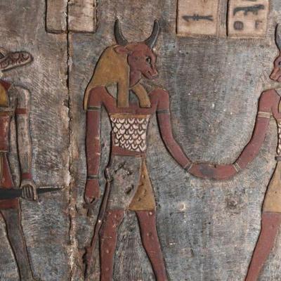
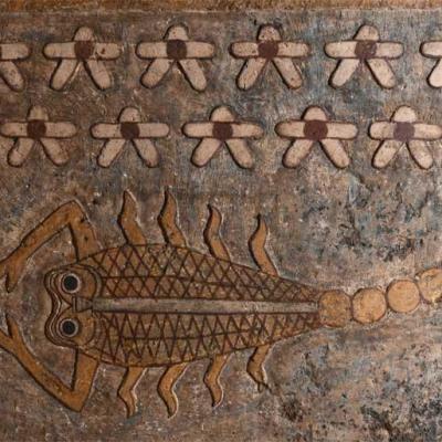
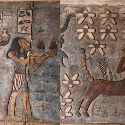
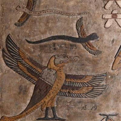 Esna - Egypt’s first complete Zodiac was uncovered on the ceiling of the Temple of Esna in Luxor governorate during restoration work carried out by an Egyptian-German expedition. After five years of cleaning and restoration work, the joint Egyptian-German mission uncovered a bright and colourful astronomical representation of the ancient Egyptian night sky. The relief contains all the twelve Zodiac signs, the outer planets of Jupiter, Saturn and Mars, as well as depictions of the so-called seven arrows and constellations used by the ancient Egyptians in time measurement. Dr Mostafa Waziri, Secretary General of the Supreme Council of Antiquities, said the colourful reliefs also depicted deities, animals, names of divine figures and composite beings, including a ram-headed serpent and a crocodile-headed bird. The Temple of Esna dates back to the Roman period. Construction began under the reign of Emperor Claudius while its decorations were finished during the time of Emperor Decius, between 249-251 AD. The temple is dedicated to the ram-headed god Khnum and his divine consorts.
PEROU – 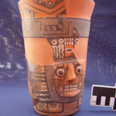 Wari - Researchers led by M. Elizabeth Grávalos and Patrick Ryan Williams analyzed the chemical makeup of ceramics unearthed at different sites in the Wari Empire, which covered more than 1,000 miles over the Andes Mountains and the coast of Peru from A.D. 600 to 1000. The scientists wanted to determine if areas colonized by the Wari Empire imported ceramics from the Wari capital, or if the local potters continued to produce their own wares. The results of the study suggest that in some areas of the empire, Wari colonists had their own production centers and recreated traditional Wari-style pottery in new locations. In other areas, local potters made Wari-style pottery in their own way, blending Wari style with local traditions. “Local production, even in a cosmopolitan society with lots of far-flung connections, makes a society more resilient,” Williams said. “If you’re entirely dependent on someone far away sending you things you need, you’re extremely vulnerable,” he concluded.
GALLES -  - Holyhead Mountain - The well-preserved ruins of a prehistoric farming community give a fascinating look into the history of agriculture in North Wales. The Holyhead Mountain Hut Circles are the remains of an Iron Age farmstead in South Stack, Anglesey. Also known as the Tŷ Mawr Hut Circles, the Cadw-preserved site is located at the southwestern end of Holyhead Mountain, within the RSPB nature reserve. The discovery of Roman artefacts initially led archaeologists to believe the huts were from the Roman period, but the site is thought to date back much earlier, to the Iron Age.At one time, the mountainside is said to have housed more than 50 huts, which were used by some of Wales' first farmers. Today, around 20 of the huts remain visible, painting a picture of the circular homesteads which at one point occupied the mountain. The circular huts would originally have had a conical roof, supported by poles. Some of the buildings were more oval shaped with dividing internal walls, and others were used as workshops for farm work.
https://www.dailypost.co.uk/news/north-wales-news/gallery/mountain-hut-circles-built-north-26504227
UAE - 
 Siniyah Island- Archaeologists said Monday they have found the oldest pearling town in the Persian Gulf on an island off one of the northern sheikhdoms of the United Arab Emirates. Artifacts found in this town on Siniyah Island in Umm al-Quwain, likely once home to thousands of people and hundreds of homes, date as far back as the region's pre-Islamic history in the late 6th century. While older pearling towns have been mentioned in historical texts, this represents the first time archaeologists say they have physically found one from this ancient era across the nations of the Persian Gulf. "This is the oldest example of that kind of very specifically Khaleeji pearling town," said Timothy Power, an associate professor of archaeology at the United Arab Emirates University, using a word that means "Gulf" in Arabic. "It´s the spiritual ancestor of towns like Dubai." The pearling town sits on Siniyah Island, which shields the Khor al-Beida marshlands in Umm al-Quwain, an emirate some 50 kilometers (30 miles) northeast of Dubai along the coast of the Persian Gulf. The island, whose name means "flashing lights" likely due to the effect of the white-hot sun overhead, already has seen archaeologists discover an ancient Christian monastery dating back as many as 1,400 years. The town sits directly south of that monastery on one of the curling fingers of the island and stretches across some 12 hectares (143,500 square yards). There, archaeologists found a variety of homes made of beach rock and lime mortar, ranging from cramped quarters to more sprawling homes with courtyards, suggesting a social stratification, Power said. The site also bears signs of year-round habitation, unlike other pearling operations run in seasonal spots in the region. "The houses are crammed in there, cheek by jowl," he added. "The key thing there is permanence. People are living there all year around." In the homes, archaeologists have discovered loose pearls and diving weights, which the free divers used to quickly drop down to the seabed while relying only on their held breath. The town predates the rise of Islam across the Arabian Peninsula, making its residents likely Christians. Islam´s Prophet Muhammad was born around 570 and died in 632 after conquering Mecca in present-day Saudi Arabia.
https://www.dailymail.co.uk/wires/ap/article-11880435/Their-world-oyster-Oldest-pearl-town-UAE.html
ISRAEL – 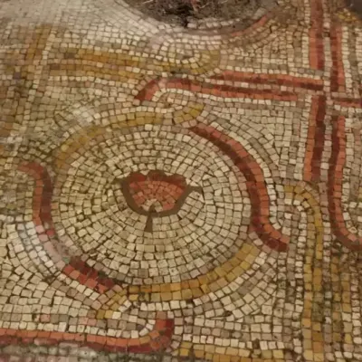 Shoham - An ancient mosaic floor was uncovered along the Israel National Trail 40 years after it was first discovered, the Israel Antiquities Authority reported on Sunday. The location where the mosaic was uncovered is in the industrial zone of Shoham. The mosaic, which had been part of a church floor, was part of a church that most likely dated back to the Roman era. The design shows colorful sections with flower designs in them that are likely inspired by anemones that flower in the area.
https://www.jpost.com/archaeology/article-734789
FRANCE – Chauvet - Pont d'Arc - Une vingtaine de vestiges osseux sont attribuables à des grands canidés. Ont-ils fréquenté la grotte en même temps que les hommes ? Nous avons posé la question à Nicolas LATEUR, archéologue paléontologue au service archéologique départemental de l’Ardèche et chercheur au CNRS.
FRANCE –  Grotte de Cro-Magnon - Discovered over 150 years ago, the early Upper Paleolithic human remains from the Cro-Magnon rock shelter have an iconic status, but because of skeletal commingling after discovery, their bio-profiles remain incomplete and contentious. The defect on the frontal bone of the cranium known as Cro-Magnon 2 has been interpreted as both an antemortem injury and a postmortem (i.e., taphonomic) artifact previously. This contribution considers the cranium in order to clarify the status of the defect on the frontal bone and to situate these remains among others of Pleistocene date with similar types of lesions. The diagnostic criteria used to assess the cranium are drawn from recent publications of actualistic experimental studies of cranial trauma and from those associated with cranial trauma due to violence in forensic anthropological and bioarchaeological contexts. The appearance of the defect and comparison with more recent documented cases from the preantibiotic era suggest that the defect is a result of antemortem trauma with survival for a short period. The location of the lesion on the cranium provides growing evidence for interpersonal aggression in these early modern human groups, and the place of burial also provides insight into related mortuary behavior.
https://www.sciencedirect.com/science/article/abs/pii/S0047248423000064
FRANCE –
 Niort - Des fouilles archéologiques sont menées devant la mairie, dans le cadre de la rénovation de la place Martin-Bastard. Elles ont démarré début février et doivent se poursuivre jusqu'en août. Et il y a déjà des découvertes. Les latrines, autrement dit les toilettes, de l'ancien oratoire ont été découvertes. Cet oratoire a accueilli des prêtres séculiers à partir de 1617. Ils y ont fondé un collège pour les jeunes niortais. Et elles sont riches d'enseignements car à l'époque ces latrines servaient aussi de poubelles. Des latrines de quatre mètres de profondeur. Les premiers sondages ont révélé la présence de morceaux de céramique, de verre, d'ossements d'animaux... qui permettront d'en savoir plus sur la consommation et le mode de vie de ces moines oratoriens. "On a vu des vertèbres de poisson par exemple. Donc ces moines avaient les moyens d'accéder à une alimentation que toute la ville de Niort ne pouvait pas s'offrir", indique Jérôme Primault, conservateur du patrimoine à la DRAC la direction régionale des affaire culturelles Nouvelle-Aquitaine.