20 JANVIER 2015 NEWS: Hinkley Point - Shropshire - Tepeköy - Galway-Mayo - Chungju - Cerreto Vecchia -
INSTITUT SUPERIEUR D'ANTHROPOLOGIE
INSTITUTE OF ANTHROPOLOGY
ONLINE COURSES / COURS A DISTANCE
SPRING TERM : APRIL 2015
REGISTER NOW
ROYAUME UNI – 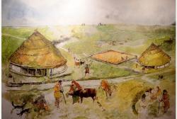 Hinkley Point - A Dark Age cemetery with 100 burials, is part of the remarkable history of Hinkley Point brought to light by excavations ahead of power station construction. It is part of the long history of the area revealed in an exciting exhibition opening at the Museum of Somerset this week.Finds include a Bronze Age enclosure, Iron Age and Roman farms alongside evidence of burials and cremations. The Dark Age cemetery, dating from around 500-750AD, has recently been found on the west side of the Hinkley Point site. Two other sites have been uncovered on the line of the Cannington by-pass site: a small Bronze Age settlement and Romano-British period building from around the third century AD. Evidence has been found of luxury goods being brought in from the Mediterranean to Roman Somerset, while scattered in fields are microlith flints, tiny tools made 10,000 years ago by hunters and gatherers. Most of the Dark Age burials are lying east-west, suggesting they are Christian. Excavation work will continue until spring and the skeletons will be researched, with respect and care.
http://www.westerndailypress.co.uk/Dark-Age-uncovered-Hinkley-site/story-25886663-detail/story.html
ROYAUME UNI – 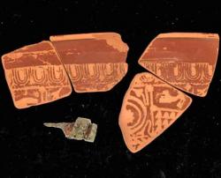 Shropshire - Archaeologists will deploy drones, millimetre-accurate laser scanning and dendrology on trees from nearly 600 years ago during a survey of 28 timber-framed buildings in a Shropshire hamlet which will be one of the largest medieval studies of its kind carried out in Britain.Basing their investigation on an estate map made in 1631, Dr George Nash, a Visiting Fellow at the University of Bristol, and Alastair Reid, of Tilley, in the north of the county, will tree-ring date timbers. Four samples taken from one of the buildings, Brook Farm, have been found to range from 1419 to a tree felled during the winter of 1579.“Based on place name evidence, the village of Tilley probably has its origins during the Early Medieval Anglo-Saxon period,” says Dr Nash, having been surprised at the age of the timbers from an initial study which was expected to find much later wood.
TURQUIE – 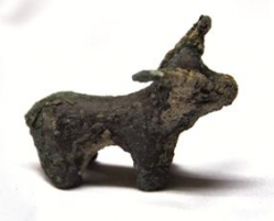 Tepeköy - A trade seal dating back to the Urartian era has been unearthed during archaeological excavations at the Tepeköy mound in the eastern province of Muş’s Varto district. Ahlat Museum Director Ziya Kılınç said 18 artifacts had been unearthed in the excavations that ended on Dec. 29, 2014. Among the artifacts was a stamp seal from the Urartian era, proving that the Urartians lived in the region during that era and carried out trade activities. “We have also found bull and human figures. We plan to display them at the Ahlat Museum after their mechanical cleaning. We plan to form a Muş-Varto corner with these artifacts,” said Kılınç. Kılınç said they were able to reach 2.5 meters deep in the excavations, but they were planning to dig 13 meters deep to find remnants from the Neolithic era. In addition to artifacts from the Assyrian era, the team also found artifacts from the Ottoman and Byzantine eras, such as cooking pots. Among the unearthed pieces are five pieces of a glass-made necklace. “Its rope has been decayed, but we have found five of the necklace pieces,” Kılınç said. “The artifacts can be completed, and they will be displayed in the museum. Our region is rich in terms of Urartian artifacts. They lived in tribes at first and then became a state. At the time of the king Sarduri, they turned into an empire. We believe we will discover very important artifacts, especially at depths of lower than three meters deep,” Kılınç said.
http://www.hurriyetdailynews.com/urartian-trade-seal-unearthed.aspx?pageID=238&nid=77141&NewsCatID=375
IRLANDE – 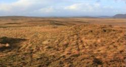 Galway-Mayo - Damage caused by Storm Rachel to fragile coastal heritage reinforces the need for a dedicated State archaeological “rescue” unit, according to north Connemara archaeologist Michael Gibbons who has recorded new finds on the Galway-Mayo uplands. The depression which hit the Atlantic coast last week coincided with neap tides, and did not have the same intensity as the early 2014 series of storm and tide surges, he notes. However, last week’s gales hit midden deposits near Dog’s Bay in Roundstone, exposing vulnerable dune areas to accelerated erosion, he says. He believes it emphasises the need for regional archaeology units, working with third-level institutions, to ensure inter-tidal evidence exposed by severe weather is recorded before it is lost to the elements altogether. Ancient waste The kitchen middens, or shell heaps, are ancient waste repositories which offer invaluable clues about the diet and lifestyle of our predecessors. Middens in and around Dog’s Bay include some of the earliest recorded by George Petrie in 1837 during his work for the Ordnance Survey, Gibbons points out. Separately, he has uncovered new evidence of booley settlements in the Partry and Maumturk mountain ranges where cattle were grazed in summer months. One isolated booley settlement in wild bogs to the south of Cleggan village, next to the townland of Buaile Árd – which translates as “high seasonal settlement” – is particularly interesting, he says, as it was used up until the late 1880s.
COREE DU SUD – Chungju- Archaeologists from the Jungwon Cultural Properties Institute found 19 pieces of bronze ware in a tomb in Chungju, North Chungcheong, that are believed to have been created between 2 BC and 1 BC and were probably used by a powerful ruler in the region. The archaeological exploration began in August and artifacts that included swords, a mirror, spears and an axe were found in a single tomb.
http://koreajoongangdaily.joins.com/news/article/Article.aspx?aid=2999840
ITALIE –  Cerreto Vecchia - A drone nicknamed Indiana Jones is being used to create a 3D map of a southern Italian city buried in a 1688 earthquake, termed a "medieval Pompeii". The drone uses laser impulses like a radar to provide information for relief sketches of the underground medieval city, Cerreto Vecchia, the city beneath Cerreto Sannita in the province of Benevento, about an hour's drive northeast of Pompeii. The project will take place in various stages, the first of which is the current 3D mapping. Once the mapping is complete, an archeological dig is planned, to be followed by restoration work, artifact cataloging, and a 3D reconstruction of the site.
http://www.ansa.it/english/news/lifestyle/arts/2015/01/16/drone-maps-out-medieval-pompeii_6be4b3dd-919b-40f3-b985-f43c6c03ddc6.html