1er JUIN 2023 NEWS
INSTITUT SUPERIEUR D'ANTHROPOLOGIE
INSTITUTE OF ANTHROPOLOGY
ONLINE COURSES / COURS A DISTANCE
DEBUT COURS : JUIN 2023
REGISTER NOW
ITALIE – 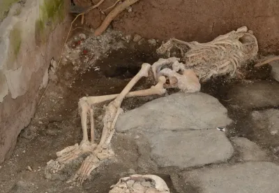 Pompéi - The remains of three people who perished in the eruption of Vesuvius in 79 CE have recently been unearthed during a recent dig in Pompeii. The skeletal remains are believed to have belonged to two women and a child aged around three or four who died while seeking shelter from the devastating eruption in a bakery. The recent discovery was announced by the Pompeii Archaeological Park on Monday. Along with the human remains, they also revealed that their ongoing excavations have uncovered a structure with two beautiful fresco walls: one depicting the sea god Poseidon and Amymone and another of Apollo and Daphne. Archaeologists on the project think the structure was likely a bakery with an oven, next door to a laundry used for washing and dying clothes. The finds were made in a commercial part of the town in an area called Regio IX. Excavations in this particular patch of Pompeii started in 1888, but were then put on ice for over a century.
EGYPTE – 
 -Giza - An analysis of bracelets owned by an Egyptian Queen has found that Egypt and Greece were involved in trade during the bronze age, much earlier than previously known. Queen Hetepheres was the mother of King Khufu, who would go on to build the Great Pyramid. Her tomb represents the largest and most famous collection of silver artefacts from early Egypt. While researchers have long known that the ancient Egyptians traded with other civilizations, the new study provides the first scientific evidence that silver was sourced from the Aegean Islands in Greece, researchers report today in the Journal of Archaeological Science. For thousands of years, her place of burial remained a mystery, until archaeologists came across a shaft in Giza in 1925 — where they found her empty sarcophagus. The researchers conjectured that Hetepheres had originally been buried near her husband’s pyramid in Dahshur, but her son ordered her tomb be moved to Giza after robbers broke in. While the whereabouts of her body and gold trappings remain unknown, a number of items were recovered from the tomb, including the bracelets. The team, which included researchers from France and the Museum of Fine Arts in Boston, where the bracelets are stored, scanned fragments to work out what they were made of. While the bracelets were last examined decades ago, Dr Sowada said they had never been analyzed “scientifically to a high degree.”The new analysis revealed the bracelets consist of silver with traces of copper, gold, lead and other elements. They were made by hammering cold-worked metal with frequent annealing — which involves heating it to a certain temperature to prevent breakage.While ancient Egypt was known to be rich in gold, it had no local sources of silver, Dr Sowada said.“So this period of early Egypt is a little bit terra incognita from the perspective of silver,” Dr Sowarda said, noting that the bracelets represented “essentially the only large-scale silver that exists for this period of the third millennium BC”. “Silver also has the added disadvantage of corroding more easily.” And it wasn’t until the early second millennium BC that “large quantities of silver” were preserved, she said.For a “very long time” researchers assumed the silver was extracted from local gold with a high silver content. But the new analysis of these bracelets has cast doubt on that theory, with lead isotope ratios in the silver from this time period found to be consistent with ores from the Cyclades Islands in the Aegean, and to a lesser extent, Lavrion (Attica in Greece). “So these bracelets represent a very, very unique opportunity to understand not just the metalworking techniques at this time, but also the trade networks that were existing, which are very important to understanding the emergence of Egyptian state,” Dr Sowada said. While lead isotope analysis has been done on other silver objects from the Middle Kingdom — with artefacts stored in the Metropolitan Museum of Art in New York also believed to have come from mainland Greece — we “just haven’t had that scientific evidence before” to show that Egypt was active in the Mediterranean region prior to that, Dr Pitkin, said.
https://greekreporter.com/2023/05/30/bronze-age-trade-egypt-greece/
IRLANDE –  Burren lowlands - An ancient fortress believed to be thousands of years old has been discovered in the ground under a popular play park. Archaeologist Michael Gibbons discovered the bronze age building whilst carrying out field work in the Burren lowlands of County Galway in Ireland.Measuring around 440 acres, the fortress is bounded on all sides by turloughs - a type of seasonal lake found only in Ireland near the River Shannon. When filled with water the turloughs would have made it almost impenetrable to enemy forces looking to storm the structure. Incredibly, it is believed to have been built around 3,200 years ago in what is now Coole Park. The site at Coole Park has been known but its origins and age were not understood until the recent studies Gibbons had been using sophisticated LiDAR equipment when he made the discovery the fortress was likely to have been built between 800 and 1200 BCE . He said: “We know there were numerous roundhouses within it, that they’re metalworking, and that they’re making high status artefacts.” The size of the building suggests it could have housed hundreds of people.
https://www.mirror.co.uk/news/world-news/ancient-fortress-hidden-trees-found-30106981
ANGLETERRE –  Weirs Beach - An archaeology team from Dartmouth College found thousands of artifacts and artifact fragments recently at Weirs Beach, ranging from nails and glass of the 19th century to arrowheads dating back as far as 8,000 years. In December, the same team underwent what was likely the area’s first archaeological radar survey to scan for potential sites. Now that snow has long departed and the ground thawed, the crew returned to conduct a small but fascinating dig into the past. Post-doctoral fellow Nathaniel Kitchell said he was hoping to find items from as far back as 10,000 to 12,000 years but still called the dig a “learning experience.” “In 1976, when the University of New Hampshire was out here previously, they located some areas that had human occupations going back at least 10,000 years, which is right after the end of the last Ice Age, which is a period of profound environmental and social change in this region,” Kitchell said. “The goal of this is to try to relocate some of those areas and gain a better understanding of what was going on and better contextualize the findings that had already been made in 1976 and to get a new radiocarbon date. We have better technology, so now we can do a little bit better.” The 8,000-year-old arrowhead mentioned before was part of the Neville variant, defined by sharp notches at the base. “This is a very unique projectile point of the region,” explained doctoral student Jonathan Alperstein. “These have this kind of almost 90-degree and very narrow aspect to it.” Moving 1,000 years forward, Alperstein displayed a “stark” point arrowhead that featured a less prominent point.On Wednesday, the team had yet to reach the mythical 10,000-year-old layer, and time was running out.
ANGLETERRE -  Salisbury – Archaeologists have uncovered a giant Bronze Age barrow cemetery . Excavations were in preparation for a housing development project, where the researchers found evidence of round barrows that have been levelled due to centuries of cultivation. The construction of round barrows dates back to the Neolithic period, but the majority of them were built during the Beaker and Early Bronze Age (2400 – 1500 BC). These barrows typically comprise a central burial chamber, a mound, and a surrounding ditch. The size of round barrows can range from under 10 metres in diameter to up to 50 metres, although the majority tend to average between 20 and 30 metre. Additionally, the earthworks associated with barrows can vary. Some feature sizable central mounds, referred to as “bell barrows,” while others have smaller central mounds and outer banks, known as “disc barrows.” There are also those with central hollows, often referred to as “pond barrows.” Barrows tend to be associated with burials – some contain only single individuals, others a sequence of burials and occasionally multiple burials. The cemetery near Salisbury consists of up to twenty or more barrows that spread along a valley floor up an adjacent hillside. The cemetery is arranged in small clusters of pairs or six, for which at least three are multi-phased barrows – two had been substantially enlarged and one had started out with a slightly oval ditch that was later replaced by a near-circular ditch. The oval shaped barrow indicates that it could potentially be of Neolithic origin or constructed in an area associated with Neolithic activity. Positioned near the centre is a collective mass grave containing the skeletal remains of adults and children. The barrow revealed also contained two further graves, both of which held Beaker burials that were probably created at the start of the Bronze Age, as well as cut through Neolithic pits containing a cache of red deer antler used for making tools. Excavations also found remains from the Saxon period, indicated by the discovery of a possible sunken-featured building, preserved timbers, iron knife blades and ceramics, as well as a cultivation terrace (‘lynchet’) of probable late Iron Age date and pits from the Bronze Age and Iron Age.
https://www.heritagedaily.com/2023/05/archaeologists-uncover-giant-bronze-age-barrow-cemetery/147488
DANEMARK - Bramslev - A remarkable discovery of roughly 1,000-year-old coins from the Viking era has been made in northern Jutland, which were uncovered towards the end of 2022. The find marks an extraordinary connection to the infamous Viking King Harald “Bluetooth” Gormsson, who ruled Denmark, Sweden, Norway, and parts of Germany. The treasure trove contained nearly 300 silver coins and cut-up silver jewellery thought to be from the 980s. The discovery was made in a farmer’s field in Bramslev, south of Aalborg.
POLOGNE – Wolin - An archaeologist suggests that he may have found the lost viking settlementof Jomdborg near yhe island of Wolin in the Baltic sea. Jomsborg was a semi-legendary Viking stronghold whose inhabitants were known as Jomsvikings, purportedly an order of Viking mercenaries that appears in some of the Icelandic sagas from the 12th and 13th centuries. According to the Knytlingasaga and Fagrskinna sagas, Jomsborg was built by the Danish king, Harold Bluetooth during the 960s, while the Heimskringla saga, describes how Jomsborg was destroyed in 1043 by Dano-Norwegian king Magnus the Good. Jomsborg’s exact location, or its existence, has long been the subject of debate, though it is often maintained that Jomsborg was located on the eastern outlet of the Oder River. Nazi archaeologists searched for evidence of Viking remains until the outbreak of WW2, hoping to find proof of what they believed would support their fantasy of the superiority of the Nordic race and its dominance over local Slavic peoples. Recent excavations in an area known as Hangmen’s Hill (where public executions were carried out between the 8th and 17th centuries), have led to the discovery of various burials and the charred traces of wooden structures, which the researcher states are the traces of a burnt rampart from the 10th century. According to Dr Filipowiak, the ramparts indicate the location of the Jomsborg stronghold, which is supported with the discovery of a wooden pier that would have served a trading post during the Viking era. The findings are yet inconclusive, but the locality to Wolin and the supporting evidence does suggest a possible fortified settlement. Whether this is Jomsborg is yet to be determined, however, Dr Filipowiak told the New York Times: “The debate over Jomsborg’s location — or if it really existed — has been a very long discussion. Hopefully, I can help end it.””
ANGLETERRE –  Wroxeter - More than 50 pairs of tweezers were found during the major excavation in Wroxeter City, Shropshire, one of the largest settlements in Roman Britain. Wroxeter Roman City, Shropshire or Viriconium Cornoviorum as it was originally known – is one of the most well-preserved Roman cities in Britain and was as large as Pompeii in its heyday. The discovery of a beauty tool during the massive dig at Wroxeter City, Shropshire – one of Roman Britain’s largest settlements – suggests that Roman men were obsessed with plucking their armpit hair. Beauty is pain – or at least it certainly was for the Romans, whose obsession with cleanliness and public image dominated a large portion of their daily lives. The Romans were devoted to communal bathing, going to the baths on a daily basis, and many would have had their own personal cleaning set, which would have included an ear scoop, nail cleaner, and tweezers. Tweezers were used for more than just removing brow hair, as we might imagine today. Roman Britons preferred a clean-shaven appearance to distinguish themselves from the “barbarians” and to follow the fashions in Rome. Hair-plucking, however, was a painful business that was frequently performed by slaves.
FRANCE –  Foissac - Au fond de la grotte de Foissac (Aveyron), plusieurs squelettes sont toujours conservés. Une équipe de chercheurs du CNRS réalise des relevés pour en savoir plus sur leur mode de vie, il y a plus de 5 000 ans. "Il y a quatre sépultures réparties dans la grotte, avec des ossements à différents endroits, on estime qu'il y a ici environ une quarantaine d'individus", explique Vincent Ard, chargé de recherches au CNRS de Toulouse. Des traces de pas ont aussi été observées, celles des populations, mais aussi d'animaux sauvages comme des lions ou des ours, témoins directs d'une occupation du lieu durant plusieurs siècles. C'est le cas aussi de poteries retrouvées intactes, comme si la grotte était bloquée dans le temps. Le scientifique précise : "avec ces différents éléments, on a pu établir qu'il devait y avoir un village à proximité, l'objectif, c'est maintenant de comprendre quels étaient les liens entre les individus enterrés ici. Faisaient ils partis d'une même famille ?" Pour répondre à ces questions laissées en suspens, des études ADN vont être menées sur les ossements humains, au préalable, les sépultures ont été numérisées en 3D. Ces éléments permettront de compléter les premières études réalisées dans cette grotte dans les années 80, peu de temps après sa découverte contemporaine. La grotte réserve encore bien des mystères, son caractère exceptionnel n'a pas fini de fasciner la science : "à ma connaissance, c'est le seul cas en France, où l'on peut voir ces sépultures néolithiques à l'endroit où elles ont été déposées", ajoute Vincent Ard. Les scientifiques espèrent pouvoir récolter un maximum d’informations. Lors des crues, l’eau de la grotte a pu lessiver une partie du squelette, certaines interrogations pourraient rester sans réponse.
FRANCE –  Cherbourg - Une équipe de l’Inrap mène depuis début mai une fouille dans le cadre des travaux de voirie prévus au Pont-Tournant à Cherbourg-en-Cotentin . Le secteur du Pont-Tournant actuellement fouillé couvre une surface de 1660 m2. Un décapage extensif et quatre sondages, contraints par des réseaux techniques urbains, ont permis de mettre au jour une partie des fortifications de la ville médiévale et moderne. L’enceinte ponctuée de ses tours et de ses bastions ferme la ville en y incluant le château, qui est cité dans les textes pour la première fois au XIe siècle. Le tracé de l’enceinte reprend alors peut-être celui d’un éventuel castrum d’origine antique. Les archéologues ont dégagé la totalité des vestiges d’une tour, identifiée comme la « tour du Moulin » sur le plan de Gomboust (XVIIe siècle). Ils ont également mis au jour 24 mètres du rempart sud et 10 mètres du rempart ouest qu’elle reliait. Cette tour, située entre celle des Sarrasins construite dans la seconde moitié du XVe siècle et le bastion du Moulin édifié au XVIe siècle, dominait et surveillait l’estuaire de la Divette qui faisait transition entre l’intérieur des terres et le large. Elle tiendrait son nom d’un moulin à marée visible sur les plans des XVIIe et XVIIIe siècles qui serait assis sur le rempart et actionné grâce aux eaux du fleuve. Peut-être édifiée dès les premières fortifications médiévales de la ville datées autour de 1300, la tour du Moulin a été dégagée jusqu’à un mètre de hauteur par endroits. Ces vestiges étaient attendus un peu plus au sud-ouest, sous la voirie, d’après le plan dressé par Vauban entre 1686 et 1687 et qui accompagnait son projet de modification des défenses de la ville. Comme la courtine, la tour est construite avec des plaquettes et des moellons de grès et de schiste bleu, liés par un mortier de sable et de chaux. De forme légèrement ovalaire, elle mesure 6.5 mètres d’envergure et sa maçonnerie atteint plus de 1.80 mètre d’épaisseur. À l’intérieur de l’édifice, plusieurs phases d’occupation (sols de terre battue, de sable, remblais de rehaussement et niveaux de latrines) et de réfections (couche de rejet d’éléments de toiture en schiste bleu, intercalée entre deux phases d’occupation) ont pu être d’ores et déjà étudiées. Quelques tessons de céramique du XIVe siècle ont d’ailleurs déjà été recueillis. La courtine, chainée à la tour, a subi des réfections. Elle mesure entre 1.20 et 1.60 mètre de large au niveau de son arasement mais présente un fruit extérieur qui fait soupçonner une épaisseur bien plus conséquente à sa base, qui ne pourra pas être atteinte. Les archéologues ont aussi découvert les maçonneries d’un bâtiment organisé en deux espaces et pourvu d’un sol intérieur construit avec des dalles de schiste bleu noyées dans le mortier. Cet édifice, construit en plaquettes de grès et de schiste liées par de l’argile orangée, est édifié contre la face externe du rempart après l’arasement de la tour, probablement à la fin du XVIIe siècle. En dépit des préconisations de Vauban, une grande partie des fortifications urbaines sont en effet détruites sur ordre de Louvois, ministre de Louis XIV, pour démanteler la place forte face à la menace anglaise. Le rempart n’est quant à lui pas complètement abattu puisqu’encore utilisé comme mur de bâtiment. L’édifice mis au jour par les archéologues est comblé entre la fin du XVIIIe et le début du XIXe siècle, comme l’atteste la céramique recueillie dans le remblai de destruction. Ce comblement est peut-être à mettre en rapport avec la mise en place d’une plateforme avancée vers le port du Commerce créé à la fin du XVIIIe siècle.
https://www.inrap.fr/des-fortifications-medievales-et-modernes-sous-la-voirie-cherbourg-en-cotentin-17239#