19 FEVRIER 2018: Larkhill - Patterson - Heslington East - Hierapolis - Jerusalem - Myingyan - Amasra -
INSTITUT SUPERIEUR D'ANTHROPOLOGIE
INSTITUTE OF ANTHROPOLOGY
ONLINE COURSES / COURS A DISTANCE
SPRING TERM : APRIL 2018
REGISTER NOW
ROYAUME UNI – 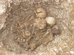 Larkhill - The community that built the Neolithic causewayed enclosure at Larkhill may have been the architects of the Stonehenge landscape, archaeologists believe.The causewayed enclosure, which dates between 3650 to 3750 BC - pre-dating Stonehenge by 600 years, was uncovered by archaeologists from Wessex Archaeology in 2016. Si Cleggett, project manager and archaeologist at Wessex Archaeology now believes the community who built the causewayed enclosure may have been more closely involved in the planning of Stonehenge than previously thought. He said: “The causewayed enclosure at Larkhill was constructed during the late Stone Age, a period of transition when our ancestors gradually moved away from a mobile hunter-gatherer lifestyle and embraced a farming existence where the domestication of livestock and control of agriculture began.” Causewayed enclosures are believed to be meeting places, centres of trade and cult or ritual centres to name but a few. They are only 70 known examples. Archaeologists believe there was a five post alignment at the entrance of the causewayed enclosure which were positioned almost identically to the stones of Stonehenge. Mr Cleggett said: “The communities who gathered at the Larkhill causewayed enclosure during the Early Neolithic were there 600 years before the landscape setting of Stonehenge was conceived and may have been involved in the conceptualisation or even the creation of the landscape we see today. The Larkhill site, which is 24 hectares, is the largest open area archaeological excavation ever undertaken in proximity to the Stonehenge World Heritage Site.
http://www.salisburyjournal.co.uk/news/16029809.New_theory_over_Stonehenge_origins/
USA – Patterson - Over a 400-year period that coincided with the Middle Ages in Europe, Native Americans lived at a site in what’s now western Sarpy County, south of Interstate 80 near Nebraska Highway 31. From about A.D 1000 to A.D. 1400, these families planted vegetables and fished in nearby waters. They made pottery and engaged in trade with other tribes. The inhabitants of this long-ago series of settlements, at what’s known as the Patterson site, were part of what archaeologists call the Central Plains culture. The site, included on the National Register of Historic Places, was especially rich in providing archaeologists with artifacts and other items that revealed how the residents lived. Residents “built and lived in permanent earth houses, grew crops and hunted a variety of wild animals,” the Nebraska State Historical Society explained in a 1998 report. “Their artifacts were beautifully crafted and included many tools, pottery vessels and ornaments. Farmsteads and hamlets of the culture are scattered along river and stream valleys throughout the eastern two-thirds of Nebraska and portions of adjoining states.” The way of life for the Central Plains people focused on permanent settlements, the raising of crops and the regular use of wood for various purposes. As a result, the report noted, their culture “was vastly different from the horse-riding, nomadic Plains Indian buffalo hunters of the 19th century.” Scholar David Wishart, a geography professor at the University of Nebraska-Lincoln, notes that Native American experiences in the Plains region stretch across 13,000 years.
ROYAUME UNI – Heslington East – The unique archaeology of Heslington East means that there is a strong possibility that a ceremonial burial ground used to stand where the Piazza Building has been erected. The archaeology on Heslington East is known for its strange findings. In 2008 the oldest human brain was discovered on Heslington East . The Iron Age skull was discovered in the centre of a muddy circular pit. The analysis of the skull upon its discovery reported that the vertebrae attached to the skull revealed that the man who it belonged to had been hung and then decapitated. However, the mysterious thing about this situation was that the head was then thrown down into a three foot ditch, leading experts to suspect that it was a ritual offering. The data collected on Heslington East reveals that there used to be an extensive prehistoric farming landscape of fields, trackways and buildings dating back to at least 300BC. There have been many unusual discoveries at Heslington East already. Prior to the discovery of the oldest human brain, a team from the University of York’s Department of Archaeology unearthed the skeleton of a man believed to be one of Britain’s earliest victims of tuberculosis. In addition, an isolated small pit was discovered on Heslington East to reveal a well crafted and polished Bronze Age battle-axe. The strange findings and sudden burials of skeletons and bodies on Heslington East therefore leaves open the possibility that beneath the new Piazza building or beneath Greggs there may have been pagan rituals and sacrifices. The history of Heslington East is well documented. 14 000 years ago the Vale of York was filled by a glacier moving south. This led to a large lake of melted water appearing in the south of the region. Ancient money was discovered by experts on Heslington East from the third and fourth centuries, meaning that money has been invested in Heslington East for 1700 years. A late Roman well was also discovered on site. Heslington East has historically been a site of community and action with evidence of settlers being on site from the Bronze and Iron Ages as well as a strong Roman presence being discovered.
http://www.nouse.co.uk/2018/02/16/piazza-building-may-be-built-over-ceremonial-ritual-ground/
TURQUIE –  Hierapolis - Is it possible to walk through the gates of hell and live? The Romans thought so, and they staged elaborate sacrifices at what they believed were entrances to the underworld scattered across the ancient Mediterranean. The sacrifices—healthy bulls led down to the gates of hell—died quickly without human intervention, but the castrated priests who accompanied them returned unharmed. Now, a new study of one ancient site suggests that these “miracles” may have a simple geological explanation. Rediscovered just 7 years ago, the gate to hell at the ancient city of Hierapolis, in modern-day Turkey, is a stone doorway leading to a small cave-like grotto. The gate was built into one wall of a rectangular, open-aired arena, topped by a temple and surrounded by raised stone seating for visitors. The city itself sits in one of the region’s most geologically active areas; 2200 years ago, its thermal springs were believed to have great healing powers. But a deep fissure running beneath Hierapolis constantly emits volcanic carbon dioxide, which pours forth as a visible mist. The gate—also known as the Plutonium, for Pluto, the god of the underworld—is built directly above it. In 2011, archaeologists showed that the gate is still deadly: Birds that fly too close suffocate and die. Now, a research team led by volcano biologist Hardy Pfanz at the University of Duisburg-Essen in Germany has studied the shrine’s killing potential in greater detail. Pfanz and his colleagues measured the CO2 concentration in the arena over time. During the day, the sun’s warmth dissipates the gas. But at night the gas—slightly heavier than air—billows out and forms a CO2“lake” on the sheltered arena floor. It is particularly deadly at dawn, when the CO2 concentration 40 centimeters above the arena floor reaches 35%, enough to asphyxiate and kill animals or even people within a few minutes, Pfanz says. But concentrations fall rapidly with height.
ISRAEL – Jerusalem -For decades it was known only as the “graffiti stone.” Leaning against a wall in a shadowy corner of Jerusalem’s Holy Sepulcher, the big blank rock the size of a dining-room table invited scribbling by passing pilgrims and tourists.But two Israeli researchers who recently examined the other side of the stone say the neglected artifact appears to be part of the high altar fashioned in the early 12th century by medieval Crusaders for the holiest church in Christendom, and upon which Mass was celebrated for more than 500 years. The stone’s intricate design, they add, is based on what was the latest Roman style and suggests a direct link to the papacy itself. The revelation highlights the complicated religious politics that still trouble Jerusalem.
https://www.smithsonianmag.com/history/crusader-era-high-altar-resurfaces-jerusalems-holy-sepulcher-180968192/
MYANMAR –  Myingyan - Archaeological evidence unearthed in the central Myanmar is thought to be from the Iron Age and the area is now designated as a heritage zone, according to the Department of Archaeology, National Museum and Library. The area in Myingyan District, Mandalay Region, was formerly used as pasture. A landslide during a road project revealed four holes which were suspected to be dug unofficially. Upon investigation, the deputy director of the department in Mandalay discovered bone particles, iron weapons and earthen pots and plates from the holes. Deputy Director Hla Shwe said: “We found eight skulls along with forearm and thigh bones. There are also pieces of pots, plates and iron weapons.” He said he thought the area was once inhabited by Iron Age people, given the unearthed iron tools. “Five hundred feet radius from the centre of the spot is designated as a heritage zone. We will have to dig deeper.” Statistics show Iron Age evidence is occasionally found along the Bago Range, Samone river valley and central parts of the country.
http://www.elevenmyanmar.com/local/13428
TURQUIE – Amasra - Residents in Turkey's Amasra district in the northern province of Bartın were surprised to find the beach along the coast littered with artefacts that were washed up from the Black Sea during a recent storm. The objects looked to be part of pillars and other building material typical of the Roman era. Newsweek reported that after a preliminary examination, it was confirmed that the ruins dated back to 90 BC to a time when the Anatolia region was part of the Roman Empire before being taken over by Byzantine and later Islamic rulers.