ARCHEOLOG-HOME / INDIana-UNIversitas
Contact


18 MAI 2011 NEWS : Mississippi River - Golden Cap - Pune - Dunkerque - Houston County - Oman - Panagyurishte -
- 18 MAI
- USA - Mississippi River - Water from the Mississippi River rushes out of open bays on the Morganza Spillway and into a pasture in Morganza, La., on Monday. Diversion of floodwaters has spared urban areas at the possible expense of rural historic and archaeological sites. there are about 530 known archaeological sites, ranging from a quarter-acre to up to about 10 acres, in the area where floodwaters will be diverted. Sites affected include remnants of a Civil War fort in Butte La Rose, as well as scores of Native American burial mounds and campsites and early Acadian campsites. Many of the Indian campsites, he says, are represented by what are known as shell middens, archaeological sites that contain discarded shells and other detritus of domestic life. There are likely thousands more such sites in the areas not surveyed. The Civil War fort, where earthen embankments are still visible on the ground, will certainly be inundated, officials say. Fort Burton, which once stood at the site, was captured by the Union Army in 1863. It was described by one Union soldier as a "grand rendezvous of mosquitoes, fleas, wood-ticks, lice, lizards, frogs, snakes, alligators, fever bacteria, dysentery microbes, and every conceivable type of malarial poison."
http://www.npr.org/2011/05/17/136396849/floods-threaten-historic-sites-not-tourist-favorites
- ROYAUME-UNI –  Golden Cap - Work has started to excavate three Bronze Age burial mounds on Golden Cap in Dorset. The 4,000-year-old mounds are at risk from coastal erosion and are being excavated before they are lost to the sea. There are five burial mounds visible on the summit of Golden Cap, the highest point of the coast path through Dorset at 191m (626ft) above sea level. The two mounds furthest from the cliff will not be excavated on this occasion. Each mound measures about 15m (49ft) in diameter. It is not known exactly how high each one is because they have been covered by sand blown in from the cliff edge. Each one currently stands at about 1m (3ft) high. Preliminary excavation work was carried out on the mounds in May 2009. It is hoped the current excavation will uncover more about the people who originally built them. All five burial mounds are expected to be lost through cliff collapses in the next 50 years. It is thought the mounds would have been about two miles inland at the time they were built. In June 1992 a trench was excavated across the south-west barrow, which dates to about 2000BC. It was found that 30% of this mound had already been lost through coastal erosion. In 1800 half of it was dug into to create a signal station to warn against attack by Napoleonic forces during the French invasion.
http://www.bbc.co.uk/news/uk-england-dorset-13439553
- INDE – Pune - It was while going through some Google images for research when city-based researcher Sachin Joshi noticed some wall-like structures at sites, which were not known to have forts. Thus began a journey to discover not one or two, but five unknown forts of the 15th and 16th century. He is also credited for mapping the forts with the help of global positioning system (GPS) and Google Earth for the first time. His two books — Raigad Jilhyache Durgavaibhav and Ratnagiri Jihyache Durgajignyasa — are based on the forts in Raigad and Ratnagiri districts respectively, which were released recently. Joshi, who works as a research assistant at Deccan College Postgraduate and Research Institute, has discovered two forts of Chhatrapati Shivaji among the five. Panhalghar in Mangaon taluka of Raigad district and Mohangad, near Bhor in Pune district were among the undiscovered forts of Chhatrapati Shivaji. Generally, forts were named after the villages, near which they were situated, so Joshi christened it as Panhalghar. This is one of the nine important forts around Raigad from where Chhatrapati Shivaji ruled his kingdom. “These forts around the capital aimed at keeping the enemy at bay,” said Joshi. He later went on to discover Mohangad in Pune district in 2009, situated on the border of Pune and Raigad district. This fort was only on papers until Joshi traced its exact location and went to Varanda ghats on Pune-Mahad route to find it. It’s about 30 km from Bhor near Pune. In one of his letters to Maratha warrior Baji Prabhu Deshpande, Chhatrapati Shivaji has mentioned the fort. “But no one knew where the fort exactly was. I traced it through the location that was mentioned in the documents,” state Joshi. The other three forts Manikdurga and Navate in Chiplun and Kasardurg in Guhagar are some of the other important forts in Konkan, which Joshi found in 2010. “These forts belong to the Vijaynagar empire. The art work on the remnants of the fort proves this. We traced the period of all the discovered forts through archeological evidences like the tanks, wall, coins and pottery that were discovered in the forts,” stated Joshi adding that the documentation of all these forts was essential for conservation purpose.
- FRANCE – Dunkerque - Les archéologues de l'Inrap ont poursuivi leur mission sur le centre-ville en s'intéressant, durant le mois d'avril, à l'ancienne emprise de Benjamin-Morel, plus particulièrement le coeur du lycée. Mathieu Lançon, responsable d'opérations à l'Inrap : « On remarque, à plusieurs endroits, une stratification qui débute au XIV-XVe siècles, à l'extérieur de l'enceinte de la ville. Il s'agit d'un niveau pas très urbanisé avec un aspect très rural, sur lequel on trouve des indices d'activité de métallurgie. Ce n'est pas de la grosse métallurgie, plutôt des traces d'activité du travail du fer. Il n'est pas non plus question de production de métal, mais de sa mise en forme, comme un atelier de maréchal-ferrant ou de forgeron... C'est très localisé et ne concerne qu'une petite surface. Un atelier d'artisanat pour cette période-là, ce n'est pas très courant. Rien d'autre pour ce qui concerne les XIVe-XVe siècles. Après cela survient le démantèlement des enceintes bourguignonnes et dès le XVIIe, l'agrandissement de la ville, avec le quartier qui commence à être loti. Au-dessus, nous avons retrouvé des murs de maisons postérieures, puis de la vaisselle, des verres, des déchets de consommation, ce qui n'a rien d'exceptionnel car on est en ville, datant du XVIIe siècle jusqu'à 1940. On identifie ensuite les traces de construction du lycée Benjamin-Morel, puis de sa démolition. Le terrain a été pas mal remanié et détruit suite à l'implantation de cet établissement. »
- USA - Houston County - Very little archaeology has actually been done in Houston County," Vogel noted. In spite of that many sites from both before and after European settlement have been identified. There are several hundred American Indian sites in Houston County. About a third of them were identified up until the mid-to-late'60s to the-late '70s in student training expeditions. Early archaeological surveys often focused on "burial mounds," Vogel said. By the late 1800s, 15,000 had been catalogued in Minnesota alone. Recent advances, such as LiDAR (light detection and ranging) elevation mapping, are finding more. "With LiDAR burial mounds pop up," Vogel said. "They're doing the bluffs along the river in Houston County now, and they're finding what are called effigy mounds, constructed between about 1000 to 1400 AD. Isolated thunderbirds and turtles..." "Native Americans have claimed the mounds as cemeteries now, so unless a mound is in danger of being destroyed by a waterways project or something, they're not excavated at all in the United States. "There's a bunch of mounds that are known along the Root River and along the Mississippi from La Crescent all the way down (to Iowa). Most of these are called Middle Woodland mounds and date from about 200 AD to 1000 AD. "They tend to be conical and they tend to have one burial in the middle and are about four to 10 ft. high. The ones located in pastures and fields are really hard to find. They're almost always along waterways. Mound building was a fad that lasted about 1,000 years. Nobody is really sure why they did it. "There's a school of thought that holds that burial mounds are really landscape architecture. Many do not contain burials. They could have been a way for people who traveled around a lot to be able to find the same place..."While there, important people who happened to die may be buried in that mound to commemorate that particular encampment... "Some complexes have hundreds of mounds." Vogel said he prefers the study of "middens," which are essentially leftover trash piles, to funerary remains, which have already received their share of attention. Middens tell how people lived from day to day, he noted.
http://www.hometown-pages.com/main.asp?SectionID=26&SubSectionID=137&ArticleID=37524
- OMAN – Muscat - A meeting of heads of archaeological missions operating in the Sultanate kicked off at the Heritage and Culture Ministry yesterday. The meeting discusses plans and procedures in archaeology through a five-year plan that meets the current and future demands in initial survey, documentation, archaeological plants and animal sciences, excavation, restoration and maintenance of non-movable and movable cultural property. Italian and French expeditions are working in Ras al Hadd and Ras al Jinz, US expedition in Bat, German expedition in Bat and Wadi al Ain in Ibri, French expedition in Qalhat, another US expedition in Thumrait and the Niyabat of Mudhi in Dhofar Governorate, another US team in the Wilayat of Yanqul and Dhank, a French expedition in the wilayats of Sur and Jaalan Bani Bu Ali, a British expedition in Bisya and Salut areas, a expedition in the Stone Age sites in Dhofar and a Swiss team in Duqm.
http://main.omanobserver.om/node/51531
- BULGARIE – 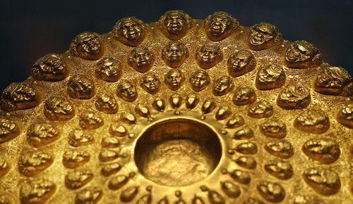 Panagyurishte – Sofia, Plovdiv and the town of Panagyurishte have been locked in a fierce dispute about the country's most prominent golden treasure for years. Now, however, Plovdiv has threatened the Culture Ministry with court action over ownership rights, Bulgarian National Television reported on May 18 2011. The archaeological museum in Plovdiv will sue the Culture Ministry it claims it is the only institution in the country with legitimate documentation proving that it is the rightful owner of the treasure. The treasure, also known as the Panagyurishte gold treasure, is permanently housed at Sofia's National History Museum in Sofia. It used to be in Plovdiv but, in 1974, it was relocated to the capital under the pretext that "Plovdiv could not provide sufficient security for the artifacts". The spoils are among the most prominent golden Thracian treasures in Bulgaria. The treasure was excavated on December 8 1949 by three brothers – Pavel, Petko and Michail Deikov – who worked together at the region of Merul tile factory near the town of Panagyurishte, Bulgaria. The excavation works and the archaeological team, which accomplished the feat, were hired by the Plovdiv archaeological museum. The artifact collection consists of a phial, an amphora and seven rhytons with a total weight of 6164 kg of 23-karat gold. Every item is beautifully and painstakingly decorated with tapestries of Thracian mythology, ancient customs and scenes of common daily life. Dated from the fourth to the third centuries BCE, they are believed to have been part of a royal ceremonial set by Thracian king Seuthes III.