ARCHEOLOG-HOME / INDIana-UNIversitas
Contact


17 - 18 DECEMBRE 2011 : Tours - Hawaii - Shaver Lake - Jersey - York / Toodyay -
17 - 18 DECEMBRE
INDI-UNI : ANTHROPOLOGY - ARCHAEOLOGY
INSCRIPTION 2012 COURS A DISTANCE
REGISTRATION 2012 ONLINE COURSES
FRANCE –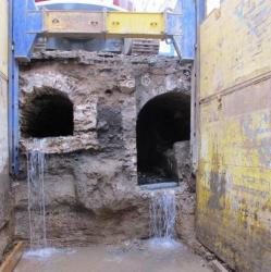 Tours - Deux sites de fouilles ont été creusés dans le cadre de l'aménagement du tram : au nord et rue Nationale. Les vestiges commencent à parler. Sur la totalité des quinze kilomètres de la première ligne, trois sites ont été retenus pour effectuer des fouilles archéologiques préventives sur prescription de l'État (Drac centre) : le centre de maintenance de Tours-Nord, Tours-Centre (rue Nationale et rue Charles-Gille) et Joué-lès-Tours (devant l'hôtel de ville). C'est d'abord à Tours-Nord que les archéologues du Service de l'archéologie du département d'Indre-et-Loire (Sadil) et l'Institut national de recherches archéologiques préventives (Inrap) se sont mis au travail. La fouille a révélé des occupations humaines comprises entre le V e siècle avant notre ère et le XI e siècle de notre ère. Les principaux vestiges concernent trois fermes gauloises qui se sont succédées dans le temps. « On voit sur ces trois occupations successives que les fermes deviennent au fil des siècles plus structurées. En fait, la grande surprise a été la découverte de la troisième ferme, sur le site du futur centre de maintenance du tram, qui date de - 60 à - 25 avant J.-C. C'est un établissement structuré, avec un grenier très certainement lié à la conservation de la production faite sur le site. » A Tours-Centre, l'opération de terrain vient de se terminer. « On commence juste les post-fouilles, a précisé Amaury Masquilier, directeur de l'antenne tourangelle de l'Inrap. Nous avons donc peu de recul. » Et pourtant, les résultats sont bien là puisque « les recherches réalisées rue Charles-Gille ont révélé une occupation antique jusque-là insoupçonnée, ainsi qu'une série de squelettes datés du XIV e siècle, correspondant peut-être aux victimes de la grande peste noire. Rue Nationale, une ancienne voie utilisée durant toute l'Antiquité, reprenant le tracé actuel de la rue, a été mise au jour. En plus, une portion de l'enceinte du XIV e siècle précédée d'un fossé large de 20 mètres a été observée au niveau des rues Emile-Zola et Néricault-Destouches. » Les fouilles en centre-ville se sont déroulées dans des conditions difficiles, notamment en termes d'accès, « puisque les fouilles se faisaient à l'intérieur de blindages, a continué Amaury Masquilier.

USA – Hawaii - Hulihe'e Palace once belonged to the royal family of the Kingdom of Hawai'i. It varied from a summer retreat to main residence for different royal family members. Today it is maintained as a museum by the Daughters of Hawai'i. Hulihe'e's Palace was the first of three wahi panas chosen for digital preservation on the Big Island. A wahi pana is a "place" of significant meaning in the Hawaiian culture. This project set out to digitally preserve a few important wahi pana of the Big Island in an effort to raise awareness of the need for digital preservation efforts in the island state of Hawai'i. The project utilized laser scanners and digital photography to record three sites. The data was then archived and processed into educational and interpretive deliverables to be freely shared with the world via the CyArk website (www.cyark.org). The planned documentation of the three wahi panas would be conducted by CyArk and our partner, Gauge Point Calibration (Trask's commercial firm, of which he volunteered his time, equipment, and expenses for the good of this pilot effort). We spent two days at the Hulihe'e Palace capturing the structure in near entirety (one room was off limits for any kind of imaging—photographic or laser—due to the cultural sensitivity of the artifacts within). The interior of the house had a no-shoes policy to protect the beautiful hardwood flooring so we used rubber mats to protect it from the harsh metal tripod footings. And with the cool, soft grass in the warm sun outside, there was little reason to put them back on when moving between the interior and exterior machines. It was the first project I've ever conducted barefoot! It was certainly easy to let the Hawaiian lifestyle easily creep into our workflow. The data for the Palace will be used to promote the site and raise awareness of its important history in the Hawaiian Kingdom. It will also function as a base data set for future repair or restoration in the case of damage. The palace had previously suffered extensive damage in the 2006 earthquake and had only just finished final repairs. The data set we created could provide information necessary for intricate moldings and furnishing should future damage occur. Additionally, it is possible to interpolate historical reconstructions. Approximately 50 years after its original construction the Palace was plastered over to make it more European in style. Through historical photographs of the Palace and sample data collected at the Mokuaikaua Church across the street (built at the same time by the same architect), digital 3D models of Hulihe'e Palace can be created showing it in its original appearance of mortar and lava rock. Or, the hut formerly on the property and used nightly for sleeping by Princess Ruth can be digitally reconstructed and reinserted to achieve a digital recreation of the historical landscape. Princess Ruth did not enjoy sleeping in her European-styled palace, and preferred her traditional hut and mats and so retreated to the on-site hut each evening. The hut's original location is now crossed by the modern Ali'i Drive, but the original stepping stone remains (and was also scanned). These types of interpretive elements will allow visitors to travel through time at the site, seeing its evolution and change. At the conclusion of field work for Hulihe'e Palace, Trask and I traveled south from Kona to Pu'uhonua o Honaunau National Historical Park (also known as "the Place of Refuge"). CyArk has had an extensive relationship with the US National Park Service, documenting eight sites to-date (not including work in Hawai'i) and this trip provided a rare opportunity: the Place of Refuge park had just purchased its own Leica C10 3D laser scanner, but had yet to use it. Trask and I were able to conduct a hands-on training exercise with the NPS staff, teaching the basic operation and data capture methodologies. Together, the team documented a reconstructed canoe shelter and a portion of the "Great Wall" of the site, and partial exteriors of a heiau (a temple or shrine) and its surrounding ki'i (a large wood or stone carving, also known as a tiki in other Polynesian cultures). The "place of refuge" was exactly that to ancient Hawaiians. It acted as a sanctuary for those escaping punishment (usually death) for breaking a kapu (laws of taboo) or could even be a haven for enemy warriors escaping capture. As long as you could get there alive, you'd remain so. But the people didn't make it easy to get there. The sacred place of refuge was surrounded by a massive, thick wall of lava rock. Nicknamed "the Great Wall", it was to help keep people out, including attempted asylum seekers. If you happened to survive the chase and scale the wall, your fate was then in the hands of the attending priest. The priest could choose whether or not to absolve your sin of breaking kapu. If the priest didn't choose to absolve you, you wouldn't want to walk back out. You could, however, either stay inside the wall indefinitely or maybe make a swim for the next island. Options were few, and not ideal.
http://www.amerisurv.com/content/view/9474/
USA – 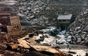 Shaver Lake - Shaver Lake will remain completely drained this winter while contractors hired by lake operator Southern California Edison place a protective liner along bottom sections of the dam's concrete surface to guard against erosion and leakage. Water levels are expected to return to normal by Memorial Day weekend. But the 170-foot-tall "new" dam, completed in 1927 to provide hydroelectric power, isn't what's creating the fuss. That honor belongs to the 50-foot-tall, 300-foot-long, rock-fill dam built in 1893 by the Fresno Flume and Irrigation Co. for its lumber mill operation. In its day, the mill pond created behind the old dam stored 5,000 acre feet of water, a fraction of the size of modern-day Shaver Lake. Processed lumber from the mill was then delivered to the Valley by way of a 42-mile-long wooden flume that snaked down the mountain to the present site of the Clovis Rodeo Grounds. What's remarkable is that much of the heavy machinery that powered the lumber operation -- an old steam engine, drive wheels, boilers, remnants of smoke stacks, even a steam ship -- is still down there. Except with the lake drained, these artifacts are visible instead of sitting beneath 120 feet of water.
http://www.fresnobee.com/2011/12/18/2653359/shaver-lakes-history-exposed-as.html
ROYAUME UNI – 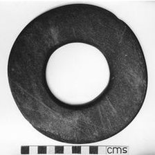 Jersey - A Neolithic stone ring which dates back more than 7,000 years is to be returned to Jersey. La Societe Jersiaise and Jersey Heritage bought the polished jadeite ring for $17,500 (£11,291) at auction. The ring, which was found in 1986 and sold to a private collector in 1993, is considered to be one of the island's most valuable archaeological treasures. It is made from stone quarried in the Alps and was brought to Jersey by the first farmers who colonised the island.
http://www.bbc.co.uk/news/world-europe-jersey-16223233
AUSTRALIE –  York / Toodyay - AFTER tireless hours of digging, University of WA Doctor of Philosophy student Sean Winter is close to unearthing little-known facts about York and Toodyay’s convict past. Among the finds are the remains of three York convict depot buildings, seven Toodyay convict buildings, broken clay pipes, old bottles and other artefacts that could well provide some interesting insight into the Avon Valley’s criminal history. Following excavations in the two towns, Mr Winter has published a research article in this month’s premier archaeology journal Australian Archaeology that reports on his progress. He said the principle aim of the dig was to investigate the regional convict way of life, the relationships between the various groups that made up convict establishments and the impact of prison life on regional society. “We are looking at the day-to-day lives of convicts because a lot of the history is about the prison system rather than their lifestyle,” he said. Though analysis is ongoing, Mr Winter said the irregular structure of the buildings suggested construction was poorly supervised and there was a high turnover of “ticket-of-leave” men. The ticket system began in 1853. Prisoners transported from the UK to Australia who had served a period of probation and shown good behaviour could be allowed certain freedoms. Once granted a ticket of leave, a convict was permitted to seek employment in a specified district but could not leave that district without the permission of the government. Each change of employer or district was recorded on the ticket. Mr Winter said his investigations were starting to uncover how prisoners around York and Toodyay lived.
http://www.inmycommunity.com.au/news-and-views/local-news/Digging-up-our-convict-past/7610578/