ARCHEOLOG-HOME / INDIana-UNIversitas
Contact


16 NOVEMBRE 2011 NEWS
16 NOVEMBRE
INDI-UNI : ANTHROPOLOGY - ARCHAEOLOGY
INSCRIPTION 2011 – 2012 COURS A DISTANCE
REGISTRATION 2011 – 2012 ONLINE COURSES
ROYAUME UNI – Rhynie - A Pictish "seat of power" has been unearthed by a team of archaeologists in an Aberdeenshire village. An excavation of the site south of Rhynie has revealed a medieval settlement and artefacts that would have positioned the village as a seat of major political power and influence, according to Rhynie Environs Archaeological Project (Reap). The dig was organised after eight carved Pictish symbol stones were found near the site between the 19th century and the 1970s. During the excavation the team uncovered burnt material, stone, Roman pottery, metalwork, glass and animal bone within a "substantial system" of fortification. The Reap team said these artefacts will provide fresh information about the Picts who they say are one of Britain's "most mysterious groups". Between AD 400-900 the kingdoms of the Picts are believed to have become some of the most powerful political groups in the north of Britain. However, the project team said there is little documented history and archaeological record about them. The symbol stones help to provide a record of Pictish identity, beliefs and lifestyle. The team said many of the finds at Rhynie, such as a small shard of glass identified as a drinking bowl from the 6th or 7th century, suggest the site was once a place for those of high status, associated with fine dining and drinking.
FRANCE – Cambrai - Parmi les personnalités venues sur place apprécier l'étendue de la découverte figurait le conservateur régional de l'archéologie Stéphane Révillion. Concernant les morceaux statuaires déterrés, « récupérés dans les fondations d'un bâtiment », le conservateur décrit « des gens représentés en cuirasse, des pieds qui terrassent un animal mort... Ils proviennent très certainement d'un bâtiment officiel, sans doute d'une façade, car ces statues qui devaient mesurer 2 m à 2,5 m étaient destinées à être vues de loin ». Quant à leur origine, S. Révil-lion rappelle : « On est dans le périmètre de l'ancien hôpital Saint-Jean et de la chapelle qui s'élevaient ici jusqu'au XVIIe et XIXe siècles. (NDLR : l'église avait été transformée en bibliothèque). Est-ce que ces éléments appartiennent à ces bâtiments-là ? Seule une étude un peu plus poussée permettra de le déterminer... »
FRANCE –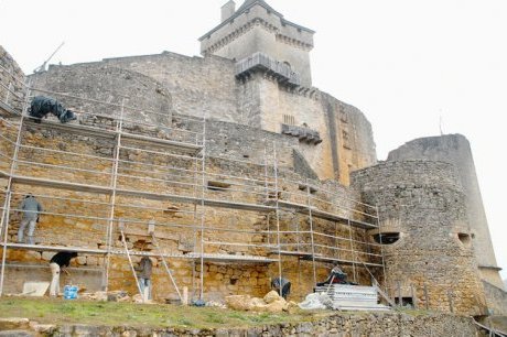 Castelnaud - Après avoir bénéficié de trois spectaculaires campagnes de restauration entre 1970 et 2005, le château de Castelnaud joue les vieilles dames coquettes et se fait offrir un nouveau lifting. Supervisé par l’architecte en chef des monuments historiques Philippe Oudin, le projet de restauration prévoit la reprise des maçonneries de la première enceinte du château, de la tour de la barbacane et de la tour d’artillerie. Parallèlement, une fouille d’archéologie préventive est réalisée par la société HADES, dans la basse et la haute cour du château. Terrassement, fouille manuelle, étude de mortier et relevé pierre à pierre occuperont l’équipe d’archéologues pendant 3 semaines. Cette étude archéologique nous permettra peut-être de faire une chronologie plus précise des différents axes de circulation et de leur système de protection. L’étude de l’implantation successive des différentes barbacanes mise en corrélation avec l’étude des ouvertures de tir nous permettrait de définir le plan de feu de la forteresse. Une chose est sûre, le château de Castelnaud s’est continuellement adapté aux progrès de l’artillerie et a donc subi des transformations entre le XVe et le XVIIe siècle, afin d’être en mesure de se défendre parfaitement grâce aux engins d’artillerie.
http://www.espacedatapresse.com/fil_datapresse/consultation_cp.jsp?idcp=2726281
SUEDE – Oland - A shipwreck discovered in the murky waters of the Baltic Sea is believed to be a legendary 17th century warship whose captain went down with it in battle rather than surrender to the enemy. Deep Sea Productions, an underwater research team, said Wednesday it believes the 25-meter (82-feet) wooden wreck it found off the island of Oland this summer is the ship Svardet, which sank when Sweden was defeated by a Danish-Dutch fleet in a 1676 naval battle. Malcolm Dixelius, a member of the research team, said that wood samples show the wreck is from the 17th century. He also said the stern of the ship is missing, which is consistent with historical reports that Svardet went under after a fire and explosion at the stern. Thousands of other wrecks — from medieval vessels to warships sunk during the world wars — have been found in the Baltic Sea, which doesn't have the ship worm that destroys wooden wrecks in saltier oceans. Earlier this year, the same research team discovered the 16th century warship Mars at a nearby location. The ship Kronan was discovered in 1981, yielding more than 30,000 archaeological artifacts. Svardet and Kronan were lost in the same fight, described as the largest naval battle in the history of the Baltic Sea. According to historical reports, Svardet was set afire by a Dutch ship after a five-hour battle. The commander, admiral Claes Uggla, refused to abandon his ship as it went down.The research team had been searching for Svardet for more than 10 years when it found it between the Swedish islands Gotland and Oland at a depth of between 50 and 100 meters, surrounded by the hundreds of canons it carried when it went under.
USA – Smithfield - Archaeologists working at St. Luke’s recently discovered at least 11 unmarked graves behind the circa 1640 church. Also found was a tobacco pipe bowl dating back to the 17th century. The graves, unknown to church officials before the work was done, were not a surprising find, said Nicholas Luccketti, lead archaeologist on the project with James River Institute for Archaeology. Evidence of the graves was found about 18 inches under the surface and on each side of the church, facing east-west as is customary, Luccketti said. There were soil stains about two to 2.5 inches wide with good straight edges, he said. The graves were regularly spaced and at the time, church members must have known they were there because there were no later graves cutting across the earlier ones, Luccketti said.
AUSTRALIE – Bunbury - Excavation of two possible shipwreck sites on Koombana Drive will start next week. The purpose of the excavations is to identify several anomalies found during magnetometer and ground penetrating radar surveys commissioned by the City of Bunbury in 2009. These anomalies could be the remains of shipwrecks known to have been lost in the area which was the shoreline in 1896 and has since changed significantly due to port and harbour development. There are at least 12 protected shipwreck sites in Bunbury.
BULGARIE – Momchilgrad - An archaeological site in Bulgaria, including remnants of a village said to date back 8000 years, has been destroyed by bulldozers, allegedly the work of a construction company building part of a new road from Bulgaria to Greece. A special commission from the Ministry of Culture is inspecting the damage to the site, near Momchilgrad, and police are investigating. Zharin Velichkov, chief inspector of the Bulgarian Ministry of Culture said that the site had individual layers dating back thousands of years, believed to reach back as far as 6000 BCE. He said that he could not say who had committed the destruction but it was most likely the company that had been carrying out work in the area. The construction company had been given accurate maps of the area, with archaeological sites marked. The mound of the site, which also included a medieval church, were a few hundred metres from the planned road to Greece. Archaeologists are now trying to rescue anything remaining after the bulldozing.