13 MAI 2024 NEWS
INSTITUT SUPERIEUR D'ANTHROPOLOGIE
INSTITUT OF ANTHROPOLOGY
COURS ONLINE – COURS A DISTANCE
INSCRIPTIONS OUVERTES
REGISTER NOW
IRAQ – 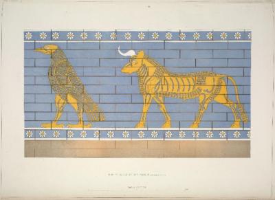
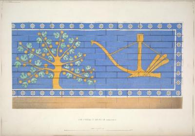
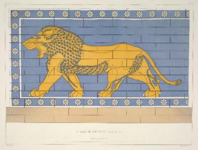 Khorsabad - A new interpretation of a set of temple symbols that have puzzled scholars for more than a century has been put forth by an Assyriologist. The ancient symbols, found in a 2,700-year-old temple in the city of Dur-Šarrukin in present-day Khorsabad, Iraq, include a lion, an eagle, a bull, a fig tree and a plough. The ancient city of Dūr-Šarrukīn, meaning “fortress of Sargon” was home to King Sargón II, ruler of Assyria from 721-704 BCE. He was revered as a great king who established the Sargonid Dynasty, which lasted for an additional century before the collapse of the Neo-Assyrian Empire. He was a patron of the arts and especially enjoyed erecting monuments. The ancient symbols tend to appear in the same sequence consisting of a lion, eagle, bull, fig tree and a plough and these symbols were prominently displayed on temples throughout the ancient city. French excavators who visited the site at the end of the 19th century were the ones who first documented and shared them with the public. Since their rediscovery, many researchers have attempted to interpret their meaning. Some believe they are like Egyptian hieroglyphs, some sort of expression of imperial power, or may even spell out the king’s name. But how these connections could be made remained a conundrum. An Assyriologist from Trinity College Dublin named Dr. Martin Worthington has offered a convincing analysis of these symbols that has the potential to completely change our perception of ancient Mesopotamian iconography. In his recent article in the Bulletin of the American Schools of Oriental Research, Dr. Worthington put forth a groundbreaking hypothesis: the sequence of five symbols may spell out Sargon’s name (šargīnu), while also representing specific constellations. “The study of ancient languages and cultures is full of puzzles of all shapes and sizes, but it’s not often in the Ancient Near East that one faces mystery symbols on a temple wall,” Dr. Worthington explained in a statement. What is more, according to Dr Worthington, each of the five symbols can also be understood as a constellation. Thus, the lion represents Leo, and the eagle Aquila (our own constellations are largely inherited from Mesopotamia, via the Greeks, so many of them are the same). The fig-tree stands in for the hard-to-illustrate constellation ‘the Jaw’ (which we don’t have today), on the basis that iṣu ‘tree’ sounds similar to isu‘jaw’. “The effect of the five symbols, was to place Sargon’s name in the heavens, for all eternity – a clever way to make the king’s name immortal. And, of course, the idea of bombastic individuals writing their name on buildings is not unique to ancient Assyria…” Although Dr. Worthington admits that his theory cannot be proven beyond a reasonable doubt, the fact that it holds true for both the longer three-symbol sequence and the five-symbol sequence suggests it is more than just a coincidence.
Assyriologist solves archaeological mystery from 700 BC in Khorsabad, Iraq - Arkeonews
ANGLETERRE – 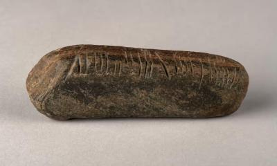
 Coventry -A geography teacher, Graham Senior, stumbled across a rock with mysterious incisions while tidying his overgrown garden in Coventry, England. The discovery of a small stone carved with an early form of Celtic script has caused excitement among archaeologists. The 11-centimeter-long and 139-gram rectangular sandstone rock had cryptic inscriptions on it that suggested a history spanning over 1,600 years, all written in the mysterious Ogham alphabet. Ogham is an early medieval alphabet used to write the Archaic Irish language from the 4th to the 6th century and Old Irish from the 6th to the 9th century. It is usually found carved on stones in Ireland, Wales, and western Britain. It was the first written language in Ireland. The majority of the 400 or so known inscriptions from the Archaic Irish period are family name pillars that were built to announce land ownership. Ogham is an extremely unique writing system among all writing systems, with lines arranged in groups of one to five only. The stones provide insight into the Irish language before the use of the Latin insular script. Professor Katherine Forsyth of Celtic Studies at the University of Glasgow conducted additional research that shed more light on the stone’s provenance. Her findings point to a period suggesting a timeframe ranging from the fifth to sixth centuries, with the possibility of an even earlier date in the fourth century. The stone is inscribed on three of its four sides. The inscription on the stone, “Maldumcail/S/ Lass,” puzzled researchers, with interpretations pointing towards a version of the personal name Mael Dumcail, but the meaning of the S and LASS is unclear. Given the usual purpose and significance of ogham stones, it may be a location reference. Theories regarding the origins of the stone abound, with speculations ranging from migration patterns to the presence of early medieval monasteries in the region.
Teacher unearthed stone with ancient ogham writing from Ireland in Coventry garden - Arkeonews
JAPON – 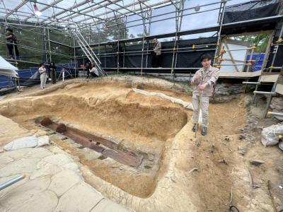 Nara - From the outside, the Tomio Maruyama burial mound in the city of Nara is unimpressive — the fenced-off property dotted with tree stumps, weeds and pebbles, and surrounded by modern residential buildings, certainly doesn't look like a treasure trove full of items with astounding historical value. Yet in late 2022, a giant iron sword and a bronze mirror were unearthed from the tomb grounds, which date back to the late fourth century. The news stunned the nation, including even the most experienced archaeologists. The 2.3-meterlong dakо̄ken sword — called that due to its wavy snake-like shape — is by far the longest sword found in East Asia from the Kofun Period (310 to 700), and possibly the world. It is also the oldest among the 90 or so dakо̄ken to have been discovered so far across Japan. In another surprise, the bronze mirror — elaborately decorated with images of gods and animals — is shaped like a shield. Ancient mirrors are typically round; none with such a shape has ever been found. The sword was unveiled to the public from late March through early April at an archaeological museum in the city of Kashihara, Nara Prefecture
How the discovery 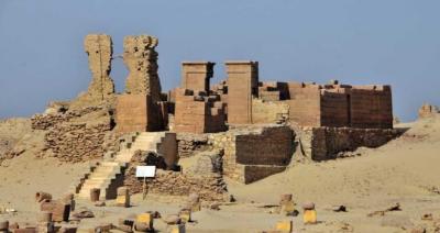 of a giant sword in Nara offers clues into ancient Japan - The Japan Times
EGYPTE – Karanis - New research results are rewriting the history of Karanis, an ancient Greco-Roman agricultural settlement in the Fayum oasis in Egypt. The study’s findings contradict the conventional wisdom that the location was abandoned in the middle of the fifth century and indicate that this location may have been inhabited until the middle of the seventh century AD. These dates round out the intricate picture of population swings and the renovation and repurposing of Karanis’ architectural legacy. This finding suggests that the settlement remained still active during a time of significant political and environmental changes in the region and beyond. Founded in the Fayum region of Egypt circa 250 BC, Karanis was home to a farming community with a varied populace and an intricate material culture that persisted for hundreds of years. Karanis, which was eventually abandoned and partially covered by the encroaching desert, turned out to be an extraordinarily rich archaeological site, yielding tens of thousands of artifacts and papyrus texts that provide a wealth of information about daily life in the Roman Egyptian town. Thanks to the radiocarbon dating of thirteen samples of plant remains taken from the settlement’s structures, the chronology of Karanis was reexamined. The crops’ age was determined with the assistance of the 14CHRONO Centre at Queen’s University Belfast, which carried out the dating. These findings suggest that the site was occupied for a longer period of time than previously believed. The chronological framework for the site was established by the first excavators through papyrological and numismatic evidence. Based on papyri and coins from the first excavations conducted between 1924 and 1935, as well as the materials’ scarcity after approximately 460 AD, researchers came to the conclusion that Karanis was abandoned at that time. This implies that events such as the Antonine Plague (AD 165–180) and the ensuing economic downturn caused the settlement to be abandoned. The research indicates that while there may have been depopulation in certain parts of the settlement by the middle of the 5th century, there were still inhabited areas up until the 7th century, which coincided with the Islamic conquest of Egypt. This result defies earlier inferences that suggested an early decline based on papyri and coins. The settlement appears to have changed gradually over time, with buildings being renovated and repurposed. It is known that there were notable variations in the climate and Nile levels during this time, and that Byzantine and Arab conquests also altered the political landscape. These dynamics may have allowed some areas of Karanis to remain active while abandoning others, thereby influencing the survival and transformation of the region. The settlement was continuously inhabited beginning in the sixth century, and it seems to have endured in some capacity at least until the Islamic conquest in the seventh century AD, according to the researchers. With the available data and without a deeper understanding of its shifting urban fabric, it is challenging to determine how much of its prosperity it retained. However, researchers do concede, though, that it is also unclear how and when Karanis was ultimately abandoned; the lack of coins and papyri does not necessarily mean that there was no population there.
USA – 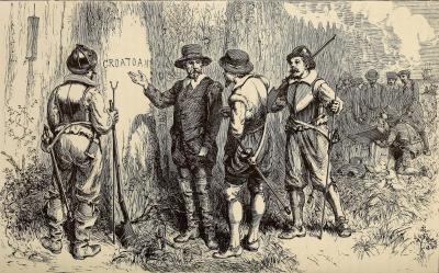 Roanoke - The story of an English settlement known as the “Lost Colony” of early explorers of Roanoke and Sir Walter Raleigh is one of the most fascinating mysteries in American history. John White led a party of roughly 115 English settlers who arrived on Roanoke Island, which is located slightly off the east coast of modern-day North Carolina, in 1587. The first attempt to colonize the island had failed a few years prior, so the settlers were the second group to try. Even from their first days, the settler community had a rocky relationship with some of the Indigenous tribes that lived in the area. Eventually, White returned to England to request more help for his burgeoning community. Along with the other settlers, he left his wife, daughter Eleanor Dare and her husband Ananias Dare, and his infant granddaughter Virginia—the first English child born in America—to continue building the colony. White arrived in England at the same time as the Spanish Armada prepared to invade the nation, which unfortunately caused a delay in his return to the colony. By the time he returned to Roanoke in 1590, his family and the other settlers had vanished. The word “Croatoan” carved into a tree provided the only meaningful hint as to what had happened to them. The word probably referred to Croatoan Island, about 50 miles (80 kilometers) south. There are various explanations for what happened to today the “lost” Roanoke colony settlers. Some believe the colonists attempted to return to England on smaller ships, some argue that the Spanish attacked them, while others contend that the local Indigenous communities killed them all. Still, the most plausible response is the only one that genuinely observes the evidence at the location. Most likely, the colonists just became part of the local Indigenous communities and eventually blended in. Recently, researchers have concentrated their efforts on the Elizabethan Gardens in Manteo in an attempt to learn more about the fate of the English settlers. There, they found additional evidence of a farmstead that belonged to the Indigenous community known as the “Algonquian village of Roanoke” (also spelled Roanoac), which hosted the explorers in 1584. Excavations in March 2024 followed discoveries in the summer of 2023, when archaeologists from The First Colony Foundation uncovered what they believe are tantalizing clues. They dug up shards of Algonquian pottery dating back to the 1500s, along with a ring of copper wire they believe could have been an earring once worn by a warrior from an Indigenous tribe. “Finding domestic pottery—the type used for cooking—in close proximity to an apparent piece of Native American jewelry strongly confirms we are digging in the midst of a settlement,” said Dr. Eric Klingelhofer, the First Colony Foundation’s Vice President of Research. “And Roanoac is the only known village at that site.” “The copper ring indicates contact with the English,” Klingelhofer continued. The ring was made of drawn copper, and Klingelhofer believes it was brought to America by English explorers as part of their trade goods. Indigenous peoples did not have the technology to produce such rounded strands, and neither the French nor Spanish explorers ventured as far north as Roanoke Island to trade. The copper ring would have made for a valuable trade item. Historians say copper had spiritual significance for Indigenous tribes. While artifacts were discovered last summer, the objective of the more recent dig was to find evidence of a farmstead where Algonquian families lived, worked and farmed. Archaeologists recovered charcoal and shards of Algonquian cooking pots. Evidence from the past two digs appears to confirm a theory that the village of Roanoke was palisaded (surrounded by high walls) with about nine houses where the elite warrior class lived. The working class lived outside the walls on farmsteads, raising crops for themselves and the ruling class. “The objects we found are important, but it’s their relationship to different soils which are evidence of links to the past, and together that’s what tells the story,” said Klingelhofer. “And we’re beginning to see that this site was more of a capital with a tribal seat where a ruler or chief lived, and it would be palisaded to keep him safe.” The chief presided over a territory that comprised present-day Dare County, Roanoke Island and parts of the mainland at the time of English exploration and colonization. “The new findings confirm a theory that matches what we know of the village,” added Klingelhofer. “It was described as a palisaded village because the explorers came here and recorded it. And these findings add to our story.” History shows the colonists said they intended to move about 50 miles into the mainland; Salmon Creek is about that distance. The First Colony Foundation has been working at two sites in that area for years, and researchers are looking for a third site. Another exploration is scheduled for this summer at nearby Fort Raleigh National Historic Site. The goal is to find evidence of the colonists’ original settlement.
Archaeologists find new clues about North Carolina's 'Lost Colony' from the 16th century - Arkeonews