13 JANVIER 2014 NEWS: Adena Mound - Balouchistan - Omey island - Sheriffside - Troodos - St. Augustine - Meayll Peninsular -
INSTITUT SUPERIEUR D'ANTHROPOLOGIE
INSTITUTE OF ANTHROPOLOGY
ONLINE COURSES / COURS A DISTANCE
SPRING TERM : APRIL 2014
REGISTER NOW
USA – 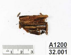 Adena Mound - A new set of testing on the Adena Mound has yielded results indicating it was built during the first century of the Common Era. Ohio Historical Society archaeologists, in partnership with researchers from the private Cultural Resource Management firm Gray & Pape and Ohio State University, conducted the radiocarbon testing. The new dates will be reported in an article in the February issue of Midcontinental Journal of Archaeology. The Adena Mound was located at Adena Mansion and Gardens in Chillicothe, the estate of former Ohio Governor and U.S. Sen. Thomas Worthington. The mound was excavated by the Ohio Historical Society’s Curator of Archaeology, William C. Mills, in 1901.But, at the time, Mills had no way to find out the age of the mound. Fifty years later, radiocarbon dating was invented.Dates were obtained on two samples of bark and one fragment of textile. The bark produced dates of around A.D. 40, whereas the textile gave a date of 140 B.C. The explanation for why the textile appears to be so much older may be that the Adena people used an heirloom garment or shroud in the burial.
PAKISTAN – Balouchistan - The archaeology and cultural heritage of not only Kech-Makran but also the entire archaeology of Balochistan is neglected. Kech-Makran is considered to be the southwestern maritime division of the Kalat State, Balochistan. It is a trans-migrational route of South-Central Asia and it has witnessed several movements in the region.Similarly, this region developed highly advanced cultures that are unique in the world. Furthermore, if we have a glance at the exact geography of Kech, it is situated in a central location, connecting the Iranian plateau, on the one hand, and the Indian plateau on the other. It also joins the Middle East and southwest Asia to Central and South Asia. Besides, it formulates the adjoining marine outlook for the landlocked states of Central Asia.Additionally, the nature of the area is the contrast of a green oasis and river valleys with the mountainous ridges and hard salty desert. Similarly, the nature of the people is believed to be the same. They are considered to be simple, nomadic and living a village – cultural type of a life. Nomadism, however, emphasises the sources of tribalism and feudalism in the region. Historically, most of the people have been nomadic, semi-nomadic, and camel nomadic people and the same exists in some of the Kech-Makrani regions in the present time. Kech is believed to be incredibly rich in the field of archaeology because it has witnessed numerous invasions. Alexander the Great and his army in 327 BC is a case in point. In this respect many archaeological excavations and research have been conducted. Research was first carried out by a Brit named Major Mockler. The process continued until late 2006 by Frenchman Roland Besenval. After much research and excavations, the findings, the objects and the remains suggested that these people were technologically advanced and they had a developed social structure. This is known due to the signs and symbols of some of the aspects of their domestic life because the domestication of plants and animals was practiced. It is, nonetheless, not well – known that how their physical features were, what characteristics they had, what faith they believed in, and what particular cultural norms the practiced. Overall, the valued fact in the particular study is that the Miri settlement flourished in 6,000 BC and it survived till the Islamic era. On the other hand, the archaeology and cultural heritage of not only Kech but also the entire archaeology of Balochistan is neglected. Thus, the archaeology and the cultural heritage of these regions need special interest so that 8,000 years of history is saved and the people are aware of their genuine heritage.
http://www.sharnoffsglobalviews.com/balochistan-neglected-archaeology-279/
IRLANDE - 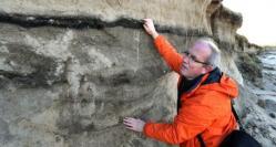 Omey island - Destruction wreaked along Connacht’s coastline in the recent storms has exposed archaeology dating back to the Neolithic period on Connemara’s Omey island. Large linear archaeological deposits of up to a metre thick have been exposed on the western and northern shorelines of the tidal island off Claddaghduff. Two sets of medieval burial sites, traces of sunken dwellings and parts of a Neolithic bog, which had been covered over millenniums by shifting sands, have been revealed.Out on Omey in recent days, as winds and swell began to ease, Mr Gibbons confirmed that sand-cliff sections up to 100 metres long had revealed the archaeological deposits. The burial sites now visible were part of a medieval settlement excavated in the 1990s by Prof Tadhg O’Keeffe of University College Dublin, when an earlier storm revealed traces of a monastic enclosure, he said. The sunken houses of which there are traces date from the 18th and 19th centuries, while the churning up of an ancient bog by recent tidal surges has turned blue sea to brown. Mr Gibbons estimates the bog, at the base of the sand cliffs, to be at least 6,000 years old. Féichin Mulkerrin, who works for the Office of Public Works, said middens on Omey were affected. Twenty metres of sand was dislodged in the swell on the northwest, while the sea came right up to the gate of the new graveyard. “We haven’t had tides this high since 1991 and previous to that in 1963, and it was the series of tides that really made an impact, affecting all of the islands,” Mr Mulkerrin said. Midden deposits extending from inner Galway Bay, up by Dog’s Bay near Roundstone to Mulrany in Mayo were lost, with one of the oldest in Connacht, a late Mesolithic midden site on the Renvyle peninsula, also being a casualty.
ROYAUME UNI –  Sheriffside - The final phase of a hillfort reflecting major changes on the impact of Roman rule in Scotland during the 3rd and the 4th c. AD is currently studied by archaeologists in Sheriffside, East Lothian, 20 miles E off Edinburgh. Back in 2012, archaeologist representing Rambart Scotland started to investigate the site of Sheriffside, revealing a ditch measuring over 8m across and up to 2.80m deep. According to Past Horizons, this is the largest ditch discovered in the region so far and has produced a C14 date range of AD 211-384. The third and fourth century AD represent a period of upheaval for borderline areas of the Roman Empire, and Scotland is not an exception. With the Romans withdrawing behind Hadrian’s Wall, the Picts, people of the North carry out frequent raids and the Romans occasionally striking back, forcing local tribes whetherin friendly terms with the Empire or just neutral, into taking defensive action to protect themselves and their livestock.“The wild tribes of the Scots and the Picts broke their undertaking to keep peace, were causing destruction in those areas near the frontiers, and the provincials, exhausted by the repeated disasters they had already suffered, were caught in the grip of fear…” writes ex-Roman officer and author Ammianus Marcellinus (Res Gestae, Book XX, chapter 1). According to Marcellinus, several tribes agreed to join forces and conquer Brittania in a key event to the so called “Pictish Wars” of that period, in the framework of numerous similar barbaric raids against the Empire’s borders (known as “Barbarian Conspiracy”Res Gestae, Book XX, chapter 4). Within the archaeological context, this upheaval is likely represented byLate Roman signal towers to the E. of England, a knife handle inscribed with pictish characters from Norfolk and an increase in teh deposition of coin hoards along the 4th century. An inscription on the 4th century AD Vettweiss-Froitzheim Dice Tower (Hall 2007, 3) proclaims in Latin: “Pictos Victos – Hostis Deleta – Lvdite Secvri”, translated to mean “The Picts defeated – the enemy wiped out – play without fear”. In that context, Sheriffside’s ditch represents either a defence structure against real threat from the north, or in preparation for Roman reprisals from the south. With this in consideration, Rampart Scotland is initiating a programme starting in the summer of 2014 to explore the hillfort and provide a context for East Lothian’s largest set of defences.
http://www.archaiologia.gr/en/blog/2014/01/13/borderline-fortress-reveals-the-romans-decline/
CHYPRE -  Troodos - Within the Troodos foothills, in the geological formation known as the “Pillow Lavas” there are rich copper ore deposits, because of which Cyprus is even today considered to be one of the richest countries in copper per surface area in the world. Troodos’ mineral wealth and rich forests enabled the island to play a leading role in the metals’ trade of the Bronze Age. Recent excavations and studies have shown that the production of copper on the island begins at the end of the 3rd millennium BC and slightly later, at the beginning of the 2nd millennium BC, Cyprus begins to export the metal. “Cyprus’ ability to satisfy the demands of its neighbours in copper is illuminated by ancient texts and by recent archaeological discoveries. Texts dating to the 18th c. BC from Syrian sites mention copper coming from a country by the name of Alashiya, which most scholars identify with Cyprus. “The production and export of copper intensify greatly in the Late Bronze Age (1600-1050 BC). The letters of the king of Alashiya to the pharaoh of Egypt that have been found in the archive of Amarna and date to the 14th century BC, state that a total of 26 tons of copper was shipped to Egypt in a period that does not exceed thirty years. A similar situation is echoed in the cargo of two ships which sank off the SW coast of Anatolia. One of them, the ship that sank at Uluburun at the end of the 14th century BC, was carrying 10 tons of copper, which according to Lead Isotope Analysis is consistent with a Cypriot provenance”.
USA -  St. Augustine - A chance for a quick peek beneath a Charlotte Street surface recently opened up 350 years of St. Augustine history to city archaeologists and passersby. Telco Gas, a Jacksonville company, recently brought in a main pipeline providing propane gas along Charlotte Street. He already knew the street area had been disturbed during utility work over the past 80 years“We found a total of 12 levels of road and accumulated fill on top of the roads,” Halbirt said. “The earliest dates to the mid-1600s based on the pottery we found in this small test unit.” Materials used on the roadway varied. A four-inch layer of prepared tabby shell surface probably was constructed at the end of the First Spanish period between 1750-60. That was most likely laid by government order and required to meet certain standards.
ROYAUME UNI –  Meayll Peninsular - The area around one of the island’s most important archaeological monuments, the Neolithic stone circle at Meayll Hill, Rushen, has been badly churned up by four-wheel vehicles and motorcyclists over the Christmas period.