ARCHEOLOG-HOME / INDIana-UNIversitas
Contact


11 JANVIER 2012 NEWS : Ropar - Louxor - Acinipo - Bucyrus - St. Augustine - Volcano - Provo -
11 JANVIER
INDI-UNI : ANTHROPOLOGY - ARCHAEOLOGY
INSCRIPTION 2012 COURS A DISTANCE
REGISTRATION 2012 ONLINE COURSES
INDE – 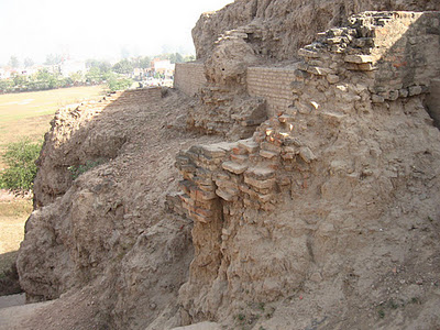 Ropar - The Archaeological Survey of India (ASI) will dig up a site in Ropar, Punjab, where the remains of that old civilisation were first seen in independent India, in 1953, but where excavations stopped in 1955. For some unexplained reason, ASI archaeologist Y.D. Sharma, who carried out that avowedly “limited” exercise, never published a detailed excavation report although he published articles in journals about it. While Ropar (now Rupnagar) lay untouched for 56 years, US archaeologists took a deep interest in the Harappa and Mohenjo-daro sites. Harappa has been under re-excavation since 1986 by J.M. Kenoyer of the University of Wisconsin and Madison. Mohenjo-daro, which cannot be excavated because of its high water-table, has also been extensively studied and investigated by scholars. Ropar, in any case, cannot compete with the highly developed and well-planned cities of Harappa and Mohenjo-daro. Besides, constraints of space will severely limit the excavation’s scope although the ASI has better technological tools compared with the 1950s. “The protected area (in Ropar) is about 12 hectares and there is human settlement outside it. We cannot carry out excavation beyond the protected area,” said superintending archaeologist V.N. Prabhakar, who will be in charge of the Ropar re-excavation. In contrast, the Harappa site is spread over 300 hectares. Archaeologists believe that the Harappans lived at the Ropar site till about 2,000 BC. Why and in what circumstances they left it remains a mystery. After that, the site seems to have remained uninhabited for a considerable time. Towards the end of the second millennium BC, however, another people of a different stock came and settled there.
http://www.telegraphindia.com/1120108/jsp/nation/story_14978527.jsp
EGYPTE – 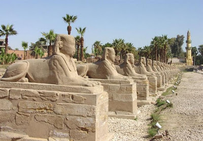 Louxor - The Egyptian Minister of State has recently announced that the ancient Avenue of Sphinxes connecting Luxor and Karnak shall be reintroduced to the public in March. For five years, a project has been under way to restore the once grand Avenue of Sphinxes. In March 2012, it shall conclude and the avenue will be introduced to the world once again. Luxor was once the city of Thebes as well as the city of the god Amon-Ra. In the 15th century B.C. Queen Hatshepsut built six chapels there, dedicated to the god, that became part of the avenue, which was 2.7 km long and featured hundreds of sphinxes. Her aim was to stress the religious status of the city. In the 4th century B.C., Pharaoh Nectanebo I had the avenue reconstructed and rebuilt. For centuries, parts of the avenue have been visible, yet the majority of the stretch has been destroyed or covered in sand.
http://www.tourism-review.com/egypt-to-open-avenue-of-sphinxes-news3064
ESPAGNE – 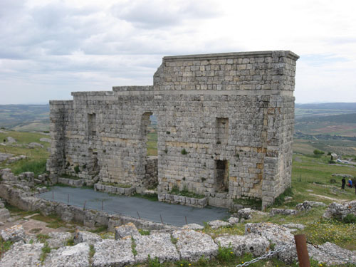 Acinipo - One of Andalucia’s most important archaeological sites, Acinipo in Ronda, has reportedly been the victim of pillaging.Despite the importance of the site, it is very poorly conserved and lacks basic safety measures. It is unclear what the intruders may have taken, but sources close to the investigation claim there are several holes in the area. The plunderers normally hope to find any metal objects, such as coins, jewellery and arrowheads, which can all be found with detectors and sold on the black market.
MEDITERRANEE – 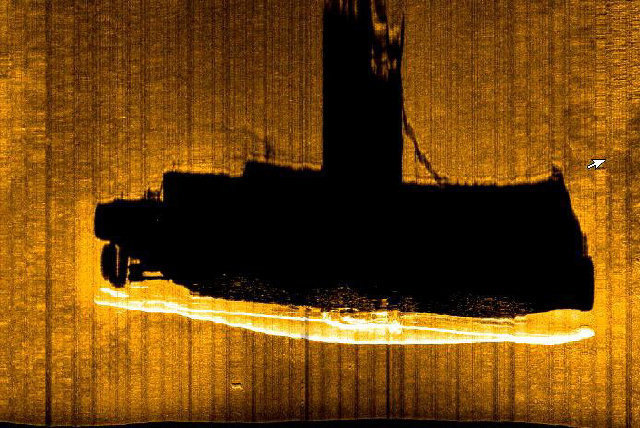 - The Key Largo-based Aurora Trust, a not-for-profit ocean exploration and education foundation, has solved a World War II British mystery. On May 8, 1942, under the cover of darkness, the British submarine HMS Olympus (N35) was attempting to leave the British Naval Base in the Grand Harbor of Malta, a tiny island nation just south of Sicily and north of Tripoli that was blockaded by the Germans and Italians. But the Olympus didn’t get far before striking a mine and sinking. For nearly 70 years, nobody knew exactly where the 283-foot sub’s final resting spot was in the Mediterranean Sea. Only nine of the 98 men aboard survived, swimming about seven miles in cold water and without lights to guide them due to the wartime blackout. A year ago, the marine archaeology survey team from the Aurora Trust discovered the sub using side scan sonar. But at the time, they weren’t sure exactly what the image showed. The team, which operates from Malta, returned a few months later with deep-sea robotic vehicles to videotape the wreck — twice as deep as recreational divers can go.
http://www.miamiherald.com/2012/01/10/2582591/key-largo-divers-discover-sub.html
USA – 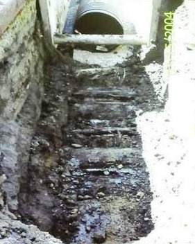 Bucyrus - In September 2009, street crew workers made quite a discovery. Workers digging up the North Sandusky Avenue area near Plymouth Street to lay new sewer lines for the city unearthed what used to be part of the Columbus-Sandusky Turnpike -- a corduroy road made of tree trunks in the early 1800s. Only a small amount was able to be preserved. According to T. Grooms, a charter was created as the brainchild of Col. James Kilbourne to put down a road from Columbus to Sandusky, stretching 106 miles. The charter would apply for grants to help build the road, then charge tolls to travelers. The tolls varied widely. Grooms said a four-wheel cart drawn by two horses or oxen would cost 25 cents, and a two wheel cart led by the same would cost 18 3/4 cents. It was an additional 6 1/4 cents per horse or oxen. "Sometimes the roads weren't always kept up very well, and there were cases of people tearing down the toll booths in protest," Grooms said. "The expectations of the locals were not met when they built this road. It was nearly impassable in rainy and wet conditions." The corduroy roads had their famous detractors as well. Legendary writer Charles Dickens traveled the turnpike and once wrote: "It was made by throwing trunks of trees into a marsh, and leaving them to settle there." Originally there were supposed to be planks to hold the larger portions in place, and some of those pieces also were unearthed. Grooms said the road was finished in 1834, but sometime in the 1840s, the charter was given up and tolls were no longer collected. "What hurt this road was the canal that was put in, and what hurt the canal was the railroad after that," Grooms said. The trees that were used to cover marshy areas in Bucyrus were among the biggest that have been discovered.
USA - St. Augustine - Recent archaeological findings seem to prove that the St. Augustine founded by Don Pedro Menendez in 1565 initiated a struggle for the colony to survive hunger, mutiny, moving three times, hostile Timucuan Indians and the ever-present threat from the French... Some of the most important finds include the Gonzalez sherd, the first indigenous pottery fragment found with a European name etched inside it; ashes at a dig near the Art Association building dating to the 1586 raid by Sir Francis Drake that burned St. Augustine to the ground; and, most recently, finding what appears to be the post holes of an early fort that once stood where the Castillo de San Marcos parking lot is now. “It was a quadrangle structure with a well,” Halbirt said. “What it represents we don’t know. (An early fort from around 1580) is our hypothesis right now,” he said. That may be impossible, because Halbirt’s map shows that much of the rest of that fort may be under busy Castillo Drive.Two of his important finds were a full skeleton of a donkey near the castillo encampment where he believes Timucuans workers lived, and a Civil War-era cellar on the property where the Casa Monica is now. Deagan said Menendez landed in April 1565, but by that October, only 200 of the 800 people he brought here remained. “He sent some of them to several other forts,” she said. Spanish artifacts have also been found at the Mission de Nombre de Dios and La Leche shrine, she said. But she and her graduate students and volunteers focused their archaeological explorations on the Fountain of Youth, where she mapped out the remains of many structures used by Spanish troops. One great building may have been a fortified storehouse 60 feet long and 40 feet wide, she said. “This was the Menendez settlement,” Deagan said. “Archaeology is like putting together a jigsaw puzzle of 1,000 pieces, but without a picture.”
USA – Volcano - After the success of Mountwood Park's archaeological dig of Thornhill Mansion in August, the park will team up with Hocking College again this summer for a second excavation. Last year, the dig focused on the foundation of Stiles Mansion, former home of oil and gas pioneer W.C. Stiles. The mansion was built in 1874 by Stiles, also known as the "Father of Volcano." Included on the estate were flower gardens, orchards, a tennis court, a barn, caretaker's house and a wine, vegetable and fruit cellar. Over the years, the mansion fell into disrepair and the town of Volcano was destroyed by a fire. "We're hoping the dig expands to the caretaker's house this summer," said Naylor. Among the items unearthed last summer were coins, fragments of marble, animal bones, leather, wine bottle fragments and porcelain. In the spring, these artifacts will be returned to the park and put on display.
USA – Provo - Brigham Young University's geology department is helping graduate students and BYU's Office of Public Archaeology learn about what's underneath the park grounds at the Provo Tabernacle using sophisticated ground penetrating radar at the site. The newsletter also notes that "preliminary excavation this past month (November) focused on uncovering the foundation of the southeast corner of Provo's first tabernacle, which lies beneath the grassy park immediately north of the current tabernacle." Not only is the radar grid helping students get a better vision of what's under the surface of the park, but as students excavate, they also are recording and photographing areas of the site.
![]()
INDIana UNIversitas
INSTITUT SUPERIEUR D'ANTHROPOLOGIE
INSTITUTE OF ANTHROPOLOGY
ONLINE COURSES / COURS A DISTANCE
ANTHROPOLOGY / ARCHAEOLOGY
WINTER TERM : JANUARY 2014
REGISTER NOW