
07 AOUT 2018: Sântana - Dawadmi - Tappeh Yazdan - Loches - Meaux -
INSTITUT SUPERIEUR D'ANTHROPOLOGIE
INSTITUTE OF ANTHROPOLOGY
ONLINE COURSES / COURS A DISTANCE
FALL TERM : OCTOBER 2018
REGISTER NOW
ROUMANIE –  Sântana - Archaeologists unearthed in Sântana, a town in Arad county, according to aradon.ro, in Western Romania, a rather big citadel, covering a vast area of 90 hectares, believed to be almost 3,400 years old, dating from the Bronze Age. Archaeologists working at the excavations site have called in "Old Citadel" (Cetatea Veche), and their work began in 2009. However, excavation pace became faster in the past 24 months only to bring the present results. The research's head professors Rüdiger Krause, of the Goethe University in Frankfurt, and Romanian Florin Gogâltan, of the Institute of Archeology and History of Art of the Romanian Academy in Cluj-Napoca, came to the conclusion that the "Old Citadel" in Sântana was built in the 14th century BC, about 3,400 years ago, they said speaking to local aradon.ro. "The citadel in Sântana is one of the largest fortifications built during the mentioned period. Our purpose is to find out why this fortification was made, why this construction was needed", the German expert noted. His Romanian colleague added that "Troy had an area of 29 hectares, the Citadel in Sântana covers 89 hectares. The buildings of Troy were made of stone. At Sântana, the buildings were made of clay and wood, a sign that civilization was more developed and adapted to the building materials it had. We are facing one of the biggest and impressive fortresses in Europe. We researched about 55 hectares of the nearly 90. And, following these measurements, we found something that scared us: a huge palace, with a length of 100 meters and width of 40 meters. We want to continue digging and, if possible, we want to make this citadel great again, just as it was over 3,000 years ago."..
https://www.balkaneu.com/3400-years-vast-old-citadel-discovered-in-western-romania/
ARABIE SAOUDITE –  Dawadmi - Archaeologists confirmed that a Saudi town commonly mentioned in historical documents for hosting ancient gold and silver jewelers was actually an important mining area. Dawadmi, located in the central Riyadh province, is presumed to have been a hub from where mining products were exported 1,200 years ago. The most recent excavations at the site revealed the existence of infrastructure from the early Islamic period, such as a mosque and houses with yards and storage with ovens for metal melting. Other recent findings include glass and ceramic implements, and precision tools such as those for making beads and glass beads. Preliminary results indicate that the artifacts probably date back to the early Umayyad era. Dawadmi is home to more than 35 archaeological sites, most of them showing rock engravings of different kind of animals and historical writings.
http://www.mining.com/saudis-discover-1200-year-old-mining-hub/
IRAN - 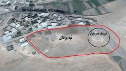 Tappeh Yazdan - The Public Relations Office of the Research Institute of Cultural Heritage and Tourism (RICHT) quoted Nasrin Beig Mohammadi, head of the probing plan to determine the limits and privacy of Tappeh Yazdan in Nahavand, Hamedan Province, as saying on Sunday that Nahavand-Firouzan plain located in the north-south direction in north of Nahavand, is one of the most important plains of Hamedan and Central Zagros in terms of the ecosystem and geomorphology (fertility, rich water resources: rivers and mirages, natural pastures: vegetation and animal cover, etc.) as well as archeological studies. Tappeh Yazdan, with works from the Copper-Stone, Bronze and Iron Age, historic periods up to different Islamic eras, is one of the most important enclosures of the plain which has remained unknown in terms of archeological studies, she noted. The site with its vast rich pottery pieces from different eras of the Bronze Age (especially the Bronze Age cemetery), as well as the Iron Age, has the historical and cultural sequence of Tappeh Gian and Godin hidden in it, she added. Referring to the fact that Tappeh Yazdan has a terrace on its western side which, with a less slope compared to the head of the hill, is used as the treshing floor by the villagers, Mohammadi noted that in this part there are graves belonging to the Bronze Age, three of which have been explored unauthorizedly. This archeologist further referred to the identification of varieties of pottery pieces from the Copper-Stone, Bronze and Iron Age, historic and Islamic eras in the study of the surface and the slopes of Tappeh Yazdan. The pottery include those with red clay covering; gray pottery of Yanik style, beige pottery with sand and gravel temper appropriately baked and beige pottery decorated with wide and narrow strips and horizontal strips, wide strips with wavy lines, etc. Considering such rich works on Tappeh Yazdan and its placement in the margins of the village with different construction activities and its encirclement among agricultural lands and destruction due to the aggression of agricultural lands to its limits and privacy as well as unauthorized explorations in different parts of the hill and its cemetery, the archeologist considered as essential determination of the limits and privacy of the hill as a valuable work. Beig Mohammadi added that in the probing plan to determine the limits and privacy of Tappeh Yazdan in Nahavand, 10 boreholes in 1.5x1 dimensions were excavated around Tappeh Yazdan and as a result its limits and privacy were determined.
http://www.irna.ir/en/News/82992123
FRANCE –  Loches - Deux remparts entouraient la cité royale. C’est la découverte qu’ont faite les archéologues du Service de l’archéologie du conseil départemental d’Indre-et-Loire (Sadil). Et cela grâce aux travaux de dévégétalisation de ces hautes murailles. « On a fait des relevés qui sont en cours de traitement, dit-il. Sur 200 mètres de remparts dévégétalisés à l’est du château, on serait sur un doublement des remparts qui daterait de la fin XII e - début XIIIe siècle. En pleine période de guerre entre Capétiens et Plantagenets, il y a cette phase de renforcement des remparts ». Cette double fortification était constituée d’un mur haut, sur l’éperon rocheux, et d’un mur bas (celui restant actuellement). Entre les deux, un chemin de ronde de 5 mètres de large permettait de circuler. Les archéologues avaient déjà des indices laissant supposer l’existence de cette double fortification, grâce aux fouilles précédentes menées au logis royal. « A l’époque, ils ont aménagé le bas du coteau pour créer des galeries avec des archères, souligne l’archéologue. On le voit déjà au nord-ouest, au niveau de la Porte royale. On aura aussi le même système défensif au sud du château ». Autre élément de fortification à l’étude, la caponnière, élément défensif au niveau des fossés, encore visible au niveau du boulevard Philippe-Auguste. Les archéologues ont là aussi procédé à des relevés par photogrammétrie pour la reconstituer en 3D. La caponnière va ensuite être ensevelie pour assurer sa conservation. Elle avait été découverte à la fin du XIXe siècle - début du XXe siècle. Deux autres caponnières sont connues au pied des remparts, comblées avec les fossés lors de la création du boulevard. La forme architecturale fait penser à l’architecture de type Vauban. « Elle présente des ouvertures de tir pour les premières armes à main. On parle de caponnière moineau, il n’y en a pas beaucoup qui soient bien conservées en France donc cette étude est assez importante », souligne l’archéologue. Selon les premières hypothèses, elle daterait vraisemblablement de 1590. L’enfouir est aussi une nécessité en terme de sécurité et de stabilité du rempart, car cette caponnière représente un vide dans le coteau.
https://www.lanouvellerepublique.fr/loches/pas-un-mais-deux-remparts-autour-de-la-cite-royale
FRANCE – Meaux - Cinq mois. C’est la durée des fouilles archéologiques menées rue Saint-Fiacre à Meaux, juste en face de l’entrée de l’hôpital. Le site comprend des vestiges d’un croisement de deux rues datant du Ier siècle de notre ère. De part et d’autre se trouvaient des habitations et des commerces. « Ces rues semblent assez rapidement abandonnées, vers le lIe siècle. La fouille va peut-être nous permettre de savoir pourquoi », s’étonne Christel Delozanne, archéologue à l’INRAP et responsable d’opération. Ces recherches documenteront le passé antique d’une ville qui ne s’appelait peut-être pas encore Meaux mais était déjà peuplée de Meldes. La ville portait alors le nom de ia(n)tinum (avec ou sans « n ») et s’étendait sur 60 hectares. Le nombre d’habitants est impossible à évaluer. « C’est le plus difficile à estimer, confirme David Couturier, archéologue à l’INRAP. On peut connaître la surface d’une ville mais pas la densité de population pendant l’Antiquité. »