07 AOUT 2012 NEWS: Egypte - Varazze - Belle Isle - Mesa Verde -
INSTITUT SUPERIEUR D'ANTHROPOLOGIE
INSTITUTE OF ANTHROPOLOGY
ONLINE COURSES / COURS A DISTANCE
INSCRIPTION : Année Universitaire 2012/2013
REGISTRATION : Academic Year 2012 / 2013
EGYPTE – 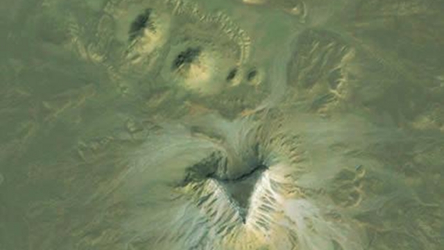
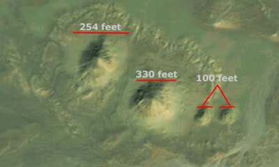 Satellite archaeologist Angela Micol believes she may have stumbled upon two previously unidentified pyramid structures by using Google Earth. Located in Egypt, the sites contain distinct features and orientations that definitely suggest the potential presence of pyramids — a prospect that has local archaeologists eager to check it out. One of the complex sites contains a distinct, four-sided, truncated, pyramidal shape that is approximately 140 feet in width. This site contains three smaller mounds in a very clear formation, similar to the diagonal alignment of the Giza Plateau pyramids. The second possible site contains four mounds with a larger, triangular-shaped plateau. The two larger mounds at this site are approximately 250 feet in width, with two smaller mounds approximately 100 feet in width. This site complex is arranged in a very clear formation with the large plateau, or butte, nearby in a triangular shape with a width of approximately 600 feet. According to Egyptologist and pyramid expert Nabil Selim, these structures have never been identified — and he notes that one of the proposed sites is similar in size to 13th Dynasty Egyptian pyramids. It's anticipated that archaeologists will visit the site to conduct what's called "ground truthing."
http://io9.com/5932429/have-archaeologists-discovered-lost-egyptian-pyramids-using-google-earth
ITALIE – 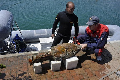 Varazze - Lieutenant-Colonel Francesco Schilardi, the commanding officer of the police team that found the wreck, has been referred to as the ''Top Gun'' of the oceans because of the secrets he and his team unravel by locating and recovering wrecks and long-lost treasures. This time the team, including state archaeologists and historians, were so sure that the ocean, close to the town of Varazze, Liguria, was hiding something special that they went to a little more expense to find out what was down there. They used a submarine, a robot and sophisticated mapping and tracking equipment, along with the results of extensive historical studies of the area. They uncovered a 2000-year-old Roman vessel buried 70-100 metres deep and encased in layers of mud that promises to reveal secrets about the way of life in the 1st century AD, not only in Rome but in other regions that traded with the empire. The discovery of the food transport vessel, with an estimated 200 clay amphorae on board - and with caps of pine and pitch intact - sent ripples of excitement through archaeological communities partly because the ship and its contents are remarkably well preserved. It goes back, he said, to the Roman republican and imperial age, when Rome traded with the Mediterranean countries, primarily Spain, and when the Ligurian Sea and the nerve centre, or the crossroads of Roman marketing and trade at the time.The sea lanes in the area were used by the Romans to export food including honey, spices and wine from the late Roman Republican era to the beginning of the Augustan Age. Lieutenant-Colonel Schilardi was also quoted in the Italian press saying the fact the containers were so well preserved might help to reveal important information about diet at the time and perhaps add to cultural and commercial profiles of the period. The fact the wreck was found at such depth, and encased in a bed of sandy mud that is typical of the area, helped ensure the vessel remained in a good state of preservation, he said.
http://www.theage.com.au/world/sea-gives-up-a-portrait-of-ancient-rome-20120807-23sdr.html
CANADA – 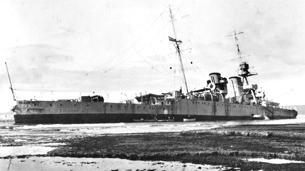 Belle Isle - Divers and archaeologists begin their work Monday documenting the wreckage of a historical British ship that ran aground in a corner of southern Labrador nine decades ago. The remains of HMS Raleigh will be mapped, photographed and recorded during the mission. Wednesday marks 90 years since the battle cruiser ran into a reef off the coast of southern Labrador, on the Strait of Belle Isle that separates the mainland from Newfoundland. The episode is considered one of the biggest blunders in British naval history. At the time, HMS Raleigh was the pride of the Britain's North Atlantic squadron. It was 180 metres in length, heavily armed and had a crew of 700. The ship was a symbol of British sea power. The ship's three-year reign at sea ended during a fishing side-trip on Aug. 8,1922, when the boat blundered onto a reef close to the Labrador coast. Most of the men were saved, but the ship was a total loss. After the incident, local fisherman salvaged what they could from the wreckage, including rum, pianos, furniture and other valuables. Some of the items are still used in the local community. He said the British sent a ship to blow up the remains in 1926, but the entire ship was not destroyed. The group also left behind ammunition. Seven years ago, the Department of National Defence cleared what was visible, but according to diver Roy Mulder, ammunition still poses a risk to divers.
http://www.cbc.ca/news/canada/newfoundland-labrador/story/2012/08/05/nl-diving-to-document-wreckage-805.html
USA – 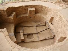 Mesa Verde - Archaeologists at Mesa Verde National Park say a crack is threatening the southern half of the park's largest and most famous cliff dwelling. The park announced Friday that the crack and other related structural problems is the reason why visitors have been kept away from the edge of a kiva on tours of Cliff Palace this summer. Wooden braces are now shoring up the kiva, a round, Pueblo Indian ceremonial structure built in the 13th century. The crack was discovered last summer but it's not the only problem archeologists are working to fix. Cliff Palace was built on a sloping alcove floor and, over time, it has been sliding downslope. Dripping water has been a long-standing problem too but water is now being rerouted away from the building. The National Park Service said a fault line is running parallel to the back of Cliff Palace and is threatening Kiva F and the southern half of Cliff Palace.
http://www.thedenverchannel.com/news/31330453/detail.html