05 AVRIL 2024 NEWS
INSTITUT SUPERIEUR D'ANTHROPOLOGIE
INSTITUT OF ANTHROPOLOGY
COURS ONLINE – COURS A DISTANCE
INSCRIPTIONS OUVERTES
REGISTER NOW
FRANCE – 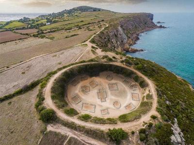 Cap d’Erquy - A major archaeological discovery has just been made at Cap d’Erquy, in the Côtes d’Armor region, France. The ruins of a circular-shaped village dating from the Iron Age have been uncovered using revolutionary satellite imaging technology. The village discovered at Cap d’Erquy consists of around twenty circular huts arranged around a central square. Archaeologists believe that this village was occupied between the 8th and 5th centuries BC by a Gallic community. The area that the ancient Gauls called home included parts of western Germany, northern Italy, and Belgium in addition to present-day France. The Gauls, a Celtic people, were divided into multiple tribes and ruled by a landed class in their agricultural society. The tribes throughout Gaul operated independently from one another and only united in times of crisis. Each tribe had its leaders and their religions. During the Gallic Wars (58–50 BC), Julius Caesar led the Romans in their conquest of Gaul. “This is an exceptional discovery that gives us a better understanding of the daily life of the Gauls during the Iron Age. This technology paves the way for significant new discoveries and allows for the exploration of archaeological sites that were previously inaccessible,” explains Jean-Yves Peskebrel, an archaeologist at INRAE (National Institute for e-realistic Archaeological Research). Developed by INRAE and known as “LiDAR”, this technology uses lasers to scan the ground and create volume reconstructions of unrivalled accuracy. This process makes it possible to detect buried structures that are invisible to the naked eye, without the need for invasive excavations.
Circular-shaped Iron Age Gallic Village discovered in Côtes d'Armor, France - Arkeonews
BULGARIE – 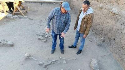
 Sozopol - A medieval necropolis was discovered during excavations at the construction site of a bus station in the old seaside town of Sozopol, 35 km south of Burgas on Bulgaria’s southern Black Sea coast. The layer above it contained two 13th-century lead seals. with images of saints and inscriptions referring to correspondence, most likely between high clergy. Ten burials and reburials have been uncovered south of this site. “As in the modern world, when a close relative dies, he is buried in the grave of a previously deceased family member. There may be a layering of 10-15 burials on top of each other,” explains Yavor Ivanov. So far, during the excavations, they have discovered several skeletons of children, including a baby. Probably buried above one of its parents. Human remains are well-preserved. According to Christian tradition, they face west. The ceramics discovered date from the eleventh to the early thirteenth centuries. Except for coins and ceramics, no grave goods have been discovered thus far. More iron nails were discovered, but there was no evidence of a wooden structure into which they were driven. Burials are in burial pits. A structure made up of small and medium-sized rubble stones is visible south of this sector. Its purpose is unknown, but it could be a deep building or a route to other structures. It will provide a broader overview of the area situated on the isthmus dividing Sozopol’s old and new towns. A single-nave church was opened in front of the municipal building and other burial structures, and studies were conducted there during the 2012–2013 water cycle construction. In the southwest corner was a large pithos, which was occasionally used for funerals in addition to storing cereals. The vessel discovered at the site was empty, but it will be checked for organic remains. Yavor Ivanov states that further burials from the 4th century are anticipated to be discovered at the bottom, in a deeper location, and from the Late Hellenistic period, similar to those discovered nearby during earlier excavations.
IRLANDE –  Inis Mór - It has been reported that the discovered fort may be as important as Dún Aonghasa, the largest of the prehistoric stone forts of the Aran Islands. It is located on Inis Mór, at the edge of a 100-meter-high (330-foot) cliff. Dún Aonghasa (unofficial anglicized version Dún Aengus), a popular tourist destination, is a significant archaeological site. Archaeologist Michael Gibbons told the Irish Independent that initial surveys suggested that the island of Collanmore was a late Bronze Age fort. The discovery of several large ramparts slicing through the tidal isthmus connecting the island to the shoreline outside of Westport provided the first clue. One of the bigger islands in the bay, Collanmore, which is accessible by foot at very low tides, was once a base for the Glenans Irish Sailing Club. The set of double ramparts are faced with large limestone blocks and extending for 200 to 300 meters, and are “most likely to be late Bronze Age in date, dating between 1100-900 BC”, Mr Gibbons said. Both features are covered on high tide, and the site is “so large and coated in seaweed that one can see why it wasn’t discovered before”. The archaeologist said they were lucky that day as there were men cutting seaweed in the same area. A team from Connemara and archaeologists from Mayo County Council were also present. “This outer rampart — as in, the one nearest the mainland — was known to the locals, but they had no idea how old it was or how significant it is. Their size and scale “would suggest that the island was of major strategic importance at the time”. Gibbons stated that similar ramparts can be seen in other coastal and lake promontory forts in the west of Ireland, with the closest examples being found to the north, including a large promontory fort defended by double ramparts north of Newport, Co Mayo, and a massive promontory fort on Lough Fee, located on the northern shores of Carra Lake.“Late Bronze Age hillforts are the largest monuments built in Ireland and can measure up to 320 acres in area, with kilometers of defensive ramparts,” he said. The later part of the Bronze Age (1500-700 BC) was a time of settlement expansion and economic prosperity in Ireland. Hillforts are another manifestation of a warrior culture that emerged not only in Ireland but across Europe during the Middle and Late Bronze Age. “They were built by warlord-dominated societies and we have very good evidence they were in active use during periods of warfare between various tribes,” Gibson added.
Archaeologists discovered a sunken prehistoric fort in Clew Bay island - Arkeonews
IRAN – 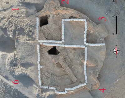
 Tappe Takhchar-Abad - Archaeologists have uncovered an almost circular adobe building with six towers, built in the 6th century BC, near Birjand in South Khorasan. Excavations in the largely unexplored Khorasan began in 2009 and are one of the few excavations that have continued to the present day. In the east of Iran, only two archaeological sites had previously been excavated: Dahane-i Gholaman in Sistan to the south of Khorasan and Tappe Rivi in the north of Khorasan. The site, called Tappe Takhchar-Abad is located near Birjand and on the edge of a barren plain; no contemporaneous and related sites have been identified. Since 2009, there have been four excavation seasons. Tappe Takhchar-Abad sits on a semiconical hill, with a base diameter of 42 meters and a height of 4 meters, around which is a trench about 11 meters wide, with a canal to the northeast that supplied it with water. After four seasons of excavation, the remnants of an almost circular building made of adobe and pisé (Chineh/pakhsa) with a diameter of eighteen meters, six solid towers, and walls as high as three meters were exposed. This building was completely covered and intentionally filled with sand. Additionally, it was indicated by two soundings that this building was filled in two stages.Tests revealed that it was intentionally filled to a height of nearly 2 meters with alternating layers of broken or intact brick, sand, and stones. The archaeologists wrote that the evidence shows that after the building was filled, some structures were built on top of it during the Parthian period. Traditionally, circular sites have been attributed to the Parthian period, but recent evidence suggests that the construction of these buildings began in Greater Khorasan during the Achaemenid period, and that about 10 such sites were first identified and excavated in Bactria, east of Greater Khorasan. The authors were able to divide and date the pottery found at Takhchar Abad into two periods. The Late Iron Age/Achaemenid period (seventh-sixth centuries BC) and the Parthian period (third-fourth centuries AD). In terms of cultural materials, it is difficult to identify Achaemenid sites using surface materials such as pottery because the cultural materials of the Achaemenid period are very similar to those of previous periods. These excavations in south Khorasan are expected to play an important role in the identification of Achaemenid-era buildings and shed new light on the history of this period.
A Circular Building with Six Towers of the Achaemenid Period discovered in Khorasan - Arkeonews
USA - 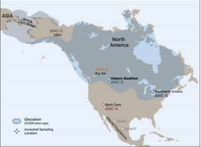 A new study* describes a previously unidentified genetic lineage from which the modern-day Blood (Kainai) First Nation/Blackfoot Confederacy descended. Through comparisons of DNA from both Ancestral and modern-day Confederacy members, the work dates this Historic Blackfoot lineage to the late Pleistocene, corroborating established oral and archaeological records. The Blackfoot Confederacy is made of member tribes with ancestral ties to nomadic bison hunters that lived across the Northwestern Plains and Rocky Mountain Front. Oral and archaeological records place them in this region during the end of the last glaciation by at least 10,000 years ago. Yet, the Blackfoot’s legacy has been contested frequently in land and water rights lawsuits. “The objectives of this study were not only to advance scientific knowledge about Indigenous genomic lineages that can provide insight into the peopling of the Americas but also to provide the Blackfoot with an independent line of evidence for evaluating purported ancestral relationships with other North American groups,” Dorothy First Rider and colleagues write. Here, First Rider et al. analyzed samples from 7 historical Ancestors and 6 living Blackfoot people. They found that ancient and modern DNA had a high proportion of shared alleles, demonstrating genetic continuity over millennia. Further modeling suggests that the Blood/Blackfoot ancient lineage split from other ancestral Indigenous American groups roughly 18,000 years ago. Athabascan and Karitiana then separated from this Historic Blackfoot group 13,000 years ago. Notably, the investigations help answer why Blackfoot language has minimal linguistic overlap with other Algic (or Indigenous North American) languages such as central Algonquian. “Certain elements of Blackfoot are older than proto-Algonquian language and likely were spoken by Indigenous peoples in the aboriginal homelands of the Blackfoot Confederacy,” the authors explain. “This finding changes the traditional anthropological assumption that the Blackfoot language (and, by extension, its speakers) originated in the North American Great Lakes, where Algonquian purportedly evolved.” They add that Historic Blackfoot likely traveled from west to east to end up in the Northwestern Plains.
CHINE – 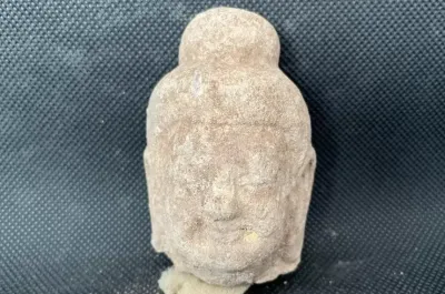 Datong - A Buddhist temple dating back to the Northern Wei Dynasty (386-534) has been unraveled in Pingcheng District, Datong City of north China's Shanxi Province. This was reported by The Xinhua News Agency. Believed to have been an official temple or a royal one, the ancient temple is located some 300 meters from the palace ruins of the Northern Wei Dynasty, with a pagoda as its center, said the provincial institute of archaeology. The researchers found a square pit with pearls, coral jewellery and brass rings in the middle of the pagoda foundation. More than 200 well-preserved Buddhist statues were also unraveled inside the pagoda. Some of the statues were painted while some were gold foil-decorated. "The pagoda is believed to be painted with murals as its peeling wall remains suggest", – said Li Shuyun, deputy head of the institute. "It is the most well-preserved pagoda foundation remains that Datong has ever discovered, providing important physical research materials for the study on architectural forms of Buddhist pagodas at that time", – Li added.
Ancient Buddhist temple found in north China | Ukrainian news (ukranews.com)
FRANCE – 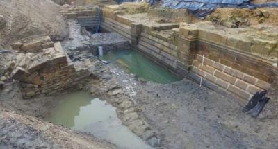 Vannes - The stunningly well-preserved remains of a castle have been dug up in the French city of Vannes, Brittany, at the foot of a private hotel. The first phase of the project took place between February and April 2023 in the cellars and courtyard of the hotel which was originally a private mansion built at the end of the eighteenth century. The courtyard had been built atop an embankment 13 feet deep (4 meters). Down below, archaeologists unearthed two stories of what was probably a four-story castle that measured 140 feet long and 55 feet wide overall. Connected to additional defensive elements, it would have been even larger. Historical records all but confirm the castle was Château de l’Hermine, constructed by the Duke of Brittany in 1380 following the end of one of the many wars between French royals. It was part of a large public works program that doubled the size of the city of Vannes, but was abandoned by the Duchy in favor of Nantes in 1470, before becoming ruins in the 17th century. A central passage connects the north gate, built into the façade on the city side, to another gate framed by two large towers that once made up a section of the city rampart overlooking the outer moat, all of which was identified on very old architectural plans of the city. They unearthed several staircases, including a remarkably well-preserved ceremonial staircase with a decorated core, several intact steps, and a sitting window. In the skeleton of the exterior masonry at each end of the house, the archaeologists also identified a set of latrines and drainage pipes that served the upper two floors. Also identified were the foundations of a watermill, placed “in a very original way” at the corner of the castle near a square tower. A canal brought water from the River Marle to drive the mill. The water drained to the moat downstream of the wheel through an opening in the façade, the grille of which has been preserved. Across all the recovered masonry, the stones have been remarkably well maintained by the embrace of the wet earth, and in some places appear to have been laid recently. The drain pipes and latrines were searched manually, but thanks to 580 years of passing time the workers had only soil and water to dig through. They also performed a deep bore into the former moat, and the two searches yielded hundreds of varied artifacts. Cooking utensils, pots, pans, and wooden crockery, jewelry, a selection of coins, padlocks, remains of furniture like cabinets and chairs, keys, pins, clothing fragments, remains of the watermill, shoe buckles, and graffiti-covered ceramic tiles were all found.
ISRAEL - Upper Galilee - a new study suggests that hominins who lived in what is now the Upper Galilee used local quarries to make tools for hunting and butchering elephants that visited nearby water sources between about two million and 500,000 years ago. Meir Finkel of Tel Aviv University said that elephants follow the same routes to reliable water sources because they each consume more than 100 gallons of it daily. Finkel and his colleagues examined such migration routes used by ancient elephants, based upon the landscape of the Upper Galilee and fossils analyzed in an earlier study, and determined that they corresponded with local hominin quarries. These quarries were also within walking distance of several Paleolithic sites, the researchers noted. But killing, butchering, and preserving such a large animal is a dangerous undertaking that draws other predators. The job would have had to have been completed quickly. Large quantities of suitable cutting tools would have been prepared in advance of the hunt, explained Ran Barkai of Tel Aviv University. “It was tradition: For hundreds of thousands of years, the elephants wandered along the same route, while humans produced stone tools nearby,” he concluded. Read the original scholarly article about this research in Archaeologies.
Hominins Quarried Stone Near Animal Migration Routes - Archaeology Magazine
ANGLETERRE – 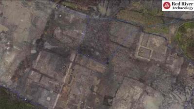
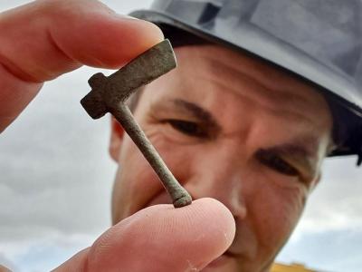
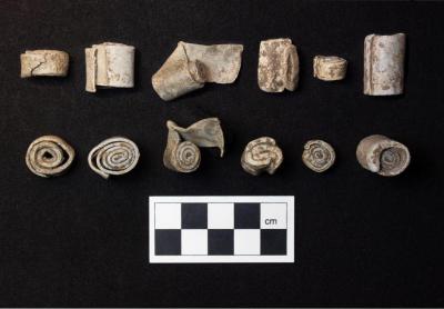 Grove - Archaeologists have uncovered a “richly decorated” remarkable Roman villa complex during excavations at Brookside Meadows in Grove, a village in Oxfordshire, England. The complex evolved and included several buildings from the late first and second centuries, as well as four enormous columns or post bases, which were among the largest from the Roman era in Britain. The villa complex, discovered in a landscape dating back to the Bronze Age, is adorned with intricately painted plaster and mosaics. Among the discoveries are fragments of a monumental hall-like structure known as an “aisled building,” with hints of internal colonnades. The site also contained strange artifacts, such as miniature axes and scrolls, which could have once been used in rituals. “The sheer size of the buildings that still survive and the richness of goods recovered suggest this was a dominant feature in the locality if not the wider landscape,” says Louis Stafford, a senior project manager at Red River Archaeology Group (RRAG), in the statement. The villa had a central hall that served as a link between several rooms. Site director Francesca Giarelli tells CNN that it was probably constructed before the adjacent aisle buildings, which were larger constructions that might have been added as the owners’ wealth increased. One of the complex’s buildings likely had multiple levels. The artifacts found depict a vivid picture of Roman life, ranging from sophisticated painted plaster with floral motifs to mosaic tesserae, hypocaust box flue tiles, and a plethora of coins, rings, and brooches. A horse-headed belt buckle from 350-450 C.E. provides insight into late Roman and early Anglo-Saxon interactions, highlighting the site’s historical significance. The artifacts suggest that Romans occupied the area through the fourth or fifth century C.E. Villas were more than just places to live during the Roman Empire’s rule in Britain, which lasted from 43 to roughly 411 C.E., Giarelli tells CNN. Villa owners were frequently in charge of keeping up with crops, repairing roads, and stockpiling food. The villa also included repurposed areas, such as an oven made of melted Roman building material that was used to dry cereals and hops. This is a reflection of a phenomenon seen in other opulent Romano-British villa complexes, where function was prioritized over ostentatious displays of wealth as agricultural processing and manufacturing became more important. One of the site’s most fascinating discoveries is a group of lead scrolls that are tightly wound and resemble Roman “curse tablets.” Curse tablets, written by someone begging the gods to hex an enemy, were frequently rolled, folded, or punctured with a nail. These scrolls, though blank at the moment, hint at a possible ritual or pilgrimage site within the estate, as do the small votive axes.