02 JUIN 2014 NEWS: Blois - Newark - Newton - Gökçeada - Tachachit -
INSTITUT SUPERIEUR D'ANTHROPOLOGIE
INSTITUTE OF ANTHROPOLOGY
ONLINE COURSES / COURS A DISTANCE
SUMMER TERM : JULY 2014
REGISTER NOW
FRANCE-  Blois - Une fouille archéologique est en cours sur le site de l’ancien hôpital psychiatrique en Vienne. Elle doit se terminer en juin. La fouille menée depuis octobre 2013 a mis au jour des vestiges dignes d'un grand intérêt. Prescrites par l'État (Drac entre autres), les fouilles couvrent 12.000 m2. Les dépôts archéologiques, qui en certains points atteignent jusqu'à 3 mètres d'épaisseur, ont permis des découvertes qui donnent une explication des origines de la ville. Les sept archéologues qui interviennent sur le chantier ont ainsi découvert une tombe isolée prouvant l'occupation de ce site entre le IIIe et le Ier siècle avant Jésus-Christ. « Mais ce n'est alors qu'un lieu de passage. La ville de Blois s'est créée à l'Antiquité lorsque l'empereur Auguste initie l'urbanisation en Gaule. Grâce au chantier en Vienne, on sait désormais que la ville se développe en parallèle de la rive droite sur la rive gauche, et ce, dès sa création », explique Didier Jousset. Les parcelles situées rue du Puits-Neuf sont alors totalement occupées par des habitants qui s'installent sur les traces de leurs ancêtres gaulois. L'espace est partagé en enclos et en lieux différents. L'un de ces endroits délimite un sanctuaire gallo-romain, identifié par un fanum gallo-romain (temple à plan carré de tradition celtique). Des ex-voto, des monnaies jetées sur un emplacement aux abords du temple, des dépôts atypiques de céramiques brisées dans un fossé et des vases posés à l'envers sont autant de preuve d'une activité cultuelle. Le site comporte, à l'est et au nord, des traces d'habitations qui se concentrent le long des axes de circulation, dont un traverse le site. Un grand édifice interroge sur la présence éventuelle de commerces, et le cœur du site a livré la présence de celliers et de séchoirs indiquant la limite méridionale de l'agglomération.
Puis, au fil des siècles, les parcelles en Vienne sont de moins en moins occupées. Enfin, entre1680 et 1691, les parcelles sont majoritairement acquises par l'hôpital général.
ROYAUME UNI –  Newark - They were among the bloodiest sieges in the English Civil War, and left a third of its population dead. Now archaeologists are hoping to uncover more about them as part of a laser archaeology project in Newark. Archaeologists from the new English Civil War Centre and Sheffield University are about to embark on a laser mapping project that could help find the 17th century siege works from the bloody conflict that engulfed the Royalist stronghold. Surviving trenches, forts and redoubts in the Nottinghamshire market town are said to be the best of their kind anywhere in the UK. They date from the time when Newark was attacked by Parliamentary and Scottish forces, leading to some historians to dub the town, the Stalingrad of the English Civil War. Today there are twelve earthworks that are scheduled monuments in Newark dating to the 17th century conflict - including the star-shaped Queen's Sconce, which still stands over 12 feet high and once provided a platform for Royalist canons to blast the besieging forces of the Parliamentary armies.
ROYAUME UNI – Newton -Time Team-style excavations were today starting along a stretch of the Shropshire Union Canal as part of a dig by archaeologists hoping to find evidence and artefacts from the Iron Age. Experts were alerted to the potential for ancient finds on land at Newton, near Ellesmere, by aerial pictures which showed crop patterns on the field typical of those that have archaeological remains beneath the ground surface. Tom Hayek, programme manager for the Meres and Mosses Landscape Partnership Scheme, said: “It’s really exciting for us. We run projects every year, and this is one of those highlights that we look forward to.“We’ve known about the site for some time now and it has been one we’ve been waiting to get started on for a long while. “The site itself could hold a lot of things. It’s not certain what’s beneath the ground but it should show us what the area was used for. “It could be anything from an agricultural enclosure, to a hill fort, but hopefully it will tell us what human activity was there.” The site, between Ellesmere and Colemere, is surrounded by an area rich in history, and experts believe there is a good chance they will uncover objects from the Iron Age, which dates back to around 1,200 BC. The age is characterised by certain forms of implements, weapons, pottery and particular systems of decorative design.
http://www.shropshirestar.com/news/2014/06/02/volunteers-to-help-dig-up-items-from-the-iron-age/
TURQUIE – 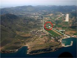
 Gökçeada- Archaeological work on the island of Gökçeada has revealed that an earthquake occurred in the region 4,700 years ago, followed by a tsunami. Çanakkale Onsekiz Mart University Geology Department Professor Doğan Perinçek said they had found the traces of the earthquake and tsunami during works between 2006 and 2008. He said both he and Professor Halime Hüryılmaz had found traces of an earthquake that occurred in 2680 B.C. following work in the area of Yenibademli.“The earthquake broke the walls of the settlements. There is also data that it created a tsunami. We have found the sediments of a tsunami in the region as well as a layer of earth of sand including fossils of sea creatures. Ceramics that were found right below the tsunami sediments date back to 2680 B.C. This is why the earthquake and tsunami occurred before this date, which means it was 4,700 years ago,” he said. “Tsunami waves hit the lower coasts. Yenibademli partly or totally remained under water because of the tsunami. The district was abandoned by locals but they returned sometime later,” he added.Perinçek said Gökçeada was located right next to the Northern Anatolia fault line. Information about some earthquakes can be seen in some historical documents, but the temblor to hit the island almost 5,000 years ago was not recorded, he said. “The only record is the geological traces that we can observe here. Since Gökçeada is located next to the fault line, it is natural that earthquakes occur in the region,” he said.
ALGERIE – 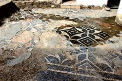 Tachachit - Le site archéologique Tachachit, sis au niveau de la commune d’El Adjiba, sise à 30 km à l’est de Bouira est à l’abandon. Sur une superficie qui s’étend sur 45 hectares, les lieux regorgent de vestiges. Les fragments de poterie, des colonnes et des débris de murs sont visibles partout sur la colline de Tachachit. Toute une ville enfouie sous terre, témoin d’un passé riche. L’âge des ruines trouvées sur les lieux est situé entre le 3ème et le 1er siècle avant JC. Après de grands efforts et multiples appels, notamment de l’association culturelle Les amis de Salah Saadaoui, le site a été classé comme site de wilaya en 2009.Le terrain du site est réparti entre quatre grandes familles, à l’instar de la famille des Ighoumass. Dans le modeste logement de M’hamed Remaci, issu de la famille Ighoumass, une très belle mosaïque romaine avec des motifs berbères couvre la cour. M’hamed a tout fait pour la protéger. La présence de ces mosaïques conforte l’idée que Tachachit était une cité, et non pas un simple poste avancé ou fort romain. Les hypothèses ne sont pas encore confirmées à cause du peu d’intérêt que l’on a consacré au site de Tachachit