
01 SEPTEMBRE 2015 NEWS: Elaussia Sebaste - Sambalpur - Bear River - Atia - Moyen Orient - Fen Drayton - Tsöpki - Didim -
INSTITUT SUPERIEUR D'ANTHROPOLOGIE
INSTITUTE OF ANTHROPOLOGY
ONLINE COURSES / COURS A DISTANCE
FALL TERM : OCTOBER 2015
REGISTER NOW
TURQUIE –  Elaussia Sebaste - New excavation works will start at the ancient city of Elaussia Sebaste in the southern province of Mersin, which houses a necropolis, ancient theater and cistern as well as several aqueducts, on Sept. 8. A total of 45 people will take part in the new excavation on the site, said the head of the excavation, Prof. Annalisa Polosa from Rome’s La Sapienza University. Polosa said she had taken part in excavations at the site since 2002 and she is happy to be the new head, replacing former chief Prof. Evgenia Egnini Schneider, who had occupied the post for the last 10 years. “Excavations have been held in the ancient city for the last 20 years. With the existence of highly valuable cultural assets in the site, the whole area is like an open archeology museum. We have unearthed an ancient theater, agora, basilica, temple and Byzantine palace as well as a number of ancient bathrooms and two ports. We believe more will follow,” she said. She noted a 5 km-long ancient Roman road, which goes through the Ayaş neighborhood to the Korykos Castle, will be opened. Polosa noted that the new excavation will be completed on Oct. 20.
INDE – Sambalpur - Renovation of historical watch towers, which were constructed here in 16th century during the reign of Chouhan dynasty, has finally been started by the State Archaeology wing. The towers were erected on a fort wall which was constructed during the Chouhan rule to protect Sambalpur estate from the enemies. The wall stretched from Balibandha to Mandlia along river Mahanadi. The length of the wall was 2,443 feet. Its construction was started during the rule of king Balaram Dev and completed during the rule of his grandson king Balabhadra Dev in 1594. While the fort wall has already collapsed, the watch towers are in dilapidated condition. There are five dilapidated watch towers each measuring 17 feet in height and 72 feet in width with cannons put up on the top.
http://www.newindianexpress.com/states/odisha/Renovation-Work-of-Chouhan-Dynasty-Watch-Towers-Begins/2015/08/31/article3002316.ece
USA –  Bear River - When Col. Patrick Connor led a group of U.S. calverymen in a daytime attack on the Shoshone in Idaho, at least 250 men, women and children were killed. The events of that bitter cold January morning in 1863 are referred to as the Bear River Massacre, and although it was the largest Native American massacre in U.S. history, few people know the story. For years, the exact location of the massacre was lost — but now, more than 150 years later, archaeologists are searching for the site, hoping to better document the event and educate the public about its significance. Fifteen decades have changed southeastern Idaho: farming, irrigation and natural processes have altered the land, even diverting the course of the Bear River and one of its tributaries, Battle Creek. Part of the archaeologists’ goal is to locate where the Bear River and Battle Creek originally flowed, then use the information to find key massacre sites, such as the Shoshone village, initial assault and fleeing of tribe members. A magnetic gradiometer, a tool that measures magnetic differences beneath the surface, revealed a heavy, black, square signature in the area. “The size and shape of it is pretty suggestive of what a house floor might look like,” Molly Cannon said. The archaeologists suspect the mark may indicate the location of the old Shoshone village. The village likely has the “biggest archaeological signature” of the Bear River Massacre sites, Molly Cannon said, which makes it a natural place to start the excavation. “The area we are most interested in is trying to find out where the village was,” Ken Cannon said. “If we can identify where the village was, we can work back from that.” Although the image suggests a house floor might be buried beneath the surface, the archaeologists can’t be certain until they excavate, she said. “With geophysics all we’ve got are images. It just looks like shades of white and gray,” Molly Cannon said. “We can see patterns, but we won’t know what they are until we excavate them.” Ground-penetrating radar and metal detection results also revealed the area as a point of interest, she said. The dark print is the most “interesting” of the geophysical results, Molly Cannon said, and USU Archaeological Services plans to take a small group to the site to excavate in October. Results of the excavation, Reid said, will be made public in November or December.
BANGLADESH –  Atia - A 406-year-old mosque in Bangladesh that is at risk of demolition is suffering from neglect by the authorities, despite archeologists' repeated warns of losing the historical site. “It's our heritage,” Mohammad Babuluzzaman, current chairman of Atia union parishad, told the Daily Satr on Friday, August 28. Babuluzzaman was taking about the centuries-old Atia mosque which was built on the bank of the Louhajang River in Tangail's Delduar upazila in 1609 as a gift by the Mughal emperor Jahangir. Located adjacent to the shrine of Hazrat Shahan Shah who came from Kashmir to Atia in about 1508 along with 49 followers to preach Islam in the region, the archaeological site has a national significance. Reflecting the beauty of the Bengali art, the nine-foot walls of the mosque is decorated with terracotta plaques. Nowadays, most of the colorful plaques are fading and losing their paints, while others are damaged.
http://en.abna24.com/service/east-asia/archive/2015/08/29/708185/story.html
MOYEN ORIENT –  - Archaeologists have launched a hi-tech initiative to combat the destruction of ancient sites in the Middle East by Islamic State. Scientists at Oxford and Harvard universities said they plan to "flood" the region with 3D cameras in order to catalogue buildings and artefacts of historical significance, preserving knowledge of them should they be obliterated. It comes amid the systematic demolition of the Syrian city of
Palmyra - a Unesco World Heritage site - by the terror group's militants, including the 2,000-year-old temple of Baalshamin. IS, also known as Isis, are destroying ancient relics claiming they promote idolatry, though the extremists are also believed to have sold off looted artefacts. The Million Image Database Project, a collaboration between the Oxford-based Institute for Digital Archaeology (IDA) and Unesco, will distribute 5,000 cameras to war zones by the end of this year, capturing one million images by the end of 2016. A description of the project on the IDA website said: "W e hope to capture one million 3D images of at-risk objects by the end of 2016. To that end, we have created a heavily modified version of an inexpensive consumer 3D camera that will permit inexperienced users to capture archival-quality scans. "This project is the first of its kind in both purpose and scale. However, it is our hope that it will become a model for future similar endeavours. All of the associated technology and software will be open-source to facilitate that goal."
- Archaeologists have launched a hi-tech initiative to combat the destruction of ancient sites in the Middle East by Islamic State. Scientists at Oxford and Harvard universities said they plan to "flood" the region with 3D cameras in order to catalogue buildings and artefacts of historical significance, preserving knowledge of them should they be obliterated. It comes amid the systematic demolition of the Syrian city of
Palmyra - a Unesco World Heritage site - by the terror group's militants, including the 2,000-year-old temple of Baalshamin. IS, also known as Isis, are destroying ancient relics claiming they promote idolatry, though the extremists are also believed to have sold off looted artefacts. The Million Image Database Project, a collaboration between the Oxford-based Institute for Digital Archaeology (IDA) and Unesco, will distribute 5,000 cameras to war zones by the end of this year, capturing one million images by the end of 2016. A description of the project on the IDA website said: "W e hope to capture one million 3D images of at-risk objects by the end of 2016. To that end, we have created a heavily modified version of an inexpensive consumer 3D camera that will permit inexperienced users to capture archival-quality scans. "This project is the first of its kind in both purpose and scale. However, it is our hope that it will become a model for future similar endeavours. All of the associated technology and software will be open-source to facilitate that goal."
ROYAUME UNI –  Fen Drayton Lakes - Long hidden beneath the ground at a Cambridgeshire nature reserve, a lost Roman Villa is set to return to the fore on Saturday. The 1,660-year-old stone structure was first discovered by Cambridge University archaeologists in the early 1990s, but following further excavations, is set to be shown off to the public for the first time. Measuring approximately 50 square metres, the villa, at the RSPB reserve at Fen Drayton Lakes was home to a wealthy Roman settlement, prompting experts to reassess their view of the region as a 'fen backwater'. Christopher Evans, director of the Cambridge Archaeological Unit (CAU), led the project examining the villa. He told the News: “It's a series of corridor-linked rooms with one site suggesting a bath house. "We are also getting building stone which is very rare in our area, because there is no stone here, so everything is imported. There's no doubt we are dealing with a very high value building." It is believed the building stone was imported from Lincolnshire, possibly along the Roman canal system, while glass, pottery and tile fragments suggest the building was inhabited by a high-profile figure of the late Roman period. The excavation has had particular relevance for the RSPB, with archaeological evidence also shedding light on the birds commonly found in the area at the time. Fragments of bird bones recovered from sacrifices have demonstrated how the area teemed with life, with cranes, bitterns, marsh harriers, eels and even Dalmatian pelicans – a bird even larger than a swan that once bred in Britain – all found in abundance.
USA –  Tsöpki - Archaeology students are using 3D technology to make an historic record of a deteriorating pueblo known as Tsöpki, or Antelope House. Northern Arizona University professor Chris Downum says terrestrial photogrammetry is a new trend in archaeology that stitches together hundreds of high-resolution digital images to create a virtual model.Terrestrial photogrammetry also helps Downum and his students estimate the amount of materials they need to preserve the Sinaguan site near Wupatki National Monument. They can see where Tsöpki's 900-year-old mud and stone walls are crumbling and where water can be rerouted to slow erosion.
http://knau.org/post/brain-food-3d-archaeology-helps-preserve-historic-record-ts-pki-pueblo#stream/0
TURQUIE – 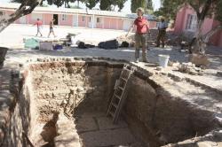 Didim - Excavation works in the Temple of Apollo in the western province of Aydın’s Didim district have unearthed the foundations of a giant structure, thought to have connections with the temple. The works have been carried out by the German Halle Martin Luther University, the German Archaeology Institute and the Milet Museum Directorate. Speaking about the works, head of the excavations Professor Helga Bumke stated the Temple of Apollo extended in to three different spots. “One of them is the excavation area in the garden of a school. The second is the area of an old church, which is currently a mosque, and the third is the area of a modern street passing through the temple,” she said. She said that they were working in the garden of the mosque, and discovered a huge structure there. “The new structure is two meters in width and most probably has a connection with the Temple of Apollo. We can say that it is a temple because we see a very typical temple plan here. Actually, there is no single temple in a holy area. For example, there is more than one temple in Greek holy areas. We know it from the inscriptions. This structure is most probably an extension of the Temple of Apollo,” Bumke said.