01 AOÛT 2020 NEWS
ONLINE COURSES / COURS A DISTANCE
AUTUMN TERM : OCTOBER 2020
REGISTER NOW
ISRAEL – 
 Kfar Kama - Remains of a 6th century church compound — possibly a monastery — were uncovered during an Israel Antiquities Authority salvage excavation in the Galilee town of Kfar Kama. The location, adjacent to Mount Tabor, is sacred to Christians, who since the early Byzantine era have identified the area as the site of the New Testament account of the transfiguration of Jesus. Based on the excavation’s findings, the IAA researchers and Prof. Moti Aviam of the Kinneret Academic College believe the church compound was likely a monastery that was built on the outskirts of the ancient village. Another 6th century church, dedicated to the female St. Thecla, was previously excavated in Kfar Kama in the 1960s. While a saint’s reliquary was also discovered during the current dig, archaeologists have yet to uncover which saint’s bones were once stored in the small stone box. Likewise, no inscriptions or coins were found at the site to aid in dating and identification. Upon further investigation, the archaeologists headed by Nurit Feig discovered that the church had three apses — similarly to approximately half the churches of the area, said Aviam — and that the compound included a large courtyard, a narthex or antechamber foyer, and a central hall. According to the IAA press release, there are additional, as yet unexcavated rooms at the site that were identified during a ground-penetrating radar survey that was conducted by the IAA’s Dr. Shani Libbi. During excavations of the church remains, the archaeologists unearthed pieces of colorful floor mosaics depicting geometric shapes, and blue, black, and red floral patterns. Based on the pottery typography, this church was built in the 6th century and abandoned in the 7th. Aviam said the building boom of Galilee churches was in the 6th century, but there are a few earlier examples, such as a Nazareth chapel dating to the 4th century and a few others dating to the late 4th and beginning of the 5th century.
ROYAUME UNI – Burscough - The site of a first-century A.D. Roman fort in northwestern England has received official recognition from Historic England, a government body dedicated to historic preservation. Aerial photos and both geophysical and lidar surveys have revealed clear traces of earthworks at the site, as well as a gateway with double gate towers and traces of a Roman-era road approaching the fort from the south and east. Excavations lead by archaeologist Stephen Baldwin of The Fort in the Wood Project have also revealed a large stone building within the fort that researchers believe is a Roman granary. Historic England’s recognition means that it is now a criminal offense to damage the site.
https://www.lancs.live/news/lancashire-news/new-roman-fort-uncovered-lancashire-18681252
ISRAEL – Arsuf - On September 7, 1191, Christian forces led by Richard I of England, celebrated as "The Lionheart," defeated the troops of An-Nasir Salah ad-Din Yusuf ibn Ayyub, better known as Saladin, in the Battle of Arsuf. While the confrontation represents one of the most famous events of the Third Crusade, the memory of its exact location had been long lost. Or so it seemed until Israeli archaeologist Dr. Rafael Lewis, using a combination of historical records, archaeological sources and innovative techniques, managed to pinpoint a specific area between Herzliyya, Kibbutz Shefayim and the villages of Rishpon, Kfar Shmaryahu, modern Arsuf and Arsuf-Kedem, as he explained in a recent paper in the Monographic Series published by the Tel Aviv University Sonia and Marco Nadler Institute of Archaeology. Lewis conducted an archaeological survey on a very limited portion of the area using a metal detector. The process uncovered several artifacts in the shallow ground compatible with the material culture from the period of the Crusades, including two arrowheads and a horseshoe dating back to the end of the 12th or beginning of 13th century.
POLOGNE –  Olsztyn - The castle built in Olsztyn (near Częstochowa) in the 14th century was one of the biggest buildings of its type located in that area. The fortress is situated on different altitudes of a large hill. In the area of the lower castle there is a large cave, where the archaeologists are currently conducting excavations. The findings from previous years show that it served not only as a castle pantry, but also, in prehistoric times, as a shelter for Neandertals, whose stone tools were discovered on site. "We performed a series of endoscopic drillings and soundings and detected the presence of rock voids with specimens of endemic insects at a depth of over 7 metres under the bottom of the cave", said the geologist Andrzej Tyc from the Institute of Earth Sciences of the University of Silesia. It turned out that what researchers had previously believed to be the bottom of the cave was in fact hardened sediments full of huge crevices beneath.
https://polandin.com/49201836/prehistoric-underworld-discovered-beneath-olsztyn-castle
ROYAUME UNI – 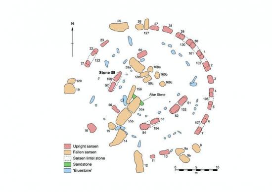 Stonehenge - Interdisciplinary team, including researchers from four UK universities (Brighton, Bournemouth, Reading and UCL) and English Heritage, has used a novel geochemical approach to examine the large “sarsen” stones at Stonehenge. Results confirm that the nearby Marlborough Downs were the source region for the sarsens, but also pinpoint a specific area as the most likely place from where the stones were obtained. Two main types of stone are present at Stonehenge: sarsen sandstone for the massive framework of upright stones capped by horizontal lintels; and a mix of igneous rocks and sandstones collectively known as “bluestones” for the smaller elements within the central area. Research in the last decade has confirmed that the igneous bluestones were brought to Stonehenge from the Preseli Hills in Pembrokeshire, over 200km to the west. The sandstones have been tracked to eastern Wales although the exact outcrops have yet to be found. However, the origins of the sarsen stones has, until now, remained a mystery. Stonehenge is a complicated and long-lived monument constructed in five main phases. The earliest, dated to about 3000BC, comprised a roughly 100m-diameter circular enclosure bounded by a bank and external ditch. Inside were various stone and timber structures, and numerous cremation burials. The sarsen structures visible today were erected around 2500BC and comprised five trilithons (the doorway-like structures formed from two uprights joined by a lintel) surrounded by a circle of a further 30 uprights linked by lintels. research has identified what might be termed the “geochemical fingerprint” of the Stonehenge sarsens. We started by analysing the geochemistry of all 52 remaining sarsens at Stonehenge (28 of those originally present are now missing, having been removed long ago). Analysis of the PXRF data showed that the geochemistry of most of the stones at Stonehenge was highly consistent, and only two sarsens (stones 26 and 160) had a statistically different chemical signature. This was an interesting result as it suggested we were looking for a single main source. Comparing the geochemical signature from Stone 58 against our resulting data revealed only one direct chemical match: the area known as West Woods to the south-west of Marlborough. We could therefore conclude that most of the Stonehenge sarsens were from West Woods. Now these can be revisited as we better appreciate the effort of moving boulders as long as 9m and weighing over 30 tonnes some 25km across the undulating landscape of Salisbury Plain.
INDE – Nauni - A farmer in Nauni village of Jagner block, 70 km from Agra city, stumbled upon the relics of an 11th century Pratihara-era temple while he was digging a fish pond in his field.
EGYPTE –  Mit Rahina – A team of archaeologists from Egypt's Ministry of Antiquities conducting rescue excavations on private land south of Cairo have uncovered black and pink granite statues and carved blocks dating to the reign of Ramesses II (r. ca. 1279–1213 B.C.). The finds include statues of the god Ptah, the lion-headed goddess Sekhmet, and Hathor, the goddess of beauty and love who was also regarded by the ancient Egyptians as the symbolic mother of the pharaohs. Another sculpture depicts the pharaoh himself alongside two deities. Mostafa Waziri of the Supreme Council of Antiquities said that carved limestone blocks dating to the Coptic period indicate later reuse of the site. Excavations will continue until the area has been surveyed entirely.
FRANCE –  Bridiers - Le site de Bridiers à La Souterraine (Creuse) fait l'objet de recherches archéologiques plus ou moins poussées depuis le 19ème siècle. Située, à 50 centimètres sous terre, le site est exceptionnellement conservé, mais garde malgré tout, de nombreux secrets. Dévoiler et préserver une cité antique (datée entre le 1er au 3ème siècle) est généralement mission impossible : bien souvent, des bâtiments plus récents, médiévaux ou modernes les recouvrent. Ce n'est pas le cas ici où les hauts des murs antiques sont très proches de nous, à peine 50cm de profondeur. Depuis plusieurs étés, des campagnes de fouilles sont organisées mais le site est vaste : il pourrait s'étendre sur la bagatelle de trois hectares. Florian Baret, le responsable de ces fouilles l'assure : "Nous apercevons une rue principale bordée de plusieurs bâtiments." Les fouilles se sont concentrées sur le grand bâtiment qui selon les hypothèses pourrait être un atelier d'artisan ou encore un lieu de culte. Le problème, c'est qu'en plus des murs, des sols bétonnés à la chaux et des seuils de porte, les éléments récoltés sont minces. Pour mettre au jour d'autres trésors, les archéologues ont creusé un trou plus profond et sont tombés "malheureusement et heureusement" à la fois sur un puits. "C'est très intéressant car sur le mètre que nous avons creusé, nous voyons que le puits est intact et qu'il a été comblé simplement par l'écroulement de l'habitation juste à côté." Et Florian Baret d'ajouter : "dans ce puits, on trouvera sans doute des vestiges antiques comme des cruches cassées au moment où l'on allait chercher de l'eau." D'après lui, le lieu a pu aussi servir de dépotoir, "et dans ce cas nous pourrions analyser tous les déchets antiques."
ITALIE – 
 Pompéi - Les fouilles continuent de révéler d’innombrables trésors bien enfouis et les nouvelles découvertes sont le fruit d’un travail considérable dans une petite zone, la région V, qui permet désormais de mieux comprendre les derniers jours de la ville dévastée. En plus des fouilles exhaustives menées dans la maison au jardin et la maison d’Orion, des fresques, des peintures murales, des mosaïques représentant des figures mythologiques aux couleurs extraordinaires, des squelettes qui racontent des histoires, des pièces de monnaie, des amulettes et des chevaux de course dans l’étable d’un riche propriétaire foncier furent déterrés. Ces nouvelles trouvailles relancent le débat sur l’histoire tragique de Pompéi. Avant l’éruption du Vésuve qui ensevelit la ville sous une pluie de cendres et de pierres en 79 après J.-C., un travailleur griffonna quelques mots sur un mur. « Il s’est bâfré », peut-on lire. Une inscription drôle qu’il prit cependant soin de dater : le 17 octobre. Ce graffiti vint donc valider l’hypothèse d’une éruption plus tardive, survenue en octobre et non en août comme l’affirment certains historiens.