ARCHEOLOG-HOME / INDIana-UNIversitas
Contact


Exmoor (G-B): Aerial survey uncovers 2,000 archaeological sites
Martin Hesp

The remains of Larkbarrow Farm
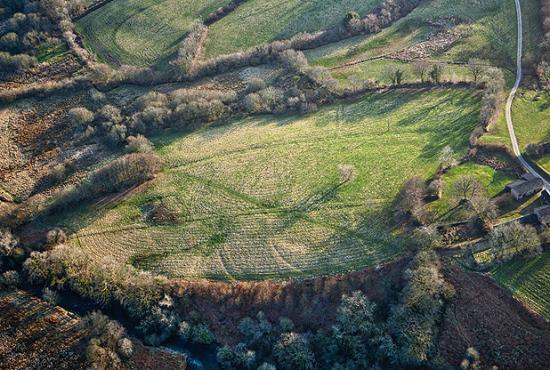
Bold shapes in the landscape, like valleys and hills, have been made by nature, but there’s a myriad of other smaller lines, bumps, humps, gouges, protrusions and prominences that have been created by humans in our ceaseless desire to survive and thrive down the ages.
Nowhere do you see evidence of such things more than in the big bare uplands where forest cover and modern development have failed to smother the evidence of our past. Go to the tops of Exmoor or Dartmoor on a sunny autumn morning or late afternoon and you will see all manner of curious shapes marked by long shadows in the turf. They may be mere humps or bumps, but each has a story, each can potentially tell a tale of blood, sweat and tears, and each it in its own modest way can further our understanding of the nation’s history.
However, the best way of seeing these marks in a landscape is to go aloft in an aeroplane – which, thankfully for archaeologists, people have been doing for over 70 years. Now the results of a survey of more than 10,000 aerial photographs of Exmoor have provided experts with over 2,000 previously unrecognised archaeological sites, plus new information on another 800 known monuments.
And the curious, sometimes mysterious, markings of this one Westcountry wilderness have now been detailed in a fascinating new book produced by English Heritage in conjunction with the Exmoor National Park Authority (ENPA).
One of the historic field gutter systems seen from the air, at Brightworthy Farm on Exmoor
The Archaeology of Hill Farming on Exmoor tells, for the first time, the story of agriculture on the moors. It is the result of two years of systematic survey work carried out by authors Cain Hegarty and Rob Wilson-North, who is the ENPA’s archaeologist. The book is rich in aerial photographs, reconstructions, detailed maps and plans which chart the story of hill-farming since the medieval period using archaeological evidence – and is divided into three sections: the Royal Forest, the commons and the farmlands of the surrounding parishes.
“Aerial photographs really do show the impact of people in shaping what is often viewed as an unspoilt landscape,” said Rob Wilson-North when he spoke to the Western Morning News about the new book.
“English Heritage have tried to cover the whole of the country looking at all the available aerial photos in the National Mapping Programme – they then map the features on photographs, and the reason we wanted to do more work on them on Exmoor was to find sites we didn’t know about.
“2,000 previously unrecognised archaeological sites is a very large number and was certainly surprising to us. People might think we found a lot of Stonehenges that we didn’t know about before, but it wasn’t like that. They were almost all smaller things that had slipped through the net. Things like water management features that have never been seen before…
“The book was one of those no-brainers – having looked at the photos we wanted to go on and look at the process of farming in the hills,” said Rob, who went on to talk about the ancient Royal Forest of Exmoor… “It’s real value was for livestock grazing – people around the Forest took their animals up there in the summer, so it was a good supplement to their income. And I mean people from around the Forest, not just local people – animals were coming up all the way from Barnstaple, so the grazing was very valuable. That comes from the fact that so much land was enclosed very early in the Westcountry.
“The Royal Forest was surrounded by commons and they were surrounded by the parishes – we have an early map showing this which is more conceptual than real – but it works very well and it’s why we structured the book in the way we did.”
The aerial photographs taken down the decades can show even the most minimal of markings – like the pinch points where cattle and sheep would have been herded up onto the moor. Centuries of wear and erosion by their hooves would have been enough to have left an indelible mark on the heathland. There were even huts located at such points where foresters would count the animals going to graze and so be able to make a charge accordingly…
“The telling houses are actually a bit hard to find,” said Rob. “Sometimes they’d only have been a small wooden building. But can you imagine spending all day up there counting sheep? Drifts were the places where the animals were collected. You can still see the remains of one at Preyway where animals driven up Exe Cleave into a natural amphitheatre.
“One of most interesting things to me was collaborative in which many farmers worked, especially with water management. Along some valley sides it is clear there were several farm holdings working together on the field gutter systems. They were used to get water to the steeper bits of ground to help fertilise it and keep the temperature of the ground up.
“Very often the water was taken out of a spring, run through the barnyard (with all its manure) and out into the fields – there was a lot of science and practice behind that. The Knights (the family who bought much of Exmoor in the early 1800s) were very keen on that – and were incredibly sophisticated at doing it. Some of the field gutter systems were used almost to the end of the 20th century near Winsford and Minehead – and some people still talk about bringing them back.
“People like the efficiency of the system – a man would go out with a shovel and help the water along the gutter – then, when he didn’t want it to go further, he’d block it with a few turves. Later he’d go back later, lift out the blockage and allow the water to flow further along the valley.
“The Knights brought shepherds down from Scotland so they could keep sheep in winter – until then no one in the Westcountry kept animals on the high moors in winter months – and they built small farms on the moors in a style you won’t see until you reach Scotland…
“But the Knights wrote so little down, it’s almost like trying to understand a prehistoric landscape,” said Rob, adding that he and his team are still discovering new things about the old estate they hadn’t known before. “One of the great ironies was that they were short of water to power the farms – they dug drains and made canals because, although it rains a lot, the water has quickly gone off down the valleys.
“So the aerial perspective is an amazing one – it can help you find things out you’d never thought existed. The first aerial photo taken especially for archaeological purposes unlocked the way we looked at things – and now we use photos taken back to the 1940s taken by the Royal Air Force. They show us so much.
“And we still commission aerial photographs with English Heritage,” said Rob, who tends to get the work done in April. “You have the length of the days and the bracken has hopefully been knocked back over the winter so there’s not so much cover.”
I put it to Rob that anyone could go out – without an aeroplane – on one of the fine clear sunny autumnal days we enjoy at this time of year and see strange shapes in the landscape – then try to work out what had gone on in the location in years gone by…
“Absolutely! I love that side of archaeology,” he replied. “Once you start digging holes in the ground you need experts to come in and do the archaeology properly – but the ability to look at shape in the ground…